INSPIRE Geoportal
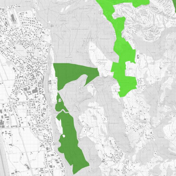
Waldreservate und Sonderwaldflächen
Waldreservate und Sonderwaldflächen Liechtensteins sind gemäss Waldgesetz (LGBl. 1991 Nr. 42) mit der Verordnung über Waldreservate und Sonderwaldflächen (LGBl. 2000 Nr. 230) geschützt. Waldreservate sind Waldflächen, die der ungestörten, dynamischen Entwicklung überlassen werden. Sonderwaldflächen sind Waldflächen mit vorrangiger Naturschutz- und Landschaftsschutzfunktionen, in denen dem Schutzziel entsprechende Massnahmen durchgeführt werden können.
Simple
-
Date (Publication)Data (Pubblicazione)Date (Publication)Datumsangaben (Publikation)
- 2006-03-17
-
IdentificateurIdentificatoreCitation identifierIdentifikator
- https://metadata.geo.llv.li/02ab142a-7ff2-4dab-abb2-5d79cf2ffcb0
-
Zweck
-
Gemäss Art. 12 des Waldgesetzes kann aus ökologischen Erwägungen auf die Bewirtschaftung des Waldes verzichtet werden. Die Regierung hat im Einvernehmen mit den Waldeigentümern Waldreservate ausgeschieden, deren Abgrenzung mit diesem Layer festgelegt wird.
-
EtatStatusStatusBearbeitungsstatus
-
FinaliséCompletatoCompletedAbgeschlossen
- Point of contact
-
Organisation name Individual name Electronic mail address Role Amt für Umwelt (LI)
Office de l'environnement
Amt für Umwelt
Amt für Umwelt
Point de contactPunto di contattoPoint of contactAnsprechpartner
- Resource format
-
Name Version INTERLIS 1 (ITF)
ESRI Shapefile (SHP)
-
GEMET
-
-
Naturschutz
préservation de la nature
conservazione della natura
nature conservation
-
Wald
bois
bosco
wood
-
-
GEMET - INSPIRE themes, version 1.0
-
-
Lebensräume und Biotope
Habitats et biotopes
Habitat e biotopi
Habitats and biotopes
-
Schutzgebiete
Sites protégés
Siti protetti
Protected sites
-
-
geocat.ch
-
-
INSPIRE
INSPIRE
INSPIRE
INSPIRE
-
-
Spatial scope
-
-
National
Nationales
Nazionali
National
-
-
GEMET
-
-
Landschaft
paysage
paesaggio
landscape
-
-
geocat.ch
-
-
Natur
nature
natura
nature
-
-
Anwendungseinschränkungen
-
geührenpflichtig
-
Contraintes d'accèsVincoli di accessoAccess constraintsZugriffseinschränkungen
-
LicenceLicenzaLicenseLizenz
-
Contraintes d'utilisationVincoli di fruibilitàUse constraintsNutzungseinschränkungen
-
LicenceLicenzaLicenseLizenz
-
Andere Einschränkungen
-
keine Eschränkung
-
Type de représentation spatialeTipo di rappresentazione spazialeSpatial representation typeRäumliche Darstellungsart
-
VecteurDati vettorialiVectorVektor
-
Distance de résolutionDistanzaDistanceDistanz
- 1 m
-
Langue de la ressourceLingua dei datiLanguageSprache
- Deutsch
-
Encodage des caractèresSet dei caratteri dei datiCharacter setZeichensatz
-
Utf8UTF8UTF8Utf8
-
Catégorie ISOTemaTopic categoryThematik
-
-
Biologie, faune et floreBiologiaBiotaBiologie
-
Infrastructures militairesInformazioni militariIntelligence militaryMilitär und Aufklärung
-
SociétéSocietàSocietyGesellschaft
-
Étendue
Estensione
Extent
Ausdehnung
-
BeschreibungDescriptionDescrizioneDescription
-
Liechtenstein
Liechtenstein
Liechtenstein
Liechtenstein
))

-
Nom du système de référenceIdentificatore del sistema di riferimentoReference system identifierIdentifikator des Referenzsystems
-
http://www.opengis.net/def/crs/EPSG/0/2056
-
Nom du système de référenceIdentificatore del sistema di riferimentoReference system identifierIdentifikator des Referenzsystems
-
http://www.opengis.net/def/crs/EPSG/0/4936
-
Niveau topologieLivello di topologiaTopology levelTopologielevel
-
Topologie de réseau complèteGrafo planare completoFull planar graphFlächen
-
Type de géométries des objetsOggetto di tipo geometricoGeometric object typeGeometrietyp
-
PolygoneSuperficieSurfaceFläche
-
Nombre d'objets géométriquesConteggio oggetto geometricoGeometric object countAnzahl
- 146
- Distribution format
-
Name Version INTERLIS 1 (ITF)
AutoCAD DXF (DXF)
ESRI Shapefile (SHP)
- Distributor contact
-
Organisation name Individual name Electronic mail address Role Amt für Tiefbau und Geoinformation
Amt für Tiefbau und Geoinformation
Amt für Tiefbau und Geoinformation
Civil Engineering and Geoinformation Office
Point de contactPunto di contattoPoint of contactAnsprechpartner
- OnLine resource
-
Protocol Linkage Name WWW:LINK
https://service.geo.llv.li/ Geodatenportal FL
WWW:LINK-1.0-http--link
https://service.geo.llv.li/wmsli/service?service=WMS&language=ger&request=GetCapabilities OGC WMS Service der Liechtensteinen Landesverwaltung
-
NiveauLivelloHierarchy levelBezugsebene
-
Jeu de donnéesDatasetDatasetDatenbestand
Résultat de conformité
Conformità
Conformance result
Konformitätsergebnis
-
Date (Publication)Data (Pubblicazione)Date (Publication)Datumsangaben (Publikation)
- 2010-12-08
- Explanation
-
Gemäss Inspire-Bestandteil des Themas Schutzgebiete
-
Degré de conformitéPassPassBestanden
- No
-
Erläuterung
-
Digitalisiert ab Landeskarte 1:10'000 resp 1:25'000
-
LangueLinguaLanguageSprache
- Deutsch
-
Inclus dans le jeu de donnéesIncluded with datasetIncluded with datasetIm Datenbestand enthalten
-
Date (Création)Data (Creazione)Date (Creation)Datumsangaben (Erstellung)
- 2012-01-16
Metadata
-
Identifiant de la ficheIdentificatore del file di metadatiFile identifierMetadatensatzidentifikator
- 02ab142a-7ff2-4dab-abb2-5d79cf2ffcb0 XML
-
LangueLingua dei metadatiMetadata languageSprache
- Deutsch
-
Jeu de caractèresSet dei caratteri dei metadatiCharacter setZeichensatz
-
Utf8UTF8UTF8Utf8
-
Type de ressourceLivello gerarchicoHierarchy levelHierarchieebene
-
Jeu de donnéesDatasetDatasetDatenbestand
-
Date des métadonnéesData dei metadatiDate stampDatum
- 2024-05-16T11:46:55.79Z
- Metadata standard name
-
GM03 2+
- Metadata author
-
Organisation name Individual name Electronic mail address Role Amt für Tiefbau und Geoinformation
Amt für Tiefbau und Geoinformation
Amt für Tiefbau und Geoinformation
Civil Engineering and Geoinformation Office
Point de contactPunto di contattoPoint of contactAnsprechpartner
- Dataset URI
- Other language
-
Language Character encoding FrançaisFranceseFrenchFranzösischUtf8UTF8UTF8Utf8ItalienItalianoItalianItalienischUtf8UTF8UTF8Utf8AnglaisIngleseEnglishEnglischUtf8UTF8UTF8Utf8AllemandTedescoGermanDeutschUtf8UTF8UTF8Utf8