 INSPIRE Geoportal
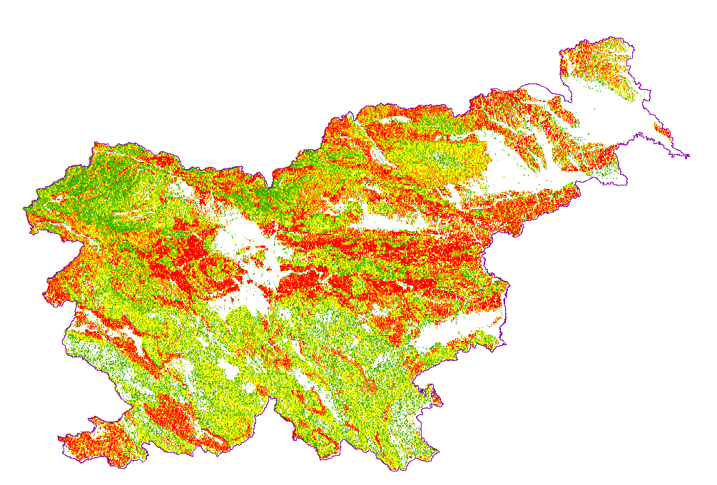
Landslide susceptibility map
Simple
-
Alternate title
-
Landslide susceptibility
-
Date (Creation)
- 2006-12-01
-
Date (Publication)
- 2006-12-01
-
Date (Revision)
- 2006-12-01
-
Citation identifier
- SI.GEOZS.INZ.ZEMPLAZ / e030855e-e8b4-4443-88e1-e2aefbe3918b
-
Purpose
-
Geohazard
- Point of contact
-
Organisation name Individual name Electronic mail address Role Geološki zavod Slovenije
dr. Matevž Novak
matevz.novak@geo-zs.si
Point of contactGeološki zavod Slovenije
info@geo-zs.si
OwnerGeološki zavod Slovenije
info@geo-zs.si
DistributorGeološki zavod Slovenije
info@geo-zs.si
Custodian
-
Maintenance and update frequency
-
As needed
-
GEMET - INSPIRE themes, version 1.0
-
-
Natural risk zones
-
-
Place
-
-
Slovenia
-
-
Theme
-
-
geology
-
landslide
-
-
Theme
-
-
INSPIRE
-
-
Discipline
-
-
Engineering geology
-
-
Spatial scope
-
-
National
-
-
Access constraints
-
Other restrictions
-
Use constraints
-
Copyright
-
Use constraints
-
Intellectual property rights
-
Other constraints
-
Data is available under a Creative Commons - Attribution 4.0 International (CC BY 4.0) license. ( https://creativecommons.org/licenses/by/4.0)
-
Use limitation
-
Data is available under a Creative Commons - Attribution 4.0 International (CC BY 4.0) license. ( https://creativecommons.org/licenses/by/4.0)
-
Spatial representation type
-
Grid
-
Denominator
- 250000
-
Distance
- 50 m
-
Language
- slv
-
Character set
-
UTF8
-
Topic category
-
-
Geoscientific information
-
-
Description
-
Slovenia
))
- Begin date
- 2003-01-01
- End date
- 2006-12-31
-
Reference system identifier
- http://www.opengis.net/def/crs/EPSG/0/3912
-
Reference system identifier
- http://www.opengis.net/def/crs/EPSG/0/4326
-
Reference system identifier
- http://www.opengis.net/def/crs/EPSG/0/4258
-
Reference system identifier
- http://www.opengis.net/def/crs/EPSG/0/3034
-
Reference system identifier
- http://www.opengis.net/def/crs/EPSG/0/3794
-
Topology level
-
Geometry only
- Distribution format
-
Name Version ESRI Shapefile
*
WMS
1.3.0
- OnLine resource
-
Protocol Linkage Name OGC:WMS
https://mapserver.geo-zs.si/cgi-bin/masprem? ver_plaz
WWW:LINK-1.0-http--link
https://geoserver.geo-zs.si/pub-ins-data/nz/wms?
-
Hierarchy level
-
Dataset
Conformance result
-
Date (Publication)
- 2010-12-08
-
Explanation
-
See the referenced specification
-
Pass
- No
-
Statement
-
percentCoverage=100;geometricHarmonization=100;thematicHarmonization=100;geometricHarmonizationDescription;thematicHarmonizationDescription;
- Description
-
Opis
matematični model verjetnosti pojavljanja plazov v Sloveniji, merilo vira: 1:250.000, datum vira: 2005, datum zajema: 2005, datum zadnjega popravka: 2005. Avtorja: Marko Komac in Mihael Ribičič.
Metadata
-
File identifier
- 04b5a38e-ea78-4e68-aa36-9528d792d54a XML
-
Metadata language
- slv
-
Character set
-
UTF8
-
Hierarchy level
-
Dataset
-
Date stamp
- 2022-01-26T13:01:44
- Metadata standard name
-
ISO 19115:2003/19139
- Metadata standard version
-
1.0
- Metadata author
-
Organisation name Individual name Electronic mail address Role Geološki zavod Slovenije
Matija Krivic
matija.krivic@geo-zs.si
Point of contact
- Other language
-
Language Character encoding EnglishUTF8
Overviews
Spatial extent
Provided by
