INSPIRE Geoportal
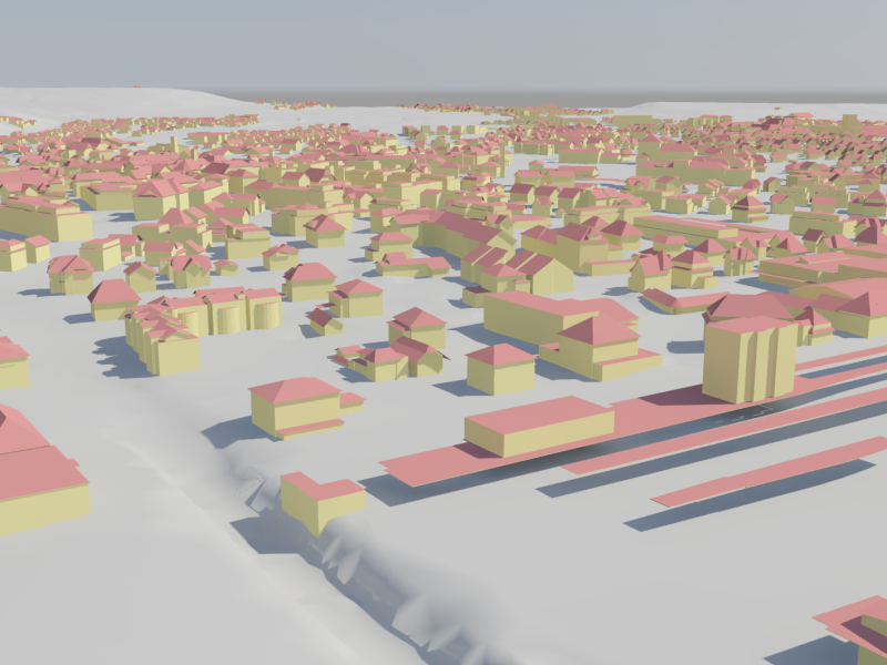
swissBUILDINGS3D 2.0
swissBUILDINGS3D 2.0 is a vector based dataset which describes buildings as 3D-models with roof geometries and roof overhangs. The high level of detail in all three dimensions, high coverage and the realistic rendering of the building volume bodies make this product a valuable basic dataset for a large range of applications.
Simple
- Alternate title
-
3D buildings
- Date (Creation)
- 2014-09-01
- Date (Revision)
- 2024-05-31
- Citation identifier
- ch.swisstopo.swissbuildings3d_2
- Collective title
-
Topografisches Landschaftsmodell (Landesvermessung)
- Point of contact
-
Organisation name Individual name Electronic mail address Role Federal Office of Topography swisstopo
Point of contact Federal Office of Topography swisstopo
Owner
- Maintenance and update frequency
- Not planned
-
geocat.ch
-
-
official geodata
-
GIS (Geographic Information System)
-
Conservation and archiving planning AAP - Confederation
-
opendata.swiss
-
landscape model
-
-
GEMET
-
-
geographic information system
-
-
GEMET - INSPIRE themes, version 1.0
-
-
Buildings
-
-
geocat.ch
-
-
FSDI Federal Spatial Data Infrastructure
-
Resource constraints
- Other constraints
- Opendata BY: Open use. Must provide the source.
- Spatial representation type
- Vector
- Language
- Deutsch
- Language
- Deutsch
- Character set
- UTF8
- Topic category
-
- Structure
Extent
- Description
-
Switzerland
))

Extent
- Description
-
Liechtenstein
))

- Supplemental Information
-
-
- Reference system identifier
- EPSG:2056
- Reference system identifier
- EPSG:21781
- Reference system identifier
- EPSG:5728
- Topology level
- Topology 3D
- Geometric object type
- Solid
- Distribution format
-
Name Version ESRI File Geodatabase FileGDB (GDB)
ESRI Shapefile (SHP)
Google Keyhole Markup Language (KML)
AutoCAD DXF (DXF)
City Geography Markup Language (CityGML)
-
Wavefront (.obj)
-
- OnLine resource
-
Protocol Linkage Name WWW:LINK
https://www.swisstopo.admin.ch/de/landschaftsmodell-swissbuildings3d-2-0 swissBUILDINGS3D 2.0
CHTOPO:specialised-geoportal
https://map.geo.admin.ch/?topic=swisstopo&lang=de&bgLayer=ch.swisstopo.pixelkarte-farbe map.geo.admin.ch
WWW:DOWNLOAD-URL
https://www.swisstopo.admin.ch/de/landschaftsmodell-swissbuildings3d-2-0
- Units of distribution
-
Gemeinden
- OnLine resource
-
Protocol Linkage Name OPENDATA:SWISS
https://opendata.swiss/de/perma/0a6773ee-7ab8-422b-b3b9-18cc292b359e@bundesamt-fur-landestopografie-swisstopo Permalink opendata.swiss
- Hierarchy level
- Dataset
- Statement
-
-
- Included with dataset
- No
- Title
-
swissBUILDINGS3D 2.0
- Date (Publication)
- 2024-05-31
Metadata
- File identifier
- 0a6773ee-7ab8-422b-b3b9-18cc292b359e XML
- Metadata language
- Deutsch
- Character set
- UTF8
- Hierarchy level
- Dataset
- Date stamp
- 2024-11-20T15:03:16.592Z
- Metadata standard name
-
GM03 2+
- Metadata author
-
Organisation name Individual name Electronic mail address Role Federal Office of Topography swisstopo
Point of contact
- Other language
-
Language Character encoding French UTF8 Italian UTF8 English UTF8 Romansh UTF8 German UTF8