 INSPIRE Geoportal
swissBUILDINGS3D 2.0
swissBUILDINGS3D 2.0
swissBUILDINGS3D 2.0
swissBUILDINGS3D 2.0
swissBUILDINGS3D
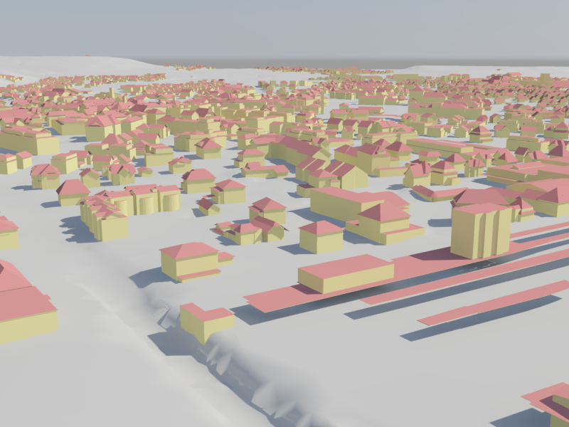
swissBUILDINGS3D 2.0 ist ein Vektordatensatz, der Gebäude als 3D-Modelle mit Dachformen und Dachüberständen darstellt. Die hohe Genauigkeit in allen drei Dimensionen, die grossflächige Abdeckung sowie die realitätsnahe Wiedergabe der Gebäudevolumenkörper machen dieses Produkt zu einem wertvollen Basisdatensatz für verschiedenste Anwendungen.
swissBUILDINGS3D 2.0 est un jeu de données vectorielles qui représente les bâtiments modélisés en 3D avec les formes des toits et avant-toits. La précision élevée dans chacune des trois dimensions, sa couverture très étendue ainsi que la reproduction particulièrement réaliste des volumes des bâtiments font de ce produit un jeu de données de base très précieux pour un large éventail d’applications.
swissBUILDINGS3D 2.0 è un set di dati vettoriali che rappresenta gli edifici sotto forma di modelli in 3D, con le forme dei tetti e dei relativi bordi. L’alto grado di precisione in tutte e tre le dimensioni, la copertura estremamente estesa e la riproduzione realistica dei volumi degli edifici fanno di questo prodotto un set di dati di base prezioso per un ampio ventaglio di applicazioni.
swissBUILDINGS3D 2.0 is a vector based dataset which describes buildings as 3D-models with roof geometries and roof overhangs. The high level of detail in all three dimensions, high coverage and the realistic rendering of the building volume bodies make this product a valuable basic dataset for a large range of applications.
swissBUILDINGS3D 1.0 è in'unitad da datas d'edifizis en 3D davart la Svizra ed il Principadi da Liechtenstein (FL) ch'è adattada per in grond dumber da modellisaziuns e da visualisaziuns. L'unitad da datas è vegnida generada a partir dals elements da basa da VECTOR25 plans d'edifizis e surfatschas da guaud. Las autezzas dals edifizis e lur autezzas sur mar èn deducidas dal model numeric da surfatscha (MNS) respectivamain dal model numeric dal terren ch'è deducì da quel da la mesiraziun uffiziala (MNT-MU). L'autezza (height) è vegnida calculada per mintga edifizi definì da ses volumen, e quai sin basa dals puncts correspundents dal scan da laser. swissBUILDINGS3D descriva ils volumens dals edifizis senza la furma da lur tetgs e correspunda ad in simpel model urban en 3D. La represchentaziun dals models urbans en 3D vegn fatga tenor differents grads da specificaziun. Il standard CityGML prevesa tschintg grads da specificaziun (levels of detail, LOD) che sa basan in sin l'auter. swissBUILDINGS3D correspunda al nivel LOD 1 ch'è in model urban simpel, per il qual las geometrias dals edifizis vegnan descrittas tras prismas extrudidas (cubus). Las furmas dals tetgs na vegnan betg resguardadas. L'unitad da datas na vegn betg actualisada.
Simple
-
AlternativtitelAutres appellations ou acronymesTitolo alternativoAlternate titleAlternate title
-
3D-Gebäude
Les bâtiments en 3D
Gli edifici in 3D
3D buildings
Edifizis en 3D
-
Date (Création)Data (Creazione)Date (Creation)Date (Creation)Datumsangaben (Erstellung)
- 2014-09-01
-
Date (Révision)Data (Revisione)Date (Revision)Date (Revision)Datumsangaben (Überarbeitung)
- 2023-11-29
-
IdentificateurIdentificatoreCitation identifierCitation identifierIdentifikator
- ch.swisstopo.swissbuildings3d_2
-
Gemeinsamer TitelTitre collectifTitolo collettivo
-
Topografisches Landschaftsmodell (Landesvermessung)
Modèle topographique du paysage (mensuration nationale)
Modello topografico del paesaggio (misurazione nazionale)
- Point of contact
-
Organisation name Individual name Electronic mail address Role Bundesamt für Landestopografie swisstopo
Office fédéral de topographie swisstopo
Ufficio federale di topografia swisstopo
Federal Office of Topography swisstopo
Uffizi federal da topografia swisstopo
Point de contactPunto di contattoPoint of contactPoint of contactAnsprechpartnerBundesamt für Landestopografie swisstopo
Office fédéral de topographie swisstopo
Ufficio federale di topografia swisstopo
Federal Office of Topography swisstopo
Uffizi federal da topografia swisstopo
PropriétaireProprietarioOwnerOwnerEigentümer / Datenherr
-
Fréquence de mise à jourFrequenza di aggiornamentoMaintenance and update frequencyMaintenance and update frequencyÜberarbeitungsintervall
-
AnnuelleAnnualeAnnuallyAnnuallyJährlich
-
geocat.ch
-
-
GIS (Geografisches Informationssystem)
SIG (Système d'Information Géographique)
SIG (Sistema Informativo Geografico)
GIS (Geographic Information System)
-
Landschaftsmodell
modèle du territoire
modello del territorio
landscape model
-
Geobasisdaten
géodonnées de base
geodati di base
official geodata
-
Aufbewahrungs- und Archivierungsplanung AAP - Bund
Planification de la conservation et de l'archivage AAP - Conféderation
Pianificazione della conservazione e dell’archiviazione AAP - Confederazione
Conservation and archiving planning AAP - Confederation
-
opendata.swiss
opendata.swiss
opendata.swiss
opendata.swiss
opendata.swiss
-
-
GEMET
-
-
Geographisches Informationssystem
système d'information géographique
sistema informativo geografico
geographic information system
-
-
GEMET - INSPIRE themes, version 1.0
-
-
Gebäude
Bâtiments
Edifici
Buildings
-
-
geocat.ch
-
-
BGDI Bundesgeodaten-Infrastruktur
IFDG l’Infrastructure Fédérale de données géographiques
IFDG Infrastruttura federale dei dati geografici
FSDI Federal Spatial Data Infrastructure
-
Contraintes sur la ressource
Vincoli sulla risorsa
Resource constraints
Resource constraints
Ressourceneinschränkungen
-
Andere EinschränkungenAutres contraintesAltri vincoliOther constraints
-
Opendata BY: Freie Nutzung. Quellenangabe ist Pflicht.Opendata BY: Utilisation libre. Obligation d’indiquer la source.Opendata BY: Libero utilizzo. Indicazione della fonte obbligatoria.Opendata BY: Open use. Must provide the source.
-
Type de représentation spatialeTipo di rappresentazione spazialeSpatial representation typeSpatial representation typeRäumliche Darstellungsart
-
VecteurDati vettorialiVectorVectorVektor
-
Langue de la ressourceLingua dei datiLanguageLanguageSprache
- Deutsch
-
Langue de la ressourceLingua dei datiLanguageLanguageSprache
- Deutsch
-
Encodage des caractèresSet dei caratteri dei datiCharacter setCharacter setZeichensatz
-
Utf8UTF8UTF8UTF8Utf8
-
Catégorie ISOTemaTopic categoryTopic categoryThematik
-
-
Constructions et ouvragesStruttureStructureStructureBauwerke
-
Étendue
Estensione
Extent
Extent
Ausdehnung
-
BeschreibungDescriptionDescrizioneDescriptionDescription
-
Schweiz
Suisse
Svizzera
Switzerland
Svizra
))

Étendue
Estensione
Extent
Extent
Ausdehnung
-
BeschreibungDescriptionDescrizioneDescriptionDescription
-
Liechtenstein
Liechtenstein
Liechtenstein
Liechtenstein
Liechtenstein
))

-
ZusatzinformationInformations supplémentairesInformazioni supplementariSupplemental InformationSupplemental Information
-
-
-
-
-
-
-
Nom du système de référenceIdentificatore del sistema di riferimentoReference system identifierReference system identifierIdentifikator des Referenzsystems
-
EPSG:2056EPSG:2056
-
Nom du système de référenceIdentificatore del sistema di riferimentoReference system identifierReference system identifierIdentifikator des Referenzsystems
-
EPSG:21781EPSG:21781
-
Nom du système de référenceIdentificatore del sistema di riferimentoReference system identifierReference system identifierIdentifikator des Referenzsystems
-
EPSG:5728EPSG:5728
-
Niveau topologieLivello di topologiaTopology levelTopology levelTopologielevel
-
Topologie 3DTopologia 3DTopology 3DTopology 3DKörper
-
Type de géométries des objetsOggetto di tipo geometricoGeometric object typeGeometric object typeGeometrietyp
-
VolumeSolidoSolidSolidKörper
- Distribution format
-
Name Version ESRI File Geodatabase
-
ESRI Shapefile
-
KML
-
DXF
-
CityGML
-
- OnLine resource
-
Protocol Linkage Name WWW:LINK
https://www.swisstopo.admin.ch/de/geodata/landscape/buildings3d2.html swissBUILDINGS3D 2.0
CHTOPO:specialised-geoportal
https://map.geo.admin.ch/?topic=swisstopo&lang=de&bgLayer=ch.swisstopo.pixelkarte-farbe map.geo.admin.ch
map.geo.admin.ch
map.geo.admin.ch
map.geo.admin.ch
WWW:DOWNLOAD-URL
https://www.swisstopo.admin.ch/de/geodata/landscape/buildings3d2.html
- Units of distribution
-
Gemeinden
- OnLine resource
-
Protocol Linkage Name OPENDATA:SWISS
https://opendata.swiss/de/perma/0a6773ee-7ab8-422b-b3b9-18cc292b359e@bundesamt-fur-landestopografie-swisstopo Permalink opendata.swiss
Permalink opendata.swiss
Permalink opendata.swiss
Permalink opendata.swiss
-
NiveauLivelloHierarchy levelHierarchy levelBezugsebene
-
Jeu de donnéesDatasetDatasetDatasetDatenbestand
-
Erläuterung
-
-
-
Inclus dans le jeu de donnéesIncluded with datasetIncluded with datasetIncluded with datasetIm Datenbestand enthalten
- No
-
Date (Publication)Data (Pubblicazione)Date (Publication)Date (Publication)Datumsangaben (Publikation)
- 2022-11-28
Metadata
-
Identifiant de la ficheIdentificatore del file di metadatiFile identifierFile identifierMetadatensatzidentifikator
- 0a6773ee-7ab8-422b-b3b9-18cc292b359e XML
-
LangueLingua dei metadatiMetadata languageMetadata languageSprache
- Deutsch
-
Jeu de caractèresSet dei caratteri dei metadatiCharacter setCharacter setZeichensatz
-
Utf8UTF8UTF8UTF8Utf8
-
Type de ressourceLivello gerarchicoHierarchy levelHierarchy levelHierarchieebene
-
Jeu de donnéesDatasetDatasetDatasetDatenbestand
-
Date des métadonnéesData dei metadatiDate stampDate stampDatum
- 2023-12-05T13:29:49.351Z
- Metadata standard name
-
GM03 2+
- Metadata author
-
Organisation name Individual name Electronic mail address Role Bundesamt für Landestopografie swisstopo
Office fédéral de topographie swisstopo
Ufficio federale di topografia swisstopo
Federal Office of Topography swisstopo
Uffizi federal da topografia swisstopo
Point de contactPunto di contattoPoint of contactPoint of contactAnsprechpartner
- Other language
-
Language Character encoding FrançaisFranceseFrenchFrenchFranzösischUtf8UTF8UTF8UTF8Utf8ItalienItalianoItalianItalianItalienischUtf8UTF8UTF8UTF8Utf8AnglaisIngleseEnglishEnglishEnglischUtf8UTF8UTF8UTF8Utf8RomancheRomancioRomanshRomanshRätoromanischUtf8UTF8UTF8UTF8Utf8AllemandTedescoGermanGermanDeutschUtf8UTF8UTF8UTF8Utf8
Overviews
Spatial extent

Provided by
