 INSPIRE Geoportal
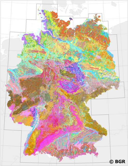
Soil Map of Germany 1:200,000
Nation-wide land use strategies and planning as well as soil protection require harmonised and standardised area-covering information. Such data is provided by the digital Soil Map of Germany at scale 1:200,000 (BUEK200). The pedological data of this map, stored in a relational database, is used to demonstrate the abundance and the associations of soils and their basic properties in Germany. However, the main purpose of the BUEK200 is to offer a database which allows the estimation and visualisation of soil functions, soil potentials and soil hazards. To achieve comparable soil information throughout Germany the BGR and the soil surveys of the federal lands have elaborated and defined BUEK200 standards concerning the map (e.g. delineation and description of mapping units) and its database (e.g. database model, parameters, codification).
Simple
- Alternate title
-
BÜK200 (Serie)
-
Date (Publication)
- 2018-03-01
-
Date (Revision)
- 2022-12-20
-
Citation identifier
- 3E80DA1A-A9A7-45A3-9CC7-79796FE9ABA4
- Other citation details
-
Größe der gedruckten Karten: meist ca. 100 x 68,5 cm - Size of printed map: mostly approx. 100 x 68.5 cm
-
Status
-
Completed
- Point of contact
-
Organisation name Individual name Electronic mail address Role Bundesanstalt für Geowissenschaften und Rohstoffe
Stegger, Ulrich
Point of contact
-
GEMET - INSPIRE themes, version 1.0
-
-
Soil
-
Boden
-
-
Theme
-
-
BÜK200
-
inspireidentifiziert
-
opendata
-
-
Place
-
-
Deutschland
-
-
Spatial scope
-
-
National
-
-
Access constraints
-
Other restrictions
- Other constraints
- Es gelten keine Zugriffsbeschränkungen
-
Use constraints
-
Other restrictions
- Other constraints
-
Allgemeine Geschäftsbedingungen, siehe https://www.bgr.bund.de/AGB - General terms and conditions, see https://www.bgr.bund.de/AGB_en. Die bereitgestellten Informationen sind bei Weiterverwendung wie folgt zu zitieren: Datenquelle: BÜK200, (C) BGR, Hannover, 2018.
- Other constraints
-
Dieser Datensatz kann gemäß der "Nutzungsbestimmungen für die Bereitstellung von Geodaten des Bundes" ( https://sg.geodatenzentrum.de/web_public/gdz/lizenz/geonutzv.pdf) genutzt werden.
- Other constraints
-
{"id": "geoNutz/20130319", "name": "Nutzungsbestimmungen für die Bereitstellung von Geodaten des Bundes", "url": " https://sg.geodatenzentrum.de/web_public/gdz/lizenz/geonutzv.pdf", "quelle": "BÜK200, (C) BGR, Hannover, 2018"}
-
Spatial representation type
-
Text, table
-
Denominator
- 200000
-
Language
- Deutsch
-
Character set
-
UTF8
-
Topic category
-
-
Geoscientific information
-
))
-
Geographic identifier
- Regionalschlüssel / 000000000000
- Unique resource identifier
- EPSG:4326
- Distribution format
-
Name Version MS Access
n/a
-
Transfer size
- 3
- OnLine resource
-
Protocol Linkage Name https://download.bgr.de/bgr/boden/BUEK200/Datenbank/BUEK200DE_Sachdaten_V0.8.zip BÜK200 (Serie) (MS Access)
- OnLine resource
-
Protocol Linkage Name https://www.bgr.bund.de/buek200
- OnLine resource
-
Protocol Linkage Name https://download.bgr.de/bgr/Boden/BUEK200/Flyer/Flyer_BUEK200.pdf
- OnLine resource
-
Protocol Linkage Name https://download.bgr.de/bgr/Boden/BUEK200/Indexkarte/Indexkarte_BUEK200.pdf
- OnLine resource
-
Protocol Linkage Name https://services.bgr.de/boden/buek200
-
Hierarchy level
-
Series
Conformance result
-
Date (Publication)
- 2010-12-08
- Explanation
-
siehe dazu die angegebene Durchführungsbestimmung
- Statement
-
Bodendaten und -karten 1:25.000 bis 1:100.000 von 1991-2015 (Staatliche Geologische Dienste der Länder).
Metadata
-
File identifier
- 154997F4-3C14-4A53-B217-8A7C7509E05F XML
-
Metadata language
- Deutsch
-
Character set
-
UTF8
-
Hierarchy level
-
Series
- Hierarchy level name
-
Boden
-
Date stamp
- 2023-08-22
- Metadata standard name
-
INSPIRE Metadata Implementing Rules: Technical Guidelines based on EN ISO 19115 and EN ISO 19119
- Metadata standard version
-
n/a
- Metadata author
-
Organisation name Individual name Electronic mail address Role Bundesanstalt für Geowissenschaften und Rohstoffe (BGR)
Point of contact
- Other language
-
Language Character encoding EnglishUTF8
Overviews
Spatial extent
Provided by
