INSPIRE Geoportal
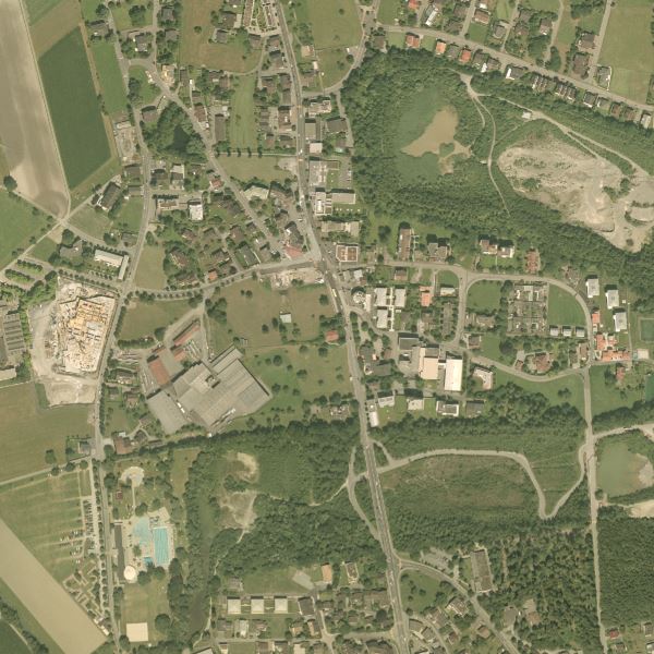
Orthophoto Liechtenstein 2006
Orthophoto Liechtenstein 2006
Orthophoto mit einer Auflösung von 12.5 cm Bodenpixel. Das Orthophoto wurde im September 2006 durch das Bundesland Vorarlberg geflogen und Liechtenstein zur Verfügung gestellt.
Orthophoto with a resolution of 12.5 cm ground pixels. The orthophoto was flown in September 2006 by the province of Vorarlberg and made available to Liechtenstein.
Simple
-
Date (Création)Data (Creazione)Date (Creation)Datumsangaben (Erstellung)
- 2006-09-01
-
IdentificateurIdentificatoreCitation identifierIdentifikator
- https://metadata.geo.llv.li/22984f78-3e29-4772-bed4-558173c0530c
-
ZweckPurpose
-
Referenzdaten für die GDI Liechtenstein
Reference data for the GDI Liechtenstein
-
EtatStatusStatusBearbeitungsstatus
-
FinaliséCompletatoCompletedAbgeschlossen
- Point of contact
-
Organisation name Individual name Electronic mail address Role Amt für Tiefbau und Geoinformation
Amt für Tiefbau und Geoinformation
Amt für Tiefbau und Geoinformation
Civil Engineering and Geoinformation Office
Point de contactPunto di contattoPoint of contactAnsprechpartner
-
Fréquence de mise à jourFrequenza di aggiornamentoMaintenance and update frequencyÜberarbeitungsintervall
-
Non planifiéeNon pianificatoNot plannedNicht geplant
- Resource format
-
Name Version GeoTIFF (GEOTIFF)
-
geocat.ch
-
-
Orthofoto
orthophoto
ortofoto
orthophoto
-
INSPIRE
INSPIRE
INSPIRE
INSPIRE
-
OpenData
OpenData
OpenData
OpenData
-
-
GEMET
-
-
Luftbild
photographie aérienne
fotografia aerea (immagine)
aerial photograph
-
-
GEMET - INSPIRE themes, version 1.0
-
-
Orthofotografie
Ortho-imagerie
Orto immagini
Orthoimagery
-
-
Spatial scope
-
-
National
Nationales
Nazionali
National
-
Contraintes sur la ressource
Vincoli sulla risorsa
Resource constraints
Ressourceneinschränkungen
Contraintes sur la ressource
Vincoli sulla risorsa
Resource constraints
Ressourceneinschränkungen
-
Anwendungseinschränkungen
-
No Conditions apply
-
Contraintes d'accèsVincoli di accessoAccess constraintsZugriffseinschränkungen
-
Autres restrictionsAltri vincoliOther restrictionsBenutzerdefinierte Einschränkungen
-
Contraintes d'utilisationVincoli di fruibilitàUse constraintsNutzungseinschränkungen
-
Autres restrictionsAltri vincoliOther restrictionsBenutzerdefinierte Einschränkungen
-
Andere EinschränkungenAutres contraintesAltri vincoliOther constraints
-
No limitations to public accessNo limitations to public accessNo limitations to public accessNo limitations to public access
-
Anwendungseinschränkungen
-
No Conditions apply
-
Contraintes d'accèsVincoli di accessoAccess constraintsZugriffseinschränkungen
-
Autres restrictionsAltri vincoliOther restrictionsBenutzerdefinierte Einschränkungen
-
Contraintes d'utilisationVincoli di fruibilitàUse constraintsNutzungseinschränkungen
-
Autres restrictionsAltri vincoliOther restrictionsBenutzerdefinierte Einschränkungen
-
Andere EinschränkungenAutres contraintesAltri vincoliOther constraints
-
No conditions to access and useNo conditions to access and useNo conditions to access and useNo conditions to access and use
-
Andere EinschränkungenAutres contraintesAltri vincoliOther constraints
-
Opendata BY: Freie Nutzung. Quellenangabe ist Pflicht.Opendata BY: Utilisation libre. Obligation d’indiquer la source.Opendata BY: Libero utilizzo. Indicazione della fonte obbligatoria.Opendata BY: Open use. Must provide the source.
-
Type de représentation spatialeTipo di rappresentazione spazialeSpatial representation typeRäumliche Darstellungsart
-
RasterDati rasterGridRaster, Gitter
-
Distance de résolutionDistanzaDistanceDistanz
- 0.25 m
-
Langue de la ressourceLingua dei datiLanguageSprache
- Deutsch
-
Encodage des caractèresSet dei caratteri dei datiCharacter setZeichensatz
-
Utf8UTF8UTF8Utf8
-
Catégorie ISOTemaTopic categoryISO-Thematik
-
-
Carte de référence de la couverture terrestreMappe di baseImagery base maps earth coverOberflächenbeschreibung
-
Étendue
Estensione
Extent
Ausdehnung
-
BeschreibungDescriptionDescrizioneDescription
-
Liechtenstein
Liechtenstein
Liechtenstein
Liechtenstein
))

-
Nom du système de référenceIdentificatore del sistema di riferimentoReference system identifierIdentifikator des Referenzsystems
-
http://www.opengis.net/def/crs/EPSG/0/21782
-
Nom du système de référenceIdentificatore del sistema di riferimentoReference system identifierIdentifikator des Referenzsystems
-
http://www.opengis.net/def/crs/EPSG/0/4936
-
DimensionsNumero delle dimensioniNumber of dimensionsAnzahl der Dimensionen
- 2
-
Type de rasterGeometria della cellaCell geometryZellengeometrie
-
SurfaceAreaAreaFläche
-
Disponibilité des paramètres de transformationDisponibilità dei coefficienti della trasformazioneTransformation parameter availabilityVerfügbarkeit von Transformationsparametern
- Distribution format
-
Name Version GeoTIFF (GEOTIFF)
- Distributor contact
-
Organisation name Individual name Electronic mail address Role Abt. Vermessung und Geoinformation (ATG)
Abt. Vermessung und Geoinformation (ATG)
Abt. Vermessung und Geoinformation (ATG)
Surveying and Geoinformation Division
Point de contactPunto di contattoPoint of contactAnsprechpartner
- Units of distribution
-
Kacheln
- OnLine resource
-
Protocol Linkage Name WWW:LINK
https://geodaten.llv.li Geodatenportal
Geodata Portal
OGC:WMS
https://service.geo.llv.li/wmsli/service?service=WMS&language=ger&request=GetCapabilities li.abi.orthophoto2006
WWW:DOWNLOAD:GeoTIFF (GEOTIFF)
https://service.geo.llv.li/OGD/getUrl.php?dataset=orthophoto2006 Download als GeoTiff über das Geodatenportal
Download as GeoTiff via the geodata portal
-
NiveauLivelloHierarchy levelBezugsebene
-
Jeu de donnéesDatasetDatasetDatenbestand
Résultat de conformité
Conformità
Conformance result
Konformitätsergebnis
-
Titel
-
VERORDNUNG (EG) Nr. 1089/2010 DER KOMMISSION vom 23. November 2010 zur Durchführung der Richtlinie 2007/2/EG des Europäischen Parlaments und des Rates hinsichtlich der Interoperabilität von Geodatensätzen und -diensten
-
Date (Publication)Data (Pubblicazione)Date (Publication)Datumsangaben (Publikation)
- 2010-12-08
- Explanation
-
Gemäss INSPIRE Bestandteil des Themas Orthofotografie
-
Degré de conformitéPassPassBestanden
- No
-
Erläuterung
-
Bildflug
Information sur le contenu
Informazioni sul contenuto
Content Information
Dateninhalt
Metadata
-
Identifiant de la ficheIdentificatore del file di metadatiFile identifierMetadatensatzidentifikator
- 22984f78-3e29-4772-bed4-558173c0530c XML
-
LangueLingua dei metadatiMetadata languageSprache
- Deutsch
-
Jeu de caractèresSet dei caratteri dei metadatiCharacter setZeichensatz
-
Utf8UTF8UTF8Utf8
-
Type de ressourceLivello gerarchicoHierarchy levelHierarchieebene
-
Jeu de donnéesDatasetDatasetDatenbestand
-
Date des métadonnéesData dei metadatiDate stampDatum
- 2024-10-30T14:17:46.813Z
- Metadata standard name
-
GM03 2+
- Metadata author
-
Organisation name Individual name Electronic mail address Role Abt. Vermessung und Geoinformation (ATG)
Abt. Vermessung und Geoinformation (ATG)
Abt. Vermessung und Geoinformation (ATG)
Surveying and Geoinformation Division
Point de contactPunto di contattoPoint of contactAnsprechpartner
- Dataset URI
- Other language
-
Language Character encoding FrançaisFranceseFrenchFranzösischUtf8UTF8UTF8Utf8ItalienItalianoItalianItalienischUtf8UTF8UTF8Utf8AnglaisIngleseEnglishEnglischUtf8UTF8UTF8Utf8AllemandTedescoGermanDeutschUtf8UTF8UTF8Utf8