 INSPIRE Geoportal
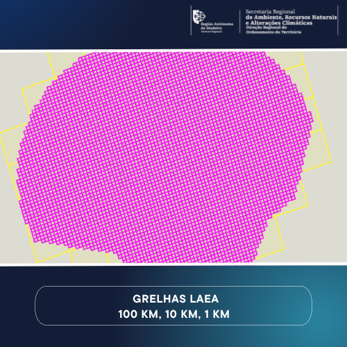
Grelha Europeia (PTRA08/LAEA-Europe) da Região Autónoma da Madeira
Grelha Europeia (PTRA08/LAEA-Europe) abrangindo o Arquipélago da Madeira, incluindo a Zona Económica Exclusiva (ZEE), com malhas de 1Km, 10 Km e 100 Km.
Simple
- Date (Creation)
- 2019-02-21
- Citation identifier
- http://id.igeo.pt/cdg/24910039-c2ff-4c02-b487-e67e99aafa39
- Purpose
-
Implementação na região do sistema de quadricula geográfica INSPIRE.
- Point of contact
-
Organisation name Individual name Electronic mail address Role Direção Regional do Ordenamento do Território
drote@madeira.gov drote@madeira.gov.pt
Point of contact
- Maintenance and update frequency
- As needed
-
Options
-
-
INSPIRECORE
-
Outra Cartografia
-
- Keywords
-
-
Quadrícula geográfica
-
PTRA08/LAEA-Europe
-
Grelha europeia
-
Geographical grid systems
-
DROTe
-
RAM
-
-
Spatial scope
-
-
Regional
-
-
ISO 19119 service taxonomy
-
-
infoMapAccessService
-
InfoCoverageAccessService
-
- Access constraints
- Other restrictions
- Other constraints
- Acesso público sem restrições
- Use constraints
- Other restrictions
- Other constraints
-
Sem restrições
- Spatial representation type
- Grid
- Denominator
- 1
- Language
- Portuguese
- Character set
- UTF8
- Topic category
-
- Location
))
- Extent type code
- Yes
- Geographic identifier
- PT3
- Reference system identifier
- EPSG / http://www.opengis.net/def/crs/EPSG/0/5633
- Distribution format
-
Name Version WMS
1.3.0
ATOM
Não se aplica
- Distributor contact
-
Organisation name Individual name Electronic mail address Role Direção Regional do Ordenamento do Território
drote@madeira.gov drote@madeira.gov.pt
Distributor
- Hierarchy level
- Dataset
Conformance result
- Date (Publication)
- 2010-12-08
- Explanation
-
Ver a especificação citada.
- Pass
- Yes
- Statement
-
Tranformação da Pan-European Equal Area Grid (Grid_ETRS89-LAEA), EPSG:3035, em novo sistema de referência de coordenadas - EPSG: 5633 (projection space: Lambert Azimuthal Equal-Area, geodetic datum: EPSG5013:PTRA08, reference ellipsoid:GRS80).
Metadata
- File identifier
- 24910039-c2ff-4c02-b487-e67e99aafa39 XML
- Metadata language
- Portuguese
- Character set
- UTF8
- Hierarchy level
- Dataset
- Hierarchy level name
-
Conjunto de dados geográficos
- Date stamp
- 2024-06-17T17:08:20
- Metadata standard name
-
ISO 19115 Sistema de Metadados dos Açores
- Metadata author
-
Organisation name Individual name Electronic mail address Role Direção Regional do Ordenamento do Território
drote@madeira.gov drote@madeira.gov.pt
Point of contact
Overviews
Spatial extent
Provided by
