 INSPIRE Geoportal
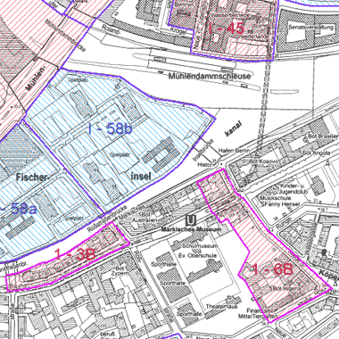
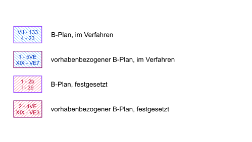
Bebauungspläne, vorhabenbezogene Bebauungspläne (Geltungsbereiche)
Geltungsbereiche der verbindlichen Bauleitplanung.
Gesamtbestand festgesetzter und im Verfahren befindlicher Bebauungspläne, einschließlich vorhabenbezogener Bebauungspläne
sowie der generellen Bebauungspläne
Simple
Identification info
- Date (Publication)
- 2004-05-03
- Citation identifier
- https://registry.gdi-de.org/id/de.be.csw/9065dcb5-5e83-358b-a340-d8f0b3f32d1b
- Presentation form
- Digital map
- Point of contact
-
Organisation name Individual name Electronic mail address Role Senatsverwaltung für Stadtentwicklung, Bauen und Wohnen Berlin
Fr. Kaiser
anna.kaiser@senstadt.ber anna.kaiser@senstadt.berlin.de
Point of contact Senatsverwaltung für Stadtentwicklung, Bauen und Wohnen Berlin
Fr. Krägel
katharina.kraegel@senstadt.ber katharina.kraegel@senstadt.berlin.de
Point of contact
- Maintenance and update frequency
- Fortnightly
- Theme
-
-
inspireidentifiziert
-
open data
-
opendata
-
Karten
-
Geodaten
-
Berlin
-
Geltungsbereiche
-
Bebauungsplan
-
Bplan
-
Bpläne
-
B-Plan
-
B-Pläne
-
- Keywords
-
-
infoMapAccessService
-
- Access constraints
- Other restrictions
- Other constraints
- Es gelten keine Zugriffsbeschränkungen
- Use constraints
- Other restrictions
- Other constraints
-
Für die Nutzung der Daten ist die Datenlizenz Deutschland - Namensnennung - Version 2.0 anzuwenden. Die Lizenz ist über https://www.govdata.de/dl-de/by-2-0 abrufbar. Der Quellenvermerk gemäß (2) der Lizenz lautet "Geoportal Berlin / [Titel des Datensatzes]".
- Other constraints
-
{ "id": "dl-by-de/2.0" , "name": " Datenlizenz Deutschland - Namensnennung - Version 2.0 ", "url": " https://www.govdata.de/dl-de/by-2-0", "quelle": "Geoportal Berlin / [Titel des Datensatzes]" }
- Service Type
- view
- Service Version
-
OGC:WMS 1.0.0
- Service Version
-
OGC:WMS 1.1.0
- Service Version
-
OGC:WMS 1.1.1
- Service Version
-
OGC:WMS 1.3.0
))
- Extent type code
- Yes
- Geographic identifier
- 110000000000
- Coupling Type
- Tight
- Contains Operations
-
Operation Name Distributed Computing Platforms Connect Point GetCapabilities
Web services https://fbinter.stadt-berlin.de/fb/wms/senstadt/bplan
- Reference system identifier
- http://www.opengis.net/def/crs/EPSG/0/25833
- Distribution format
-
Name Version Text/HTML
4.01
- Hierarchy level
- Service
- Other
-
Dienst
Conformance result
- Date (Publication)
- 2009-10-20
- Explanation
-
see referenced specification
- Pass
- Yes
Metadata
- File identifier
- 277904f0-85e6-3524-b1f2-dbea3b16c292 XML
- Metadata language
- Deutsch
- Character set
- UTF8
- Hierarchy level
- Service
- Hierarchy level name
-
Bebauungspläne, vorhabenbezogene Bebauungspläne (Geltungsbereiche) Dienst
- Date stamp
- 2023-08-16T11:15:18
- Metadata standard name
-
ISO 19115/19119 – BE
- Metadata standard version
-
1.0.0
- Metadata author
-
Organisation name Individual name Electronic mail address Role Senatsverwaltung für Stadtentwicklung, Bauen und Wohnen Berlin
fisbroker@senstadt.ber fisbroker@senstadt.berlin.de
Point of contact
Overviews
Spatial extent
Provided by
