INSPIRE Geoportal
Landeskarte 1:25'000
Carte nationale 1:25'000
Carta nazionale 1:25'000
National Map 1:25'000
Charta naziunala 1:25'000
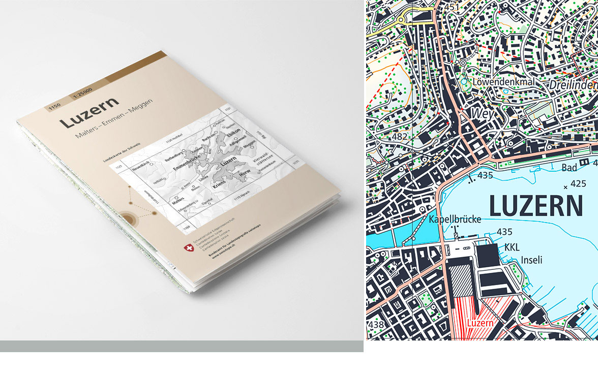
Die Landeskarte 1:25'000 ist eine topografische Karte der Schweiz mit sehr detaillierter Verkehrs-, Siedlungs-, Gelände- und Vegetationsdarstellung. Der Kartenperimeter ist in 247 Einzelblätter aufgeteilt. Die Landeskarte 1:25'000 ist in analoger (Papierkarte) und in digitaler Form (Swiss Map Raster, Swiss Map Vector) verfügbar. Die Nachführung erfolgt sektorenweise. Die verschiedenen Nachführungsstände zeigt der Layer "<a href=" https://map.geo.admin.ch/?lang=de&topic=ech&bgLayer=ch.swisstopo.pixelkarte-farbe&layers=ch.swisstopo.pixelkarte-pk25.metadata" target="_blank">Einteilung Landeskarte 25 Raster</a>".
La carte nationale au 1:25’000 est la carte topographique suisse avec une représentation très détaillée des voies de communications, des surfaces bâties, de l’hydrographie, du terrain et de la végétation. Le périmètre total est divisé en 247 feuilles. La carte nationale au 1:25’000 est disponible sous forme analogique (carte papier) et numérique (Swiss Map Raster). La mise à jour s’effectue par secteur. Les différents états de mise à jour sont indiqués dans la couche "<a href=" https://map.geo.admin.ch/?lang=fr&topic=ech&bgLayer=ch.swisstopo.pixelkarte-farbe&layers=ch.swisstopo.pixelkarte-pk25.metadata" target="_blank">Découpage carte nationale 25 Raster</a>"
La Carta nazionale 1:25'000 è una carta topografica della Svizzera con una rappresentazione estremamente dettagliata delle vie di comunicazione, degli insediamenti, dei corsi d'acqua, della vegetazione e del terreno. Il perimetro della carta è suddiviso in 247 fogli singoli. La Carta nazionale 1:25'000 è disponibile in formato analogico (cartaceo) e digitale (Swiss Map Raster, Swiss Map Vector). La carta è aggiornata per settori. I diversi stati di aggiornamento sono mostrati nel layer "<a href=" https://map.geo.admin.ch/?lang=it&topic=ech&bgLayer=ch.swisstopo.pixelkarte-farbe&layers=ch.swisstopo.pixelkarte-pk25.metadata" target="_blank">Divisione carta nazionale 25 Raster</a>"
The National Map 1:25,000 is a topographic map of Switzerland representing the areas of traffic and settlements, the topography and the vegetation in great detail. The map perimeter is divided into 247 individual sheets. The National Map 1:25,000 is published in analogue format as a printed map and in digital format as the Swiss Map Raster. The update is done by sector. The different statuses of updates are shown in the layer "<a href=" https://map.geo.admin.ch/?lang=en&topic=ech&bgLayer=ch.swisstopo.pixelkarte-farbe&layers=ch.swisstopo.pixelkarte-pk25.metadata" target="_blank">Division national map 25 Raster</a>"
La Charta naziunala 1:25'000 è ina charta topografica da la Svizra cun ina preschentaziun fitg detagliada dal traffic, dals abitadis, dal territori e da la vegetaziun. Il perimeter da la charta è dividì en 247 fegls singuls. La Charta naziunala 1:25'000 è disponibla en furma analoga (charta da palpiri) e digitala (Swiss Map Raster, Swiss Map Vector). L'actualisaziun vegn fatga tenor secturs. Die verschiedenen Nachführungsstände zeigt der Layer "<a href=" https://map.geo.admin.ch/?lang=rm&topic=ech&bgLayer=ch.swisstopo.pixelkarte-farbe&layers=ch.swisstopo.pixelkarte-pk25.metadata" target="_blank">Div. Charta naziunala 25 Raster</a>"
Simple
-
AlternativtitelAutres appellations ou acronymesTitolo alternativoAlternate titleAlternate title
-
Landeskarte 1:25'000 | LK25
Carte nationale 1:25'000 | CN25
Carta nazionale 1:25'000 | CN25
National Map 1:25'000
Charta naziunala 1:25'000 | CN25
-
Date (Création)Data (Creazione)Date (Creation)Date (Creation)Datumsangaben (Erstellung)
- 1952-06-30
-
IdentificateurIdentificatoreCitation identifierCitation identifierIdentifikator
- ch.swisstopo.pixelkarte-farbe-pk25.noscale
Identificateur
Identificatore
Citation identifier
Citation identifier
Identifikator
-
Forme de la présentationFormato di presentazionePresentation formPresentation formPräsentationsform
-
Carte papierMappa cartaceaHardcopy mapHardcopy mapAnaloge Karte
-
Forme de la présentationFormato di presentazionePresentation formPresentation formPräsentationsform
-
Carte numériqueMappa digitaleDigital mapDigital mapDigitale Karte
-
Gemeinsamer TitelTitre collectifTitolo collettivo
-
Landeskartenwerk 1:25'000 bis 1:1 Mio.
Cartes nationales du 1:25'000 au 1:1'000'000
Carte nazionali 1:25'000 - 1:1 mio.
-
ZweckButFinalità
-
Georeferenzdaten des Bundesrechts
Géodonnées de référence relevant du droit fédéral
Geodati di riferimento del diritto federale
-
EtatStatusStatusStatusBearbeitungsstatus
-
Mise à jour continueIn corsoOn goingOn goingKontinuierliche Aktualisierung
- Point of contact
-
Organisation name Individual name Electronic mail address Role Bundesamt für Landestopografie swisstopo
Office fédéral de topographie swisstopo
Ufficio federale di topografia swisstopo
Federal Office of Topography swisstopo
Uffizi federal da topografia swisstopo
PropriétaireProprietarioOwnerOwnerEigentümer / Datenherr
-
Fréquence de mise à jourFrequenza di aggiornamentoMaintenance and update frequencyMaintenance and update frequencyÜberarbeitungsintervall
-
userDefineduserDefineduserDefineduserDefineduserDefined
-
Autre fréquence de mise à jourFrequenza di manutenzione definita dall'utenteUser defined maintenance frequencyUser defined maintenance frequencyBenutzerdefiniertes Pflegeintervall
-
P6Y0M0DT0H0M0S
-
geocat.ch
-
-
Verkehrsnetz
réseau de transport
rete di trasporto
traffic network
-
opendata.swiss
opendata.swiss
opendata.swiss
opendata.swiss
opendata.swiss
-
Landeskarte
carte nationale
carta nazionale
national map
-
Aufbewahrungs- und Archivierungsplanung AAP - Bund
Planification de la conservation et de l'archivage AAP - Conféderation
Pianificazione della conservazione e dell’archiviazione AAP - Confederazione
Conservation and archiving planning AAP - Confederation
-
Geländedarstellung
représentation du terrain
rappresentazione del terreno
terrain representation
-
Geobasisdaten
géodonnées de base
geodati di base
official geodata
-
-
GEMET
-
-
Grenze
bordure
frontiera
border
-
Gewässer
eaux (géographie)
acque (geografia)
water (geographic)
-
Kartographie
cartographie
cartografia
cartography
-
Vegetation
végétation
vegetazione
vegetation
-
Relief
relief
rilievo
relief (land)
-
-
GEMET - INSPIRE themes, version 1.0
-
-
Geografische Bezeichnungen
Dénominations géographiques
Nomi geografici
Geographical names
-
-
geocat.ch
-
-
BGDI Bundesgeodaten-Infrastruktur
IFDG l’Infrastructure Fédérale de données géographiques
IFDG Infrastruttura federale dei dati geografici
FSDI Federal Spatial Data Infrastructure
-
-
geocat.ch
-
-
Topografie
topographie
topografia
topography
-
-
GEMET
-
-
Karte
cartogramme
mappa
map chart
-
Contraintes sur la ressource
Vincoli sulla risorsa
Resource constraints
Resource constraints
Ressourceneinschränkungen
-
Andere EinschränkungenAutres contraintesAltri vincoliOther constraints
-
Opendata BY: Freie Nutzung. Quellenangabe ist Pflicht.Opendata BY: Utilisation libre. Obligation d’indiquer la source.Opendata BY: Libero utilizzo. Indicazione della fonte obbligatoria.Opendata BY: Open use. Must provide the source.
-
Type de représentation spatialeTipo di rappresentazione spazialeSpatial representation typeSpatial representation typeRäumliche Darstellungsart
-
paperMappaperMappaperMappaperMappaperMap
-
Type de représentation spatialeTipo di rappresentazione spazialeSpatial representation typeSpatial representation typeRäumliche Darstellungsart
-
RasterDati rasterGridGridRaster, Gitter
-
Type de représentation spatialeTipo di rappresentazione spazialeSpatial representation typeSpatial representation typeRäumliche Darstellungsart
-
VecteurDati vettorialiVectorVectorVektor
-
Dénominateur de l'échelleDenominatoreDenominatorDenominatorMassstabszahl
- 25000
-
Langue de la ressourceLingua dei datiLanguageLanguageSprache
- Deutsch
-
Langue de la ressourceLingua dei datiLanguageLanguageSprache
- Français
-
Langue de la ressourceLingua dei datiLanguageLanguageSprache
- Italiano
-
Langue de la ressourceLingua dei datiLanguageLanguageSprache
- roh
-
Encodage des caractèresSet dei caratteri dei datiCharacter setCharacter setZeichensatz
-
Utf8UTF8UTF8UTF8Utf8
-
Catégorie ISOTemaTopic categoryTopic categoryThematik
-
-
Carte de référence de la couverture terrestreMappe di baseImagery base maps earth coverImagery base maps earth coverOberflächenbeschreibung
-
Étendue
Estensione
Extent
Extent
Ausdehnung
-
BeschreibungDescriptionDescrizioneDescription
-
Landeskarte 1:25'000
Carte nationale 1:25'000
Carta nazionale 1:25'000
National Map 1:25'000
))

-
Identifiant géographiqueidentificatore GeograficoGeographic identifierGeographic identifierGeografischer Identifikator
-
LK25CN25CN25NM25CN25
-
Nom du système de référenceIdentificatore del sistema di riferimentoReference system identifierReference system identifierIdentifikator des Referenzsystems
-
CH1903+CH1903+CH1903+CH1903+CH1903+
Distributeur
Distributore
Distributor
Distributor
Vertriebsstelle
- Distributor contact
-
Organisation name Individual name Electronic mail address Role Bundesamt für Landestopografie swisstopo
Office fédéral de topographie swisstopo
Ufficio federale di topografia swisstopo
Federal Office of Topography swisstopo
Uffizi federal da topografia swisstopo
Point de contactPunto di contattoPoint of contactPoint of contactAnsprechpartner
- Distributor format
-
Name Version TIFF
-
- Distributor contact
-
Organisation name Individual name Electronic mail address Role Bundesamt für Landestopografie swisstopo
Office fédéral de topographie swisstopo
Ufficio federale di topografia swisstopo
Federal Office of Topography swisstopo
Uffizi federal da topografia swisstopo
Point de contactPunto di contattoPoint of contactPoint of contactAnsprechpartner
- OnLine resource
-
Protocol Linkage Name MAP:Preview
https://map.geo.admin.ch/?layers=ch.swisstopo.pixelkarte-farbe-pk25.noscale Vorschau map.geo.admin.ch
Aperçu map.geo.admin.ch
Previsione map.geo.admin.ch
Preview map.geo.admin.ch
OGC:WMS
https://wms.geo.admin.ch/?SERVICE=WMS&VERSION=1.3.0&REQUEST=GetCapabilities&lang=de ch.swisstopo.pixelkarte-farbe-pk25.noscale
ch.swisstopo.pixelkarte-farbe-pk25.noscale
ch.swisstopo.pixelkarte-farbe-pk25.noscale
ch.swisstopo.pixelkarte-farbe-pk25.noscale
ch.swisstopo.pixelkarte-farbe-pk25.noscale
OGC:WMTS
https://wmts.geo.admin.ch/EPSG/3857/1.0.0/WMTSCapabilities.xml?lang=de ch.swisstopo.pixelkarte-farbe-pk25.noscale
ch.swisstopo.pixelkarte-farbe-pk25.noscale
ch.swisstopo.pixelkarte-farbe-pk25.noscale
ch.swisstopo.pixelkarte-farbe-pk25.noscale
ch.swisstopo.pixelkarte-farbe-pk25.noscale
- OnLine resource
-
Protocol Linkage Name WWW:LINK
https://shop.swisstopo.admin.ch/de/products/maps/national/lk25 WWW:DOWNLOAD-URL
https://www.swisstopo.admin.ch/de/geodata/maps/smr/smr25.html
- OnLine resource
-
Protocol Linkage Name CHTOPO:specialised-geoportal
http://map.geo.admin.ch/?selectedNode=node_ch.swisstopo.pixelkarte-farbe-pk25.noscale1&Y=660000&X=190000&zoom=1&bgLayer=ch.swisstopo.pixelkarte-farbe&layers=ch.swisstopo.pixelkarte-farbe-pk25.noscale&layers_opacity=1&layers_visibility=true&time_current=latest&lang=de OPENDATA:SWISS
https://opendata.swiss/de/perma/2987a492-a097-46f3-b162-abc1b3115f85@bundesamt-fur-landestopografie-swisstopo Permalink opendata.swiss
Permalink opendata.swiss
Permalink opendata.swiss
Permalink opendata.swiss
-
NiveauLivelloHierarchy levelHierarchy levelBezugsebene
-
Jeu de donnéesDatasetDatasetDatasetDatenbestand
-
ErläuterungGénéralités sur la provenanceStatement
-
Basiert auf der Landesvermessung
Se base sur la Mensuration
Based on the topographic survey
Metadata
-
Identifiant de la ficheIdentificatore del file di metadatiFile identifierFile identifierMetadatensatzidentifikator
- 2987a492-a097-46f3-b162-abc1b3115f85 XML
-
LangueLingua dei metadatiMetadata languageMetadata languageSprache
- Deutsch
-
Jeu de caractèresSet dei caratteri dei metadatiCharacter setCharacter setZeichensatz
-
Utf8UTF8UTF8UTF8Utf8
-
Type de ressourceLivello gerarchicoHierarchy levelHierarchy levelHierarchieebene
-
Jeu de donnéesDatasetDatasetDatasetDatenbestand
-
Date des métadonnéesData dei metadatiDate stampDate stampDatum
- 2023-12-05T09:18:24.123Z
- Metadata standard name
-
GM03 2+
- Metadata author
-
Organisation name Individual name Electronic mail address Role Bundesamt für Landestopografie swisstopo
Office fédéral de topographie swisstopo
Ufficio federale di topografia swisstopo
Federal Office of Topography swisstopo
Uffizi federal da topografia swisstopo
Point de contactPunto di contattoPoint of contactPoint of contactAnsprechpartner
- Other language
-
Language Character encoding FrançaisFranceseFrenchFrenchFranzösischUtf8UTF8UTF8UTF8Utf8ItalienItalianoItalianItalianItalienischUtf8UTF8UTF8UTF8Utf8AnglaisIngleseEnglishEnglishEnglischUtf8UTF8UTF8UTF8Utf8RomancheRomancioRomanshRomanshRätoromanischUtf8UTF8UTF8UTF8Utf8AllemandTedescoGermanGermanDeutschUtf8UTF8UTF8UTF8Utf8