INSPIRE Geoportal
Landsat Mosaik
Mosaïque Landsat
Mosaico Landsat
Landsat Mosaic of Switzerland
Mosaic Landsat
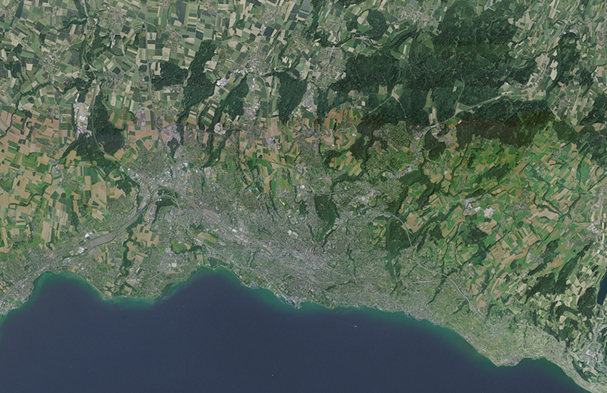
Das Mosaik der Landsat Satellitenbilder ist aus aus ca 20 einzelnen Aufnahmen des amerikanischen Satelliten Landsat 5, aus den Jahren 1990 bis 1994, zusammengesetzt. Es bildet einen flächendeckenden Bilddatensatz in natürlichen Farben und mit 25m Bodenauflösung.
La mosaïque Landsat est constituée d'environ 20 images individuelles, prises par le satellite américain Landsat 5, durant les années 1990 à 1994. Elle constitue un jeu de données image en couleurs naturelles, recouvrant l'ensemble de la Suisse, avec une résolution de 25m.
Il mosaico delle immagini satellitari Landsat è composto da circa 20 singole immagini riprese dal satellite americano Landsat 5 negli anni dal 1990 al 1994. Esso costituisce un set di dati immagine a colori naturali che copre tutto il territorio nazionale con una risoluzione al suolo di 25 metri.
The mosaic of Landsat satellite images is a composition of 20 individual images taken by the American satellite Landsat 5, in the years 1990 to 1994. It is a unique set of image data in natural colors, covering the whole territory of Switzerland in 25m resolution.
Il mosaic da las fotografias da satellit da Landsat sa cumpona da ca. 20 fotografias singulas dal satellit american Landsat 5 dals onns 1990 fin 1994. El furma ina unitad da datas fotografica en colurs natiralas e cun ina dissoluziun al fund da 25 m.
Simple
-
AlternativtitelAutres appellations ou acronymesTitolo alternativoAlternate titleAlternate title
-
Landsat Mosaik 25
Landsat Mosaique 25
Mosaico Landsat 25
Landsat Mosaic 25
Mosaic Landsat 25
-
Date (Publication)Data (Pubblicazione)Date (Publication)Date (Publication)Datumsangaben (Publikation)
- 1999-01-01
-
Date (Création)Data (Creazione)Date (Creation)Date (Creation)Datumsangaben (Erstellung)
- 1990-01-01T00:00:00
-
Date (lastRevision)Data (lastRevision)Date (lastRevision)Date (lastRevision)Datumsangaben (lastRevision)
- 1994-12-31T00:00:00
-
IdentificateurIdentificatoreCitation identifierCitation identifierIdentifikator
- ch.swisstopo.images-landsat25
-
Gemeinsamer TitelTitre collectifTitolo collettivo
-
Orthophotos (Landesvermessung)
Orthophotos (mensuration nationale)
Ortofoto (misurazione nazionale)
-
Zweck
-
Referenzdaten
-
EtatStatusStatusStatusBearbeitungsstatus
-
FinaliséCompletatoCompletedCompletedAbgeschlossen
- Point of contact
-
Organisation name Individual name Electronic mail address Role Bundesamt für Landestopografie swisstopo
Office fédéral de topographie swisstopo
Ufficio federale di topografia swisstopo
Federal Office of Topography swisstopo
Uffizi federal da topografia swisstopo
FournisseurFornitore della risorsaResource providerResource providerAnbieterBundesamt für Landestopografie swisstopo
Office fédéral de topographie swisstopo
Ufficio federale di topografia swisstopo
Federal Office of Topography swisstopo
Uffizi federal da topografia swisstopo
PropriétaireProprietarioOwnerOwnerEigentümer / Datenherr
-
Fréquence de mise à jourFrequenza di aggiornamentoMaintenance and update frequencyMaintenance and update frequencyÜberarbeitungsintervall
-
Non planifiéeNon pianificatoNot plannedNot plannedNicht geplant
- Resource format
-
Name Version GeoTIFF
-
-
geocat.ch
-
-
Geodaten
géodonnées
geodati
geodata
-
opendata.swiss
opendata.swiss
opendata.swiss
opendata.swiss
opendata.swiss
-
Aufbewahrungs- und Archivierungsplanung AAP - Bund
Planification de la conservation et de l'archivage AAP - Conféderation
Pianificazione della conservazione e dell’archiviazione AAP - Confederazione
Conservation and archiving planning AAP - Confederation
-
Geobasisdaten
géodonnées de base
geodati di base
official geodata
-
BGDI Bundesgeodaten-Infrastruktur
IFDG l’Infrastructure Fédérale de données géographiques
IFDG Infrastruttura federale dei dati geografici
FSDI Federal Spatial Data Infrastructure
-
-
GEMET
-
-
Satellitenbild
image satellite
immagine da satellite
satellite image
-
-
GEMET - INSPIRE themes, version 1.0
-
-
Orthofotografie
Ortho-imagerie
Orto immagini
Orthoimagery
-
-
Type de représentation spatialeTipo di rappresentazione spazialeSpatial representation typeSpatial representation typeRäumliche Darstellungsart
-
RasterDati rasterGridGridRaster, Gitter
-
Distance de résolutionDistanzaDistanceDistanceDistanz
- 25 m
-
Langue de la ressourceLingua dei datiLanguageLanguageSprache
- Deutsch
-
Encodage des caractèresSet dei caratteri dei datiCharacter setCharacter setZeichensatz
-
Utf8UTF8UTF8UTF8Utf8
-
Catégorie ISOTemaTopic categoryTopic categoryThematik
-
-
Carte de référence de la couverture terrestreMappe di baseImagery base maps earth coverImagery base maps earth coverOberflächenbeschreibung
-
Étendue
Estensione
Extent
Extent
Ausdehnung
-
BeschreibungDescriptionDescrizioneDescriptionDescription
-
Satellitenbilder (swisstopo)
Images satellites (swisstopo)
Immagini satellite (swisstopo)
Satellite images (swisstopo)
Satellitenbilder (swisstopo)
))

-
Identifiant géographiqueidentificatore GeograficoGeographic identifierGeographic identifierGeografischer Identifikator
-
satsatsatsatsat
-
Nom du système de référenceIdentificatore del sistema di riferimentoReference system identifierReference system identifierIdentifikator des Referenzsystems
-
Referenzsystem entsprechend der zugrundeliegenden topographischen Karte (CH1903)
-
DimensionsNumero delle dimensioniNumber of dimensionsNumber of dimensionsAnzahl der Dimensionen
- 2
-
Noms des axesNome dimensioneDimension nameDimension nameAchsenbezeichnung
-
Axe - XColonnaColumnColumnSpalte
-
Nombre de pixelMisura dimensioneDimension sizeDimension sizeElementanzahl
- 8750
-
RésolutionRisoluzioneResolutionResolutionAuflösung
- 5 m
-
Noms des axesNome dimensioneDimension nameDimension nameAchsenbezeichnung
-
Axe - YRigaRowRowZeile
-
Nombre de pixelMisura dimensioneDimension sizeDimension sizeElementanzahl
- 6000
-
RésolutionRisoluzioneResolutionResolutionAuflösung
- 5 m
-
Type de rasterGeometria della cellaCell geometryCell geometryZellengeometrie
-
SurfaceAreaAreaAreaFläche
-
Disponibilité des paramètres de transformationDisponibilità dei coefficienti della trasformazioneTransformation parameter availabilityTransformation parameter availabilityVerfügbarkeit von Transformationsparametern
- Distribution format
-
Name Version N/A
N/A
- OnLine resource
-
Protocol Linkage Name WWW:DOWNLOAD-URL
http://data.geo.admin.ch/ch.swisstopo.images-landsat25/data.zip OPENDATA:SWISS
https://opendata.swiss/de/perma/2c8e0a96-67ea-4a6d-86eb-88f8272e0639@bundesamt-fur-landestopografie-swisstopo Permalink opendata.swiss
Permalink opendata.swiss
Permalink opendata.swiss
Permalink opendata.swiss
OGC:WMS
https://wms.geo.admin.ch/?SERVICE=WMS&VERSION=1.3.0&REQUEST=GetCapabilities&lang=de ch.swisstopo.images-landsat25
ch.swisstopo.images-landsat25
ch.swisstopo.images-landsat25
ch.swisstopo.images-landsat25
ch.swisstopo.images-landsat25
-
NiveauLivelloHierarchy levelHierarchy levelBezugsebene
-
Jeu de donnéesDatasetDatasetDatasetDatenbestand
-
ErläuterungGénéralités sur la provenanceStatement
-
Mosaik von Landsat Satellitenbilder
mosaique d?image satellite Landsat
mosaic of Landsat satellite images
Information sur le contenu
Informazioni sul contenuto
Content Information
Content Information
Dateninhalt
Metadata
-
Identifiant de la ficheIdentificatore del file di metadatiFile identifierFile identifierMetadatensatzidentifikator
- 2c8e0a96-67ea-4a6d-86eb-88f8272e0639 XML
-
LangueLingua dei metadatiMetadata languageMetadata languageSprache
- Deutsch
-
Jeu de caractèresSet dei caratteri dei metadatiCharacter setCharacter setZeichensatz
-
Utf8UTF8UTF8UTF8Utf8
-
Type de ressourceLivello gerarchicoHierarchy levelHierarchy levelHierarchieebene
-
Jeu de donnéesDatasetDatasetDatasetDatenbestand
-
Date des métadonnéesData dei metadatiDate stampDate stampDatum
- 2023-04-24T12:52:05.587Z
- Metadata standard name
-
GM03 2+
- Metadata author
-
Organisation name Individual name Electronic mail address Role Bundesamt für Landestopografie swisstopo
Office fédéral de topographie swisstopo
Ufficio federale di topografia swisstopo
Federal Office of Topography swisstopo
Uffizi federal da topografia swisstopo
GestionnaireDepositarioCustodianCustodianVerwalter
- Other language
-
Language Character encoding FrançaisFranceseFrenchFrenchFranzösischUtf8UTF8UTF8UTF8Utf8ItalienItalianoItalianItalianItalienischUtf8UTF8UTF8UTF8Utf8AnglaisIngleseEnglishEnglishEnglischUtf8UTF8UTF8UTF8Utf8RomancheRomancioRomanshRomanshRätoromanischUtf8UTF8UTF8UTF8Utf8AllemandTedescoGermanGermanDeutschUtf8UTF8UTF8UTF8Utf8