INSPIRE Geoportal
Geothermische Karte der Schweiz 1:500000
Carte géothermique de la Suisse 1:500000
Carta geotermica svizzera 1:500000
Geothermal Map of Switzerland 1:500000
Charta geotermica da la Svizra 1:500000
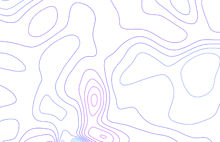
Die geothermische Karte zeigt die Wärmeenergie, die im Untergrund produziert wird und die durch einen 1 m2 an der Erdoberfläche fliesst. Die Wärme selbst wird grossenteils in der Erdkruste (ca. 30 km mächtig) durch radioaktive Zerfallsprozesse freigestellt. Im Mittel beträgt der Wärmefluss in der Schweiz ca. 90 mW/m2. Die Nordschweiz hat die höchste Werte und der Alpenraum/Jura hat die tiefste Werte. Abweichungen treten durch zirkulierende Tiefenwasser in durchlässigen Gesteinsschichten auf. Die Wärmefluss-Daten werden aus Temperaturgradient (Mittelwert ca. 30 K/km) und Wärmeleitfähigkeit der Gesteine (Mittelwert ca. 3 W/m/K) berechnet. - Papierkarte: PH. BODMER, 1982. - Bericht mit Aktualisierung: GP-30, F. MEDICI & L. RYBACH, 1995.
La carte géothermique rend compte de l’énergie thermique produite dans le sous-sol qui traverse 1 m2 de surface terrestre. Une grande partie de la chaleur est libérée par des processus de désintégration radioactive qui se déroulent dans la mince croûte terrestre (~30 km). En Suisse, le flux de chaleur moyen est ~90 mW/m2. Le flux de chaleur est le plus élevé dans le nord de la Suisse, et il est le plus faible dans l’arc alpin et dans le Jura. Les écartes sont généralement dus à des eaux souterraines qui circulent en profondeur dans des roches perméables. Les valeurs du flux de chaleur sont calculées à partir du gradient thermique (en moyenne ~30 K/km) et de la conductivité thermique des roches (en moyenne 3 W/m/K). - Carte papier: PH. BODMER, 1982. - Rapport avec mise à jour: GP-30, F. MEDICI & L. RYBACH, 1995.
La carta geotermica indica l'energia termica prodotta nel sottosuolo che attraversa 1 m2 di superficie terrestre. Il calore stesso viene liberato in buona parte nella crosta terrestre (spessa circa 30 km) attraverso un processo di disintegrazione radioattiva. In media il flusso di calore ammonta in Svizzera a circa 90mW/m2. La Svizzera settentrionale presenta i valori più elevati, le regioni delle Alpi e del Giura quelli più bassi. Gli scarti sono dovuti generalmente alla circolazione di flussi di acqua sotterranea attraverso strati di roccia permeabili. I valori del flusso di calore vengono calcolati in base al gradiente termico (in media circa 30 K/km) e alla conduttività termica delle rocce (in media circa 3 W/m/K). - Carta in formato cartaceo: PH. BODMER, 1982. - Rapporto con aggiornamento: GP-30, F. MEDICI & L. RYBACH, 1995.
The geothermal map shows the thermal energy that is produced in the subsurface and traverses the Earth's surface within an area of 1 m2. The heat itself is released in the Earth's crust (around 30 km thick) generally by radioactive decay processes. On average, the heat flow in Switzerland is around 90 mW/m2. The highest figures are found in northern Switzerland and the lowest in the Alps/Jura. Differences are caused by deep groundwater circulating in permeable rock strata. The heat flow data is calculated from the temperature gradient (average value approx. 30 K/km) and heat conductivity of the rock (average value approx. 3 W/m/K). - Paper map: PH. BODMER, 1982. - Report with update: GP-30, F. MEDICI & L. RYBACH, 1995.
La charta geotermica mussa l'energia termica che vegn producida en il sutterren e che cula tras 1 m2 da la surfatscha da la terra. La chalur sezza vegn deliberada per gronda part en la crusta da la terra (grossezza: ca. 30 km) tras process da decumposiziun radioactivs. En media importa il fluss da chalur en Svizra ca. 90 mW/m2. Las valurs las pli grondas chattan ins en la Svizra dal nord, las valurs las pli pitschnas en il territori alpin/Giura. Divergenzas datti tras auas sutterranas che circuleschan en stresas da crappa permeablas. Las datas che pertutgan il fluss da chalur vegnan calculadas dal gradient termic (valur media ca. 30 K/km) e da la conductivitad termica da la crappa (valur media ca. 3 W/m/K). - Charta da palpiri: PH. BODMER, 1982. - Update: GP-30, F. MEDICI & L. RYBACH, 1995.
Simple
-
AlternativtitelAutres appellations ou acronymesTitolo alternativoAlternate titleAlternate title
-
Wärmestromdichte 500
Densité de flux thermique 500
Densità di flusso termico 500
Heat flux 500
Densitad dal fluss da chalur 500
-
Date (Publication)Data (Pubblicazione)Date (Publication)Date (Publication)Datumsangaben (Publikation)
- 1982-12-31
-
IdentificateurIdentificatoreCitation identifierCitation identifierIdentifikator
- ch.swisstopo.geologie-geophysik-geothermie
Identificateur
Identificatore
Citation identifier
Citation identifier
Identifikator
-
Weitere InformationenAutres informations de référence
-
Siehe auch Publikation Nr. 30 der Schweizerischen Geophysikalischen Kommission.
Voir aussi Publication No 30 de la Commission suisse de géophysique.
-
Gemeinsamer TitelTitre collectifTitolo collettivoCollective title
-
Geophysikalisches Kartenwerk
Cartes géophysiques
Carte geofisiche
Geophysical maps
-
ZweckBut
-
Übersicht über die Geothermie in der Schweiz
Vue d’ensemble de la géothermie en Suisse
-
EtatStatusStatusStatusBearbeitungsstatus
-
FinaliséCompletatoCompletedCompletedAbgeschlossen
- Point of contact
-
Organisation name Individual name Electronic mail address Role Schweizerische Geophysikalische Kommission
Commission suisse de géophysique
Swiss Geophysical Commission
Swiss Geophysical Commission
kiss@tomo.ig kiss@tomo.ig.erdw.ethz.ch
A l’origine deIdeatoreOriginatorOriginatorUrheberBundesamt für Landestopografie swisstopo
Office fédéral de topographie swisstopo
Ufficio federale di topografia swisstopo
Federal Office of Topography swisstopo
Uffizi federal da topografia swisstopo
Point de contactPunto di contattoPoint of contactPoint of contactAnsprechpartnerBundesamt für Landestopografie swisstopo
Office fédéral de topographie swisstopo
Ufficio federale di topografia swisstopo
Federal Office of Topography swisstopo
Uffizi federal da topografia swisstopo
PropriétaireProprietarioOwnerOwnerEigentümer / Datenherr
-
Fréquence de mise à jourFrequenza di aggiornamentoMaintenance and update frequencyMaintenance and update frequencyÜberarbeitungsintervall
-
IrrégulièreIrregolareIrregularIrregularUnregelmässig
-
geocat.ch
-
-
opendata.swiss
opendata.swiss
opendata.swiss
opendata.swiss
opendata.swiss
-
Geobasisdaten
géodonnées de base
geodati di base
official geodata
-
Aufbewahrungs- und Archivierungsplanung AAP - Bund
Planification de la conservation et de l'archivage AAP - Conféderation
Pianificazione della conservazione e dell’archiviazione AAP - Confederazione
Conservation and archiving planning AAP - Confederation
-
e-geo.ch
e-geo.ch
e-geo.ch
e-geo.ch
-
Geophysikalische Karte
carte géophysique
carta geofisica
geophysical map
-
EGIP (European Geothermal Information Platform)
EGIP (European Geothermal Information Platform)
EGIP (European Geothermal Information Platform)
EGIP (European Geothermal Information Platform)
-
-
GEMET
-
-
Erdwärme
énergie géothermique
energia geotermica
geothermal energy
-
Geophysik
géophysique
geofisica
geophysics
-
-
GEMET - INSPIRE themes, version 1.0
-
-
Energiequellen
Sources d'énergie
Risorse energetiche
Energy resources
-
Geologie
Géologie
Geologia
Geology
-
-
geocat.ch
-
-
BGDI Bundesgeodaten-Infrastruktur
IFDG l’Infrastructure Fédérale de données géographiques
IFDG Infrastruttura federale dei dati geografici
FSDI Federal Spatial Data Infrastructure
-
-
Type de représentation spatialeTipo di rappresentazione spazialeSpatial representation typeSpatial representation typeRäumliche Darstellungsart
-
VecteurDati vettorialiVectorVectorVektor
-
Dénominateur de l'échelleDenominatoreDenominatorDenominatorMassstabszahl
- 500000
-
Langue de la ressourceLingua dei datiLanguageLanguageSprache
- Deutsch
-
Langue de la ressourceLingua dei datiLanguageLanguageSprache
- Français
-
Langue de la ressourceLingua dei datiLanguageLanguageSprache
- Italiano
-
Langue de la ressourceLingua dei datiLanguageLanguageSprache
- English
-
Encodage des caractèresSet dei caratteri dei datiCharacter setCharacter setZeichensatz
-
Utf8UTF8UTF8UTF8Utf8
-
Catégorie ISOTemaTopic categoryTopic categoryThematik
-
-
Sciences de la terre, géosciencesInformazioni geoscientificheGeoscientific informationGeoscientific informationGeowissenschaften
-
Étendue
Estensione
Extent
Extent
Ausdehnung
-
BeschreibungDescriptionDescrizioneDescriptionDescription
-
Landeskarte 1:500'000
Carte nationale 1:500'000
Carta nazionale 1:500'000
National Map 1:500'000
Landeskarte 1:500'000
))

-
Identifiant géographiqueidentificatore GeograficoGeographic identifierGeographic identifierGeografischer Identifikator
-
LK500CN500CN500NM500LK500
-
Nom du système de référenceIdentificatore del sistema di riferimentoReference system identifierReference system identifierIdentifikator des Referenzsystems
-
Referenzsystem entsprechend der zugrundeliegenden topographischen Karte (CH1903)Système de référence conformément à la carte topographique sous-jacente (CH1903)
- Distribution format
-
Name Version ESRI Shapefile
-
- OnLine resource
-
Protocol Linkage Name MAP:Preview
https://map.geo.admin.ch/?layers=ch.swisstopo.geologie-geophysik-geothermie Vorschau map.geo.admin.ch
Aperçu map.geo.admin.ch
Previsione map.geo.admin.ch
Preview map.geo.admin.ch
OGC:WMS
https://wms.geo.admin.ch/?SERVICE=WMS&VERSION=1.3.0&REQUEST=GetCapabilities&lang=de ch.swisstopo.geologie-geophysik-geothermie
ch.swisstopo.geologie-geophysik-geothermie
ch.swisstopo.geologie-geophysik-geothermie
ch.swisstopo.geologie-geophysik-geothermie
ch.swisstopo.geologie-geophysik-geothermie
OGC:WMTS
https://wmts.geo.admin.ch/EPSG/3857/1.0.0/WMTSCapabilities.xml?lang=de ch.swisstopo.geologie-geophysik-geothermie
ch.swisstopo.geologie-geophysik-geothermie
ch.swisstopo.geologie-geophysik-geothermie
ch.swisstopo.geologie-geophysik-geothermie
ch.swisstopo.geologie-geophysik-geothermie
- OnLine resource
-
Protocol Linkage Name WWW:LINK
https://shop.swisstopo.admin.ch/de/buecher-und-publikationen/landesgeologie/beitraege-zur-geologie-der-schweiz/serie-geophysik Produkte- und Bestellinformationen
Infos sur le produit et les possibilités de commande
Informazioni sul prodotto e opzioni di ordinazione
Product information and ordering options
WWW:DOWNLOAD-URL
https://data.geo.admin.ch/ch.swisstopo.geologie-geophysik-geothermie Download (data.geo.admin.ch)
Téléchargement (data.geo.admin.ch)
Download (data.geo.admin.ch)
Download (data.geo.admin.ch)
CHTOPO:specialised-geoportal
https://map.geo.admin.ch/?topic=geothermie&lang=de Thema Geothermie (map.geo.admin.ch)
Thème Géothermie (map.geo.admin.ch)
Tema Geotermia (map.geo.admin.ch)
Topic Geoth. energy (map.geo.admin.ch)
WWW:LINK
http://www.sgpk.ethz.ch/ Schweiz. Geophysikalische Kommission SGPK
Commission suisse de géophysique SGPK
Commissione svizzera di geofisica SGPK
Swiss Geophysical Commission SGPK
WWW:LINK
https://www.geologieportal.ch/de/themen/energie/geothermie.html Geologie-Portal: Geothermie
Portail géologique: Géothermie
Portale Geologico: Geotermia
Geology Portal: Geothermal energy
ESRI:REST
https://api3.geo.admin.ch/rest/services/api/MapServer/ch.swisstopo.geologie-geophysik-geothermie RESTful API von geo.admin.ch
RESTful API de geo.admin.ch
RESTful API da geo.admin.ch
RESTful API from geo.admin.ch
RESTful API dad geo.admin.ch
OPENDATA:SWISS
https://opendata.swiss/de/perma/2d8174b2-8c4a-44ea-b470-cb3f216b90d1@bundesamt-fur-landestopografie-swisstopo Permalink opendata.swiss
Permalink opendata.swiss
Permalink opendata.swiss
Permalink opendata.swiss
-
NiveauLivelloHierarchy levelHierarchy levelBezugsebene
-
Jeu de donnéesDatasetDatasetDatasetDatenbestand
-
ErläuterungGénéralités sur la provenance
-
Diese Karte stellt vor dem Hintergrund der Landeskarte 1:500'000 und der Tektonischen Karte 1:500'000 die terrestrische Wärmeenergie dar.
Cette carte représente l'énergie calorifique terrestre sur le fond de la Carte nationale 1:500’000 et de la Carte tectonique 1:500’000.
Metadata
-
Identifiant de la ficheIdentificatore del file di metadatiFile identifierFile identifierMetadatensatzidentifikator
- 2d8174b2-8c4a-44ea-b470-cb3f216b90d1 XML
-
LangueLingua dei metadatiMetadata languageMetadata languageSprache
- Deutsch
-
Jeu de caractèresSet dei caratteri dei metadatiCharacter setCharacter setZeichensatz
-
Utf8UTF8UTF8UTF8Utf8
-
Type de ressourceLivello gerarchicoHierarchy levelHierarchy levelHierarchieebene
-
Jeu de donnéesDatasetDatasetDatasetDatenbestand
-
Date des métadonnéesData dei metadatiDate stampDate stampDatum
- 2022-04-06T06:37:35Z
- Metadata standard name
-
GM03 2+
- Metadata author
-
Organisation name Individual name Electronic mail address Role Bundesamt für Landestopografie swisstopo
Office fédéral de topographie swisstopo
Ufficio federale di topografia swisstopo
Federal Office of Topography swisstopo
Uffizi federal da topografia swisstopo
Point de contactPunto di contattoPoint of contactPoint of contactAnsprechpartner
- Other language
-
Language Character encoding FrançaisFranceseFrenchFrenchFranzösischUtf8UTF8UTF8UTF8Utf8ItalienItalianoItalianItalianItalienischUtf8UTF8UTF8UTF8Utf8AnglaisIngleseEnglishEnglishEnglischUtf8UTF8UTF8UTF8Utf8RomancheRomancioRomanshRomanshRätoromanischUtf8UTF8UTF8UTF8Utf8AllemandTedescoGermanGermanDeutschUtf8UTF8UTF8UTF8Utf8