INSPIRE Geoportal
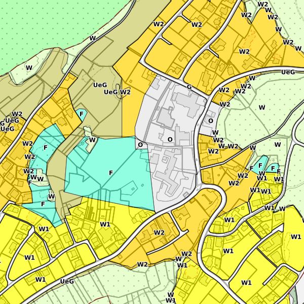
Zonenplan der Gemeinde Schellenberg
Der Zonenplan Schellenberg wird gemäss Baugesetz, Art. 12, hauptsächlich aus den vier digitalen Themen Grundnutzungsflächen, Schutzobjekte, Planungsinstrumente sowie Abbau/Deponie erstellt. Er bildet das gesamte Gemeindegebeit ab. Für Kontrollzwecke kann der rechtsgültige Zonenplan mit weiteren überlangernden Themen sowie mit Bauordnung bei der Gemeinde bezogen bzw. auf deren Startseite heruntergeladen werden.
Simple
- Alternate title
-
Zonenplan Schellenberg
- Date (Publication)
- 2011-11-29
- Citation identifier
- https://metadata.geo.llv.li/308bbb89-f787-4633-9c37-e0f10aad8fcf
- Purpose
-
Digitale Planungsgrundlage
- Status
- Completed
- Point of contact
-
Organisation name Individual name Electronic mail address Role Gemeinde Schellenberg
Point of contact
- Maintenance and update frequency
- As needed
- Resource format
-
Name Version INTERLIS 1 (ITF)
-
GEMET
-
-
vector
-
-
GEMET - INSPIRE themes, version 1.0
-
-
Land use
-
Protected sites
-
-
geocat.ch
-
-
INSPIRE
-
primary use
-
development plan
-
construction zone
-
zone
-
-
Spatial scope
-
-
Local
-
-
GEMET
-
-
construction waste
-
- Use limitation
-
gebührenpflichtig
- Access constraints
- Other restrictions
- Use constraints
- Other restrictions
- Other constraints
- Subject to a fee.
- Use limitation
-
keine
- Access constraints
- Other restrictions
- Use constraints
- Other restrictions
- Other constraints
- Subject to a fee.
- Spatial representation type
- Vector
- Denominator
- 500
- Language
- Deutsch
- Character set
- UTF8
- Topic category
-
- Planning cadastre
Extent
- Description
-
Schellenberg FL
))

- Geographic identifier
- Schellenberg
- Reference system identifier
- http://www.opengis.net/def/crs/EPSG/0/2056
- Reference system identifier
- http://www.opengis.net/def/crs/EPSG/0/4936
- Topology level
- Full planar graph
- Geometric object type
- Surface
- Geometric object count
- 1426
- Distribution format
-
Name Version INTERLIS 1 (ITF)
AutoCAD DXF (DXF)
ESRI Shapefile (SHP)
- Distributor contact
-
Organisation name Individual name Electronic mail address Role Surveying and Geoinformation Division
Point of contact
- Distributor contact
-
Organisation name Individual name Electronic mail address Role Gemeinde Schellenberg
Point of contact
- OnLine resource
-
Protocol Linkage Name WWW:LINK
https://www.schellenberg.li Gemeinde Schellenberg
WWW:LINK
https://www.llv.li/inhalt/1627/amtsstellen/datenausgabe Startseite ABI, Datenausgabestelle
- Hierarchy level
- Dataset
Conformance result
- Date (Publication)
- 2010-12-08
- Explanation
-
Gemäss INSPIRE Bestandteil der Themen "Schutzgebiete", "Bodennutzung" sowie "Versorgungswirtchaft und staatliche Dienste"
- Pass
- No
- Statement
-
Konstruktion auf der Grundlage der Amtlichen Vermessung
- Included with dataset
- No
- Date (Revision)
- 2015-01-29
Metadata
- File identifier
- 308bbb89-f787-4633-9c37-e0f10aad8fcf XML
- Metadata language
- Deutsch
- Character set
- UTF8
- Hierarchy level
- Dataset
- Date stamp
- 2023-03-07T13:56:04.655Z
- Metadata standard name
-
GM03 2+
- Metadata author
-
Organisation name Individual name Electronic mail address Role Surveying and Geoinformation Division
Point of contact
- Other language
-
Language Character encoding French UTF8 Italian UTF8 English UTF8 German UTF8