 INSPIRE Geoportal
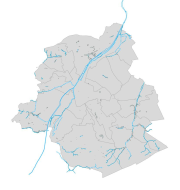
INSPIRE - Hydrographie
INSPIRE - Hydrografie
INSPIRE - Hydrography
Région de Bruxelles-Capitale : Jeu de données comprenant le réseau hydrographique, les sous bassins versant et les eaux de surface de la Région de Bruxelles capitale. Le jeu de données est présenté sous forme de GML conforme aux exigences de la directive européenne INSPIRE.
Brussels Hoofdstedelijk Gewest: Dataset bestaande uit het riviernetwerk, stroomgebieden en oppervlaktewateren van de hoofdstad van de hoofdstad van Brussel. De dataset wordt gepresenteerd in de vorm van GML in overeenstemming met de vereisten van de Europese richtlijn INSPIRE.
Brussels-Capital Region: Dataset including the watercourse network, drainage bassin and surface waters of the Brussels capital Region. The dataset is presented as a GML compliant with the requirements of the European INSPIRE directive.
Simple
-
Datum (publicatie)Date (Publication)Date (Publication)
- 2017-12-22
-
Datum (revisie)Date (Revision)Date (Révision)
- 2017-12-22
-
Datum (creatie)Date (Creation)Date (Création)
- 2017-12-22
-
IdentifierCitation identifierIdentificateur
- BE.BELB / BRU_ENVI_4da44671-0141-4dcd-a03a-87fc00733ba9
- Point of contact
-
Organisation name Individual name Electronic mail address Role Bruxelles EnvironnementLeefmilieu BrusselBrussels Environmentgeodata@environnement.bru geodata@environnement.brussels
contactpuntPoint of contactPoint de contactBruxelles EnvironnementLeefmilieu BrusselBrussels Environmentgeodata@environnement.bru geodata@environnement.brussels
contactpuntPoint of contactPoint de contact
-
HerzieningsfrequentieMaintenance and update frequencyFréquence de mise à jour
-
indien nodigAs neededLorsque nécessaire
-
GeoBru Administrative Regions
-
-
Belgique
België
Belgium
-
Région de Bruxelles-Capitale
Brussels Hoofdstedelijk Gewest
Région de Bruxelles-Capitale
-
-
GEMET - Themes, version 4.2.3GEMET - Themes, version 4.2.3GEMET - Themes, version 4.2.3
-
-
occupation du sollandgebruikland occupation
-
eau de surfaceoppervlaktewatersurface water
-
environnementmilieuenvironment
-
hydrographiehydrografiehydrography
-
réseau hydrographiquehydrografisch netwerkhydrographic network
-
gestion des ressources en eaubeheer van de waterbronnenwater resources management
-
-
GeoBru brussels keywords
-
-
Maillage bleu
Blauw netwerk
Blue Network
-
Reporting Inspire
Reporting Inspire
Reporting Inspire
-
-
INSPIRE feature concept dictionary
-
-
Franchissement entre deux cours d'eau
Waterloop gescheiden kruising
Watercourse Separated Crossing
-
Eaux stagnantes
Stilstaand water
Standing Water
-
Séquence de tronçons de cours d'eau
Waterlooplinksequentie
Watercourse Link Sequence
-
Séquence de tronçons de cours d'eau
Waterlooplinksequentie
Watercourse Link Sequence
-
Bassin versant
Afwateringsgebied
Drainage Basin
-
-
Champ géographiqueRuimtelijke dekkingSpatial scope
-
-
Régional
Regionaal
Regional
-
-
(Juridische) toegangsrestrictieAccess constraintsContraintes d'accès
-
andersOther restrictionsAutres restrictions
-
Autres contraintesOverige beperkingenOther constraints
-
Pas de restriction concernant l'accès publicGeen beperkingen op openbare toegangNo limitations to public access
-
(Juridische) gebruiksbeperkingUse constraintsContraintes d'utilisation
-
andersOther restrictionsAutres restrictions
-
Ruimtelijk schemaSpatial representation typeType de représentation spatiale
-
vectorVectorVecteur
-
ToepassingsschaalDenominatorDénominateur de l'échelle
- 500
-
TaalLanguageLangue de la ressource
- Français
-
OnderwerpTopic categoryCatégorie ISO
-
-
binnenwaterInland watersEaux intérieures, Hydrographie
-
))
- gml32:beginPosition
- 2002-01-01
- gml32:endPosition
- 2020-12-31
-
CodeCodeUnique resource identifier
-
EPSG:3035EPSG:3035EPSG:3035
- Distribution format
-
Name Version GMLGMLGML
- Units of distribution
-
MB
-
Bestands grootteTransfer sizeTaille de transfert
- 0.5
- OnLine resource
-
Protocol Linkage Name WWW:DOWNLOAD-1.0-http--download
https://wfs.environnement.brussels/belb_inspire_hydrography?VERSION=2.0.0&SERVICE=wfs&REQUEST=GetFeature&Language=eng&OUTPUTFORMAT=text/xml;%20subtype=gml/3.2.1&typenames=ms:HY.PhysicalWaters.Catchments ms:HY.PhysicalWaters.Catchments WWW:DOWNLOAD-1.0-http--download
https://wfs.environnement.brussels/belb_inspire_hydrography?VERSION=2.0.0&SERVICE=wfs&REQUEST=GetFeature&Language=eng&OUTPUTFORMAT=text/xml;%20subtype=gml/3.2.1&typenames=ms:HY.PhysicalWaters.Waterbodies.StandingWater ms:HY.PhysicalWaters.Waterbodies.StandingWater
- OnLine resource
-
Protocol Linkage Name OGC:WMS
https://wms.environnement.brussels/belb_inspire_hydrography?SERVICE=wms&REQUEST=GetCapabilities&version=1.3.0 HY.Network
HY.Network
HY.Network
- OnLine resource
-
Protocol Linkage Name OGC:WMS
https://wms.environnement.brussels/belb_inspire_hydrography?SERVICE=wms&REQUEST=GetCapabilities&version=1.3.0 HY.PhysicalWaters.Waterbodies.Watercourse
HY.PhysicalWaters.Waterbodies.Watercourse
HY.PhysicalWaters.Waterbodies.Watercourse
- OnLine resource
-
Protocol Linkage Name OGC:WMS
https://wms.environnement.brussels/belb_inspire_hydrography?SERVICE=wms&REQUEST=GetCapabilities&version=1.3.0 HY.PhysicalWaters.Waterbodies.StandingWater
HY.PhysicalWaters.Waterbodies.StandingWater
HY.PhysicalWaters.Waterbodies.StandingWater
- OnLine resource
-
Protocol Linkage Name OGC:WMS
https://wms.environnement.brussels/belb_inspire_hydrography?SERVICE=wms&REQUEST=GetCapabilities&version=1.3.0 HY.PhysicalWaters.Catchments
HY.PhysicalWaters.Catchments
HY.PhysicalWaters.Catchments
-
Niveau kwaliteitsbeschrijvingHierarchy levelNiveau
-
datasetDatasetJeu de données
Resultaat conformiteit met de specificatie
Conformance result
Résultat de conformité
-
Datum (publicatie)Date (Publication)Date (Publication)
- 2010-12-08
-
ExplicationUitlegExplanation
-
Le jeu de données répond aux exigences minimales prédécrites
De dataset volgt de minimale vereissen
The dataset does fullfill the minimal requirements
-
Indicatie van conformiteit met de specificatiePassDegré de conformité
- Yes
-
Généralités sur la provenance
-
Bruxelles Environnement / Leefmilieu Brussel
Metadata
-
Metadata IDFile identifierIdentifiant de la fiche
- 4da44671-0141-4dcd-a03a-87fc00733ba9 XML
-
TaalMetadata languageLangue
- Français
-
Hierarchisch niveauHierarchy levelType de ressource
-
datasetDatasetJeu de données
-
Metadata datumDate stampDate des métadonnées
- 2024-02-08T13:26:48
- Metadata standard name
-
ISO19115
- Metadata standard version
-
2003/Cor.1:2006
- Metadata author
-
Organisation name Individual name Electronic mail address Role Bruxelles EnvironnementLeefmilieu BrusselBrussels Environmentgeodata@environnement.bru geodata@environnement.brussels
contactpuntPoint of contactPoint de contact
- Other language
-
Language Character encoding Nederlands; VlaamsDutch; FlemishNéerlandais; flamandutf8UTF8Utf8EngelsEnglishAnglaisutf8UTF8Utf8FransFrenchFrançaisutf8UTF8Utf8
Overviews

Spatial extent
Provided by
