INSPIRE Geoportal
Vektorielle Kartenbasis (Vector Tileset)
Base cartographique vectorielle (Vector Tileset)
Base cartografica vettoriale (Vector Tileset)
Vector map base (Vector Tileset)
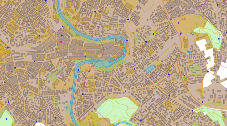
Das Base Vector Tileset ist ein Paket von vordefinierten und gekachelten vektoriellen Kartendaten. Sie dienen als Quelle für dynamische Web-Kartendarstellungen (vgl. BaseMap Vector Tile Style). Der Inhalt des Base Vector Tilesets ist für einzelne Zoomstufen kartografisch angepasst und für die mobile Nutzung optimiert. Integrierter Bestandteil sind Point-of-Interest zu verschiedenen Themenbereichen. Neben amtlichen Daten (u.a. topografisches Landschaftsmodell, digitales kartografisches Modell, Haltestellen des öffentlichen Verkehrs und amtliches Verzeichnis der Strassen) bilden Daten Dritter die Grundlage. Das Base Vector Tileset basiert auf der Mapbox Vector Tiles Spezifikation und ist nach dem OpenMapTiles Schema strukturiert. Die Daten umfassen die Schweiz und das Fürstentum Liechtenstein.
Le Base Vector Tileset est un ensemble de données cartographiques vectorielles prédéfinies et carrelées. Elles servent de source pour des représentations cartographiques dynamiques sur le web (cf. BaseMap Vector Tile Style). Le contenu du Base Vector Tileset est adapté cartographiquement aux différents niveaux de zoom et optimisé pour une utilisation mobile. Des points d'intérêt sur différents thèmes en font partie intégrante. Outre les données officielles (notamment le modèle topographique du paysage, le modèle cartographique numérique, les arrêts des transports publics et le répertoire officiel des rues), des données de tiers constituent la base. Le Base Vector Tileset est basé sur la spécification Mapbox Vector Tiles et il est structuré selon le schéma OpenMapTiles. Les données couvrent la Suisse et la Principauté de Liechtenstein.
Il Base Vector Tileset è un pacchetto di dati cartografici vettoriali predefiniti e affiancati. Servono come fonte per la visualizzazione di mappe web dinamiche (cfr. BaseMap Vector Tile Style). Il contenuto del Base Vector Tileset è adattato cartograficamente ai singoli livelli di zoom e ottimizzato per l'uso mobile. I punti di interesse su vari argomenti sono una componente integrata. Oltre ai dati ufficiali (tra cui il modello topografico del paesaggio, il modello cartografico digitale, le fermate dei trasporti pubblici e l’elenco ufficiale delle strade) la base è costituita da dati di terzi. Il set di piastrelle vettoriali di base si fonda sulla specifica Mapbox Vector Tiles ed è strutturato secondo lo schema OpenMapTiles. I dati coprono la Svizzera e il Principato del Liechtenstein.
The Base Vector Tileset is a comprehensive package of tiled vector map data designed to be used as a source for dynamic web map representation, specifically the BaseMap Vector Tile Style. The content of the Base Vector tileset is cartographically adapted for each zoom level and optimised for mobile usage. It includes integrated POIs’ on various topics in addition to official data, such as the topographic landscape model, digital cartographic model, public transport stops and the official road directory. Likewise, third party data is integrated. The Base Vector Tileset adheres to the Mapbox Vector Tiles specification and follows the OpenMapTiles schema. The data covers Switzerland and the Principality of Liechtenstein.
Simple
-
AlternativtitelAutres appellations ou acronymesTitolo alternativoAlternate titleAlternate title
-
Basis Vector Tileset
Base Vector Tileset
Base Vector Tileset
Base Vector Tileset
Basa Vector Tileset
-
Date (Création)Data (Creazione)Date (Creation)Date (Creation)Datumsangaben (Erstellung)
- 2023-07-01
-
Date (Publication)Data (Pubblicazione)Date (Publication)Date (Publication)Datumsangaben (Publikation)
- 2023-10-01
- Edition
-
1.0.0
-
IdentificateurIdentificatoreCitation identifierCitation identifierIdentifikator
- ch.swisstopo.base.vt
Identificateur
Identificatore
Citation identifier
Citation identifier
Identifikator
-
Gemeinsamer TitelTitre collectifTitolo collettivoCollective title
-
Landesvermessung
mensuration nationale
misurazione nazionale
National survey
-
EtatStatusStatusStatusBearbeitungsstatus
-
Mise à jour continueIn corsoOn goingOn goingKontinuierliche Aktualisierung
- Point of contact
-
Organisation name Individual name Electronic mail address Role Bundesamt für Landestopografie swisstopo
Office fédéral de topographie swisstopo
Ufficio federale di topografia swisstopo
Federal Office of Topography swisstopo
Uffizi federal da topografia swisstopo
Point de contactPunto di contattoPoint of contactPoint of contactAnsprechpartnerBundesamt für Landestopografie swisstopo
Office fédéral de topographie swisstopo
Ufficio federale di topografia swisstopo
Federal Office of Topography swisstopo
Uffizi federal da topografia swisstopo
PropriétaireProprietarioOwnerOwnerEigentümer / Datenherr
-
Fréquence de mise à jourFrequenza di aggiornamentoMaintenance and update frequencyMaintenance and update frequencyÜberarbeitungsintervall
-
AnnuelleAnnualeAnnuallyAnnuallyJährlich
-
geocat.ch
-
-
Geobasisdaten
géodonnées de base
geodati di base
official geodata
-
Basiskarte
carte de base
carta di base
base map
-
BGDI Bundesgeodaten-Infrastruktur
IFDG l’Infrastructure Fédérale de données géographiques
IFDG Infrastruttura federale dei dati geografici
FSDI Federal Spatial Data Infrastructure
-
-
GEMET - INSPIRE themes, version 1.0
-
-
Geografische Bezeichnungen
Dénominations géographiques
Nomi geografici
Geographical names
-
-
Contraintes d'utilisationVincoli di fruibilitàUse constraintsUse constraintsNutzungseinschränkungen
-
Autres restrictionsAltri vincoliOther restrictionsOther restrictionsBenutzerdefinierte Einschränkungen
-
Andere EinschränkungenAutres contraintesAltri vincoliOther constraints
-
Opendata BY: Freie Nutzung. Quellenangabe ist Pflicht.Opendata BY: Utilisation libre. Obligation d’indiquer la source.Opendata BY: Libero utilizzo. Indicazione della fonte obbligatoria.Opendata BY: Open use. Must provide the source.
-
Andere EinschränkungenAutres contraintesAltri vincoliOther constraints
-
Allgemeine Nutzungsbedingungen der Bundes Geodaten-Infrastruktur BGDIConditions générales d’utilisation et d’exploitation de l’Infrastructure fédérale de données géographiques IFDGCondizioni generali di utilizzo e disposizioni operative dell’infrastruttura federale di dati geografici (IFDG)General Terms of Use and Operating Conditions of the Federal Spatial Data Infrastructure FSDI
-
Type de représentation spatialeTipo di rappresentazione spazialeSpatial representation typeSpatial representation typeRäumliche Darstellungsart
-
VecteurDati vettorialiVectorVectorVektor
-
Dénominateur de l'échelleDenominatoreDenominatorDenominatorMassstabszahl
- 5000
-
Dénominateur de l'échelleDenominatoreDenominatorDenominatorMassstabszahl
- 1000000
-
Langue de la ressourceLingua dei datiLanguageLanguageSprache
- English
-
Encodage des caractèresSet dei caratteri dei datiCharacter setCharacter setZeichensatz
-
Utf8UTF8UTF8UTF8Utf8
-
Catégorie ISOTemaTopic categoryTopic categoryThematik
-
-
Carte de référence de la couverture terrestreMappe di baseImagery base maps earth coverImagery base maps earth coverOberflächenbeschreibung
-
Étendue
Estensione
Extent
Extent
Ausdehnung
-
BeschreibungDescriptionDescrizioneDescriptionDescription
-
Schweiz
Suisse
Svizzera
Switzerland
Svizra
))

Étendue
Estensione
Extent
Extent
Ausdehnung
-
BeschreibungDescriptionDescrizioneDescriptionDescription
-
Liechtenstein
Liechtenstein
Liechtenstein
Liechtenstein
Liechtenstein
))

-
Nom du système de référenceIdentificatore del sistema di riferimentoReference system identifierReference system identifierIdentifikator des Referenzsystems
-
EPSG:3857EPSG:3857EPSG:3857EPSG:3857
- Distribution format
-
Name Version Mapbox GL JS
-
- OnLine resource
-
Protocol Linkage Name WWW:LINK
https://www.swisstopo.admin.ch/de/geodata/maps/smw.html WWW:LINK
https://www.geo.admin.ch/de/geo-dienstleistungen/geodienste/darstellungsdienste-webmapping-webgis-anwendungen/vector_tiles_service.html Web Service description
WWW:LINK
https://api3.geo.admin.ch/services/sdiservices.html#mapbox-vector-tiles
Metadata
-
Identifiant de la ficheIdentificatore del file di metadatiFile identifierFile identifierMetadatensatzidentifikator
- 4f0a9bae-2581-49fa-99cc-50f1fb5f2c82 XML
-
LangueLingua dei metadatiMetadata languageMetadata languageSprache
- Deutsch
-
Jeu de caractèresSet dei caratteri dei metadatiCharacter setCharacter setZeichensatz
-
Utf8UTF8UTF8UTF8Utf8
-
Type de ressourceLivello gerarchicoHierarchy levelHierarchy levelHierarchieebene
-
Jeu de donnéesDatasetDatasetDatasetDatenbestand
-
Date des métadonnéesData dei metadatiDate stampDate stampDatum
- 2023-09-12T08:15:12.987Z
- Metadata standard name
-
GM03 2+
- Metadata author
-
Organisation name Individual name Electronic mail address Role Bundesamt für Landestopografie swisstopo
Office fédéral de topographie swisstopo
Ufficio federale di topografia swisstopo
Federal Office of Topography swisstopo
Uffizi federal da topografia swisstopo
Point de contactPunto di contattoPoint of contactPoint of contactAnsprechpartner
- Other language
-
Language Character encoding FrançaisFranceseFrenchFrenchFranzösischUtf8UTF8UTF8UTF8Utf8ItalienItalianoItalianItalianItalienischUtf8UTF8UTF8UTF8Utf8AnglaisIngleseEnglishEnglishEnglischUtf8UTF8UTF8UTF8Utf8RomancheRomancioRomanshRomanshRätoromanischUtf8UTF8UTF8UTF8Utf8AllemandTedescoGermanGermanDeutschUtf8UTF8UTF8UTF8Utf8