 INSPIRE Geoportal
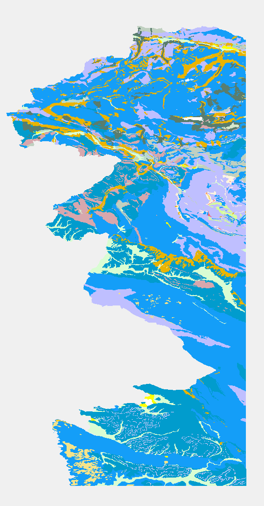
eENVplus GeoZS 100k Geološka karta
The Basic Geological Map of Slovenia as a part of joint Basic Geological Map of SFR Yugoslavia presents lithological and stratigraphic characteristics of rocks, their relationships, age and other. It is a key to the understanding of the geology of Slovenia. It consists of 23 sheets at a scale of 1: 100,000.
Simple
-
Date (Publication)
- 2015-01-01
-
Date (Revision)
- 2015-01-01
-
Date (Creation)
- 2015-01-01
-
Citation identifier
- SI.GEOZS.EENVPLUS.100K.GU / 2ae26402-e7e6-4e62-85d3-aeef544c8080
- Point of contact
-
Organisation name Individual name Electronic mail address Role Geological Survey of Slovenia
info@geo-zs.si
OwnerGeological Survey of Slovenia
dr. Matevž Novak
matevz.novak@geo-zs.si
Point of contactGeološki zavod Slovenije
info@geo-zs.si
Custodian
-
ThIST - Italian Thesaurus of Earth Sciences (Version: Linked Data 1.0)
-
-
construction materials
-
sedimentary rocks
-
sediments
-
igneous rocks
-
metamorphic rocks
-
tectonic elements
-
faults
-
foliation
-
geochronology
-
stratigraphic units
-
lithology
-
lithostratigraphic unit
-
relative age
-
stratigraphy
-
geology
-
geologic maps
-
depositional environment
-
-
GEMET (version 3.1, 2012-07-20)
-
-
natural environment
-
geological process
-
-
INSPIRE feature concept dictionary (Version: Linked Data 1.0)
-
-
Geologic Event
-
Geologic Feature
-
Geologic Unit
-
-
EARTh- Enviromental Applications Reference THesaurus (Version: Linked Data 1.5)
-
-
*geolithological constituents*
-
-
GEMET - INSPIRE themes, version 1.0
-
-
Geology
-
- Keywords
-
-
eENVplus
-
INSPIRE
-
- Keywords
-
-
EP09
-
-
Discipline
-
-
geologija
-
-
Spatial scope
-
-
Nacionalno
-
-
Use limitation
-
Podatki so dostopni pod Creative Commons - Attribution 4.0 International (CC BY 4.0) licenco. ( https://creativecommons.org/licenses/by/4.0)
- Use limitation
-
geossNoMonetaryCharge
-
Access constraints
-
Other restrictions
-
Other constraints
-
Podatki so dostopni pod Creative Commons - Attribution 4.0 International (CC BY 4.0) licenco. ( https://creativecommons.org/licenses/by/4.0)
-
Spatial representation type
-
Vector
-
Denominator
- 1000000
-
Language
- English
-
Topic category
-
-
Geoscientific information
-
))
- Begin date
- 2015-01-01
- End date
-
2016-12-31
Now
-
Reference system identifier
- http://www.opengis.net/def/crs/EPSG/0/4258
- Distribution format
-
Name Version WFS
1.1.0
-
Transfer size
- 0
- OnLine resource
-
Protocol Linkage Name OGC:WMS-1.3.0-http-get-map
https://mapserver.geo-zs.si/cgi-bin/eenvplus-geozs? eENVplus_100k_surface_GeologicUnit
-
Hierarchy level
-
Dataset
Conformance result
-
Date (Publication)
- 2010-12-08
- Explanation
-
See the referenced specification
-
Pass
- No
- Statement
-
percentCoverage=100;geometricHarmonization=100;thematicHarmonization=100;geometricHarmonizationDescription;thematicHarmonizationDescription;
Metadata
-
File identifier
- 52535255-775d-4549-b6ea-9a6c0b9d50b0 XML
-
Metadata language
- English
-
Character set
-
UTF8
-
Hierarchy level
-
Dataset
-
Date stamp
- 2022-12-09T15:07:24
- Metadata standard name
-
ISO19115
- Metadata standard version
-
2003/Cor.1:2006
- Metadata author
-
Organisation name Individual name Electronic mail address Role Geološki zavod Slovenije
Matija Krivic
matija.krivic@geo-zs.si
Point of contact
- Other language
-
Language Character encoding SlovenianUTF8
Overviews
Spatial extent
Provided by
