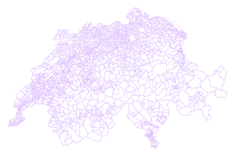
Municipal boundaries: time series since 1850
The « Municipal boundaries: time series since 1850 » product from the SFSO provides municipal geometries for all municipal states between 01.01.1850 and 31.12.2016 according to the Historisiertes Gemeindeverzeichnis (Historical List of Swiss Municipalities), for the entire territory of Switzerland and the Principality of Liechtenstein. For the period from 2016 to the present day, this time series is supplemented by the swissBOUNDARIES3D dataset published by swisstopo.
Simple
- Date (Creation)
- 2023-11-02
- Citation identifier
- ch.bfs.gemeidegrenzen_G0_zeitreihe
Citation identifier
- Purpose
-
Provide municipal boundaries between 1850 and 2016
- Status
- Planned
- Point of contact
-
Organisation name Individual name Electronic mail address Role BFS/OFS GEOSTAT
Point of contact
- Maintenance and update frequency
- As needed
- Resource format
-
Name Version ESRI Shapefile (SHP)
GeoJSON (GEOJSON)
OGC Geopackage (GPKG)
-
GEMET
-
-
sub-national boundary
-
lake
-
national boundary
-
administrative boundary
-
municipality
-
-
geocat.ch
-
-
district
-
canton
-
political boundary
-
official geodata
-
opendata.swiss
-
FSDI Federal Spatial Data Infrastructure
-
- Access constraints
- Intellectual property rights
- Use constraints
- Other restrictions
- Other constraints
- Opendata BY ASK: Open use. Must provide the source. Use for commercial purposes requires permission of the data owner.
- Aggregate Datasetindentifier
- 86cb844f-296b-40cb-b972-5b1ae8028f7c
- Association Type
- isTemporalStatOf
- Spatial representation type
- Vector
- Language
- Deutsch
- Language
- Français
- Character set
- UTF8
- Topic category
-
- Boundaries
- Environment description
-
ESRI ArcGIS
Extent
- Description
-
Switzerland
))

- Reference system identifier
- EPSG: 2056
- Distribution format
-
Name Version ESRI Shapefile (SHP)
GeoJSON (GEOJSON)
OGC Geopackage (GPKG)
- OnLine resource
-
Protocol Linkage Name MAP:Preview
https://map.geo.admin.ch/index.html?lang=de&topic=bfs&bgLayer=ch.swisstopo.swissimage&layers=ch.swisstopo.swissboundaries3d-gemeinde-flaeche.fill&layers_timestamp=1850&E=2660000&N=1190000&zoom=1&time=1850 Preview map.geo.admin.ch
CHTOPO:specialised-geoportal
https://www.bfs.admin.ch/bfs/de/home/dienstleistungen/geostat.html GEOSTAT
OPENDATA:SWISS
https://opendata.swiss/de/perma/5302e4a5-fbea-4e04-a9bd-8955bb73ab05@bundesamt-fur-statistik-bfs Permalink opendata.swiss
- OnLine resource
-
Protocol Linkage Name WWW:DOWNLOAD-URL
https://data.geo.admin.ch/browser/index.html#/collections/ch.bfs.historisierte-administrative_grenzen_g0 Geodata
CHTOPO:specialised-geoportal
https://www.bfs.admin.ch/bfs/de/home/dienstleistungen/geostat/geodaten-bundesstatistik/administrative-grenzen/gemeindegrenzen-zeitreihe.html Thematic information
WWW:LINK
https://www.bfs.admin.ch/bfs/de/home/dienstleistungen/geostat/geodaten-bundesstatistik/administrative-grenzen/gemeindegrenzen-zeitreihe.assetdetail.29967172.html Data description
ESRI:REST
https://data.geo.admin.ch/api/stac/v0.9/collections/ch.bfs.historisierte-administrative_grenzen_g0 RESTful API from geo.admin.ch
- Hierarchy level
- Dataset
Metadata
- File identifier
- 5302e4a5-fbea-4e04-a9bd-8955bb73ab05 XML
- Metadata language
- Deutsch
- Character set
- UTF8
- Hierarchy level
- Dataset
- Date stamp
- 2023-12-19T10:59:35.512Z
- Metadata standard name
-
GM03 2+
- Metadata author
-
Organisation name Individual name Electronic mail address Role BFS/OFS GEOSTAT
Point of contact
- Other language
-
Language Character encoding French UTF8 Italian UTF8 English UTF8 Romansh UTF8 German UTF8
 INSPIRE Geoportal


