 INSPIRE Geoportal
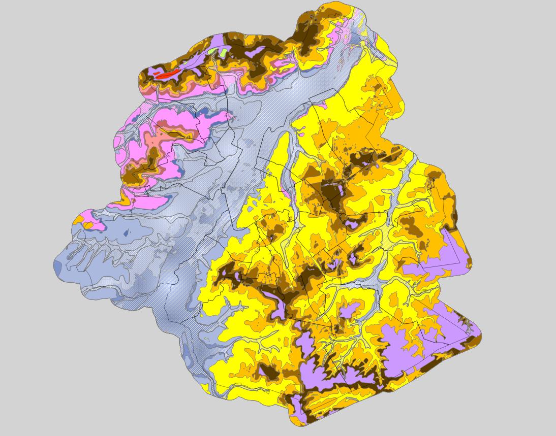
INSPIRE - Extension spatiale des unités stratigraphiques de la Région de Bruxelles-Capitale (US/RBC)
INSPIRE - Ruimtelijke uitbreiding van de stratigrafische eenheden van het Brussels Hoofdstedelijk Gewest (SE/BHG)
INSPIRE - Spatial extent of the Stratigraphic Units of the Brussels-Capital Region (SU/BCR)
Région de Bruxelles-Capitale : extensions spatiales des unités stratigraphiques (US/RBC), hors US/RBC_011 Remblais et US/RBC_12 Couverture limoneuse. Ces données sont limitées aux frontières de la Région Bruxelles-Capitale étendues d’une zone tampon de 500m. Les données attributaires indiquent à quelle unité hydrogéologique (UH/RBC) appartiennent chacune des US/RBC. Ces extensions spatiales ont été construites à partir du modèle géologique BruStrati3D v1.1, excepté les extensions des unités quaternaires qui sont issues de la base de données Databank Ondergrond Vlaanderen. Ces données étant issues de modèles, elles peuvent contenir des erreurs, des imprécisions et des lacunes. Elles ont une valeur indicative et ne peuvent en aucun cas remplacer une étude réalisée par un expert. Bruxelles Environnement ne peut être tenue responsable des conséquences résultant de l'utilisation de ces données.
Brussels Hoofdstedelijk Gewest: ruimtelijke uitbreidingen van de stratigrafische eenheden (SE/BHG) (behalve SE/BHG_11 Ophogingen en SE/BHG_12 Leemachtige deklagen). Deze gegevens zijn beperkt tot de grenzen van het Brussels Hoofdstedelijk Gewest, met een bufferzone van 500 m. De attribuutgegevens geven aan tot welke hydrogeologische eenheid (HE/BHG) elk van de SE’en/BHG behoort. Deze ruimtelijke uitbreidingen werden samengesteld op basis van het geologische model BruStrati3D v1.1, met uitzondering van de uitbreidingen van de quartaire eenheden die uit de Databank Ondergrond Vlaanderen zijn ontstaan.
De gegevens die uit modellen zijn ontstaan, kunnen fouten, onduidelijkheden en lacunes bevatten. Ze hebben informatieve waarde en mogen in geen geval de plaats innemen van een studie die wordt uitgevoerd door een expert. Leefmilieu Brussel kan niet aansprakelijk worden gesteld voor de gevolgen van het gebruik van deze gegevens.
Brussels-Capital Region : spatial extents of the stratigraphic units (SU/BCR), SU/BCR_011 Backfill and SU/BCR_12 Silts cover excepted. This data is limited to the Brussels-Capital Region’s border extended with a 500 m buffer zone. The hydrogeological unit (HU/BCR) of each SU/BRC is indicated in the attribute data. These spatial extents were extracted from the BruStrati3D v1.1 geological model, except for the extensions of the quaternary units which were extracted from the Databank Ondergrond Vlaanderen database.
This data is generated from models and may contain errors, inaccuracies and gaps. It has informative value and may under no circumstances replace a study carried out by an expert. Bruxelles Environnement cannot be held liable for the consequences of the use of this information.
Simple
-
Datum (publicatie)Date (Publication)Date (Publication)
- 2019-03-07
-
Datum (revisie)Date (Revision)Date (Révision)
- 2019-03-07
-
Datum (creatie)Date (Creation)Date (Création)
- 2019-03-07
-
IdentifierCitation identifierIdentificateur
- BE.BELB / BRU_ENVI_56f23869-49cc-4cd9-bf29-0060efb6a87a
- Point of contact
-
Organisation name Individual name Electronic mail address Role Bruxelles EnvironnementLeefmilieu BrusselBrussels Environmentgeodata@environnement.bru geodata@environnement.brussels
contactpuntPoint of contactPoint de contactBruxelles EnvironnementLeefmilieu BrusselBrussels Environmentgeodata@environnement.bru geodata@environnement.brussels
contactpuntPoint of contactPoint de contact
-
HerzieningsfrequentieMaintenance and update frequencyFréquence de mise à jour
-
indien nodigAs neededLorsque nécessaire
-
GeoBru Administrative Regions
-
-
Belgique
België
Belgium
-
Région de Bruxelles-Capitale
Brussels Hoofdstedelijk Gewest
Région de Bruxelles-Capitale
-
-
GeoBru brussels keywords
-
-
Reporting Inspire
Reporting Inspire
Reporting Inspire
-
-
(Juridische) toegangsrestrictieAccess constraintsContraintes d'accès
-
andersOther restrictionsAutres restrictions
-
Autres contraintesOverige beperkingenOther constraints
-
Pas de restriction concernant l'accès publicGeen beperkingen op openbare toegangNo limitations to public access
-
(Juridische) gebruiksbeperkingUse constraintsContraintes d'utilisation
-
andersOther restrictionsAutres restrictions
-
Ruimtelijk schemaSpatial representation typeType de représentation spatiale
-
vectorVectorVecteur
-
ToepassingsschaalDenominatorDénominateur de l'échelle
- 500
-
TaalLanguageLangue de la ressource
- Français
-
OnderwerpTopic categoryCatégorie ISO
-
-
Geo wetenschappelijke dataGeoscientific informationSciences de la terre, géosciences
-
))
- gml32:beginPosition
- 2019-03-07
- gml32:endPosition
- 2024-01-01
-
CodeCodeUnique resource identifier
-
EPSG:31370EPSG:31370EPSG:31370
- Distribution format
-
Name Version GMLGMLGML
- Units of distribution
-
B
-
Bestands grootteTransfer sizeTaille de transfert
- 1
- OnLine resource
-
Protocol Linkage Name WWW:DOWNLOAD-1.0-http--download
https://wfs.environnement.brussels/belb_inspire_surface_geology_stratigraphy?SERVICE=WFS&REQUEST=GetFeature&TYPENAME=MappedFeature&OUTPUTFORMAT=text/xml;%20subtype=gml/3.2.1&VERSION=2.0.0 MappedFeature WWW:DOWNLOAD-1.0-http--download
https://wfs.environnement.brussels/belb_inspire_surface_geology_stratigraphy?SERVICE=WFS&REQUEST=GetFeature&TYPENAME=GeologicUnit&OUTPUTFORMAT=text/xml;%20subtype=gml/3.2.1&VERSION=2.0.0 GeologicUnit WWW:DOWNLOAD-1.0-http--download
https://wfs.environnement.brussels/belb_inspire_surface_geology_stratigraphy?SERVICE=WFS&REQUEST=GetFeature&TYPENAME=GeologicEvent&OUTPUTFORMAT=text/xml;%20subtype=gml/3.2.1&VERSION=2.0.0 GeologicEvent WWW:DOWNLOAD-1.0-http--download
https://wfs.environnement.brussels/belb_inspire_surface_geology_stratigraphy?SERVICE=WFS&REQUEST=GetFeature&TYPENAME=GeologicCollection&OUTPUTFORMAT=text/xml;%20subtype=gml/3.2.1&VERSION=2.0.0 GeologicCollection
- OnLine resource
-
Protocol Linkage Name OGC:WMS
https://wms.environnement.brussels/belb_inspire_surface_geology_stratigraphy?VERSION=1.3.0&SERVICE=wms&REQUEST=GetCapabilities GeologicUnit
GeologicUnit
GeologicUnit
-
Niveau kwaliteitsbeschrijvingHierarchy levelNiveau
-
datasetDatasetJeu de données
Resultaat conformiteit met de specificatie
Conformance result
Résultat de conformité
-
Datum (publicatie)Date (Publication)Date (Publication)
- 2010-12-08
-
ExplicationUitlegExplanation
-
Le jeu de données répond aux exigences minimales prédécrites
De dataset volgt de minimale vereissen
The dataset does fullfill the minimal requirements
-
Indicatie van conformiteit met de specificatiePassDegré de conformité
- Yes
-
Généralités sur la provenance
-
Bruxelles Environnement / Leefmilieu Brussel
Metadata
-
Metadata IDFile identifierIdentifiant de la fiche
- 56f23869-49cc-4cd9-bf29-0060efb6a87a XML
-
TaalMetadata languageLangue
- Français
-
KaraktersetCharacter setJeu de caractères
-
MD_CharacterSetCode_utf8MD_CharacterSetCode_utf8MD_CharacterSetCode_utf8
-
Hierarchisch niveauHierarchy levelType de ressource
-
datasetDatasetJeu de données
-
Metadata datumDate stampDate des métadonnées
- 2023-12-14T22:19:05
- Metadata standard name
-
ISO19115
- Metadata standard version
-
2003/Cor.1:2006
- Metadata author
-
Organisation name Individual name Electronic mail address Role Bruxelles EnvironnementLeefmilieu BrusselBrussels Environmentgeodata@environnement.bru geodata@environnement.brussels
contactpuntPoint of contactPoint de contact
- Other language
-
Language Character encoding Nederlands; VlaamsDutch; FlemishNéerlandais; flamandutf8UTF8Utf8EngelsEnglishAnglaisutf8UTF8Utf8FransFrenchFrançaisutf8UTF8Utf8
Overviews

Spatial extent
Provided by
