 INSPIRE Geoportal
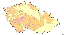
Radon risk map 1 : 50,000 (GEOCR50) – INSPIRE view service (theme Natural risk zones)
INSPIRE View Service provides the results of radon index mapping in the Czech Republic in a scale of 1 : 50,000.
Simple
Identification info
- Alternate title
-
Geohazardy_radon50
-
Alternate title
-
Radon risk map of the Czech Republic 1 : 50,000
-
Date (Publication)
- 2016-03-24
-
Date (Creation)
- 2012-02-01
- Point of contact
-
Organisation name Individual name Electronic mail address Role Czech Geological Survey
Ing. Martin Paleček Point of contactCzech Geological Survey
Custodian
-
GEMET - Concepts, version 3.1
- Keywords
-
-
EGDI
-
CzechGeo
-
-
Use constraints
-
Other restrictions
-
Other constraints
-
no conditions apply
-
Other constraints
-
Copyright (All Rigths Reserved)
-
Access constraints
-
Other restrictions
-
Other constraints
-
no limitations to public access
-
Service Type
- view
N
S
E
W
))
- Unique resource identifier
- Česká republika
-
Coupling Type
-
Tight
- Contains Operations
-
Operation Name Distributed Computing Platforms Connect Point GetCapabilities
Web serviceshttps://mapy.geology.cz/arcgis/services/Geohazardy/radon50/MapServer/WmsServer? GetMap
Web serviceshttps://mapy.geology.cz/arcgis/services/Geohazardy/radon50/MapServer/WmsServer? GetFeatureInfo
Web serviceshttps://mapy.geology.cz/arcgis/services/Geohazardy/radon50/MapServer/WmsServer? esri_wms:GetStyles
Web serviceshttps://mapy.geology.cz/arcgis/services/Geohazardy/radon50/MapServer/WmsServer?
-
Reference system identifier
- CRS: / 84
- Unique resource identifier
- EPSG:4326
- Unique resource identifier
- EPSG:5514
- Unique resource identifier
- EPSG:102067
-
Hierarchy level
-
Service
- Other
-
služba
Conformance result
-
Date (Publication)
- 2009-10-20
-
Explanation
-
See referred specification
-
Pass
- Yes
Metadata
-
File identifier
- 56f3b3f2-c258-40c8-87cb-335c0a010852 XML
-
Metadata language
- cze
-
Character set
-
UTF8
-
Hierarchy level
-
Service
- Hierarchy level name
-
služba
- Hierarchy level name
- http://geoportal.gov.cz/inspire
-
Date stamp
- 2023-12-07
- Metadata standard name
-
ISO 19115/INSPIRE_TG2/CZ4
- Metadata standard version
-
2003/cor.1/2006
- Metadata author
-
Organisation name Individual name Electronic mail address Role Czech Geological Survey
Mgr. Pavla Kramolišová Point of contact
- Other language
-
Language Character encoding EnglishUTF8
Overviews
Spatial extent
N
S
E
W
Provided by

Associated resources
Not available