 INSPIRE Geoportal
World Settlement Footprint (WSF) 3D - Vector Tiles - Global, 90m
This dataset is a derivative of the WSF3D raster dataset tailored for the web. As a tiled vector dataset, it enables dynamic client-side visualization of the WSF3D metrics
Simple
- Date (Creation)
- 2023-02-15T00:00:00
- Edition
-
2.0
- Citation identifier
- https://geoservice.dlr.de/catalogue/srv/metadata/57b9510f-a145-4b22-ac87-3389c53e6d2b
- Presentation form
- Digital map
- Purpose
-
Visualization of the WSF3D building attributes in 3D.
- Status
- Completed
- Point of contact
-
Organisation name Individual name Electronic mail address Role German Aerospace Center (DLR)
EOC Geoservice
Point of contact German Aerospace Center (DLR)
Stefan Keim
Author DLR/EOC Land Surface Dynamics
WSF Team
Point of contact
- Maintenance and update frequency
- As needed
- Keywords
-
-
opendata
-
DLR
-
EOC
-
building height
-
building density
-
building volume
-
urbanization
-
3D
-
global
-
Sentinel-1
-
Sentinel-2
-
TanDEM-X
-
vector tiles
-
inspireidentifiziert
-
-
GEMET - INSPIRE themes, version 1.0
-
-
Land cover
-
- Use limitation
-
Nutzungseinschränkungen: Das DLR ist nicht haftbar für Schäden, die sich aus der Nutzung ergeben. / Use Limitations: DLR not liable for damage resulting from use.
- Access constraints
- Other restrictions
- Other constraints
- Es gelten keine Zugriffsbeschränkungen.
- Use constraints
- Other restrictions
- Other constraints
-
Nutzungsbedingungen: Lizenz, https://creativecommons.org/licenses/by/4.0 / terms of use: https://creativecommons.org/licenses/by/4.0/
- Other constraints
-
{"id": "cc-by/4.0",
"name": "Creative Commons Namensnennung - 4.0 International (CC BY 4.0)",
"url": " http://dcat-ap.de/def/licenses/cc-by/4.0",
"quelle": "Copyright DLR (year of production)"}
- Spatial representation type
- Grid
- Denominator
- 180000
- Language
- English
- Character set
- UTF8
- Topic category
-
- Imagery base maps earth cover
))
- Begin date
- 2012-01-01T00:00:00
- End date
- 2019-12-31T23:59:00
- Unique resource identifier
- EPSG:3857
- Distribution format
-
Name Version mbTiles
- OnLine resource
-
Protocol Linkage Name WWW:LINK-1.0-http--link
https://wis.eoc.dlr.de/wsf3d WSF 3D - Viewer
WWW:LINK-1.0-http--link
https://download.geoservice.dlr.de/WSF3D/files/ EOC Download Service
WWW:LINK-1.0-http--link
https://www.dlr.de/content/de/artikel/news/2022/02/20220510_dlr-daten-zeigen-wo-menschen-durch-naturkatastrophen-bedroht-sind.html DLR News
- Hierarchy level
- Dataset
Domain consistency
- Measure identification
- INSPIRE / Conformity_001
Conformance result
- Date (Publication)
- 2010-12-08
- Explanation
-
See the referenced specification
- Pass
- Yes
- Statement
-
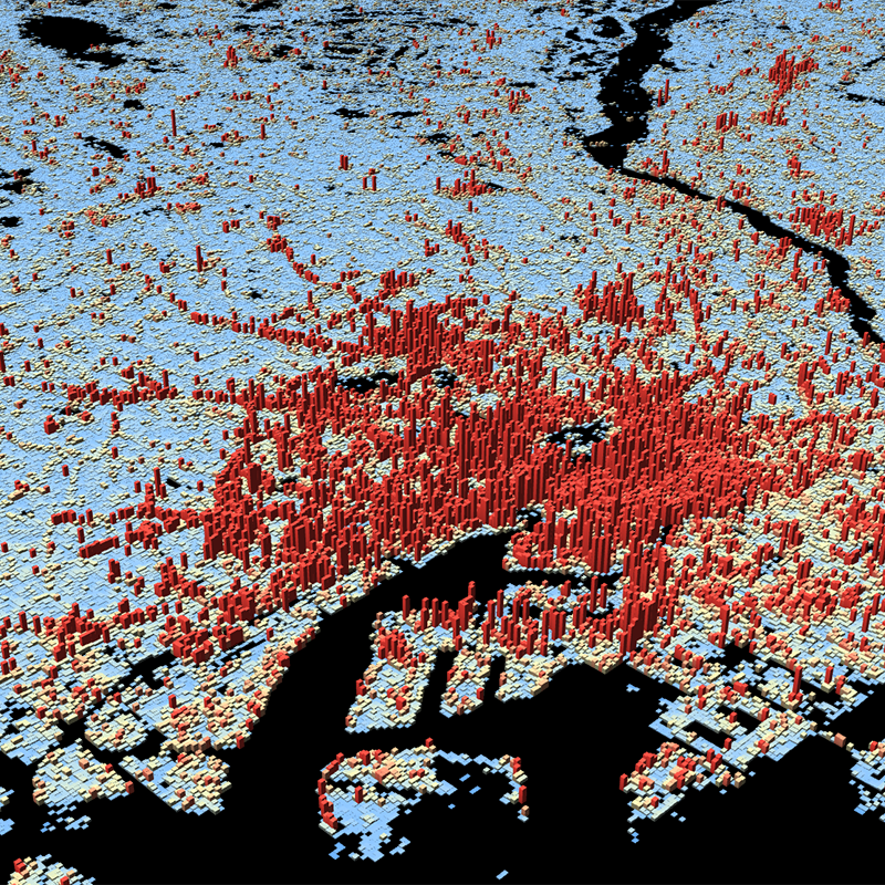
The World Settlement Footprint 3D human settlements mask derived from Sentinel-1 and Sentinel-2 satellite imagery in combination with digital elevation data and radar imagery collected by the TanDEM-X mission.
- Description
-
World Settlement Footprint 3D - Building Area Processing:
Data:
Sentinel-1 and Sentinel-2 satellite imagery at 10 m spatial resolution is used to generate the World Settlement Footprint (WSF) 2019. This layer is supplemented with information on the percent impervious (IMP) surface and serves as a human settlement mask.
The 12 m TanDEM-X Digital Elevation Model and the underlying 3 m Synthetic Aperture Radar (SAR) amplitude images give information on the vertical structuring within the built-up area.
Processing:
The pixel grid of the WSF3D raster was polygonized and the resulting features where attributed with the `Building_Height`, `Building_Area` and the polygon area. Based on the full resolution (zoom level 11), the polygons got dissolved and their attributes aggregated to limit the size of individual tiles in lower zoom levels.
Quality Assurance:
Manually checked against original raster dataset. A comprehensive validation campaign has been undertaken based on 3D building models obtained for 19 regions worldwide (~86,000 km2) and street-view samples indicating the number of floors for >130,000 individual buildings in 15 additional cities.
Metadata
- File identifier
- 57b9510f-a145-4b22-ac87-3389c53e6d2b XML
- Metadata language
- English
- Character set
- UTF8
- Hierarchy level
- Dataset
- Hierarchy level name
-
Dataset
- Date stamp
- 2023-03-02T13:42:53
- Metadata standard name
-
19115-1:2014/19139
- Metadata standard version
-
2003/Cor.1:2006
- Metadata author
-
Organisation name Individual name Electronic mail address Role German Aerospace Center(DLR)
Point of contact
Overviews
Spatial extent
Provided by
