INSPIRE Geoportal
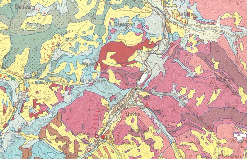
Lithologisch-petrografische Karte der Schweiz 1:200000
Carte lithologique et pétrographique de la Suisse 1:200000
Carta litologica e petrografica della Svizzera 1:200000
Lithological-petrographic map of Switzerland 1:200000
Die lithologisch-petrografische Karte der Schweiz 1:200'000 liefert eine Übersicht des Untergrundes klassiert nach lithologisch-petrografischen Kriterien. Die Legende ist insbesondere im Hinblick auf die Nutzung des Untergrundes konzipiert (z.B. Gewinnung von mineralischen Rohstoffen, Bauvorhaben). Überlagert sind Punktangaben zu Abbaustellen von Locker- und Festgesteinen sowie Standorte verarbeitender Betriebe (Stand der Erhebung: 1963–1967).
(Originalbezeichnung: Geotechnische Karte der Schweiz 1:200'000)
La carte lithologique et pétrographique de la Suisse 1:200'000 fournit une vue d'ensemble du sous-sol classé selon des critères lithologiques et pétrographiques. La légende est particulièrement conçue pour faciliter l'identification des possibilités d'utilisation du sous-sol (p.ex. exploitation de ressources minérales, projets de construction). Les points superposés localisent les sites d'exploitation et/ou de traitement de matières premières minérales (Relevé: 1963–1967).
(Nom original: Carte géotechnique de la Suisse 1:200'000)
La carta litologica e petrografica della Svizzera 1:200'000 fornisce una visione d'insieme del sottosuolo classificato secondo criteri litologici e petrografici. La legenda è concepita in particolare per facilitare l'identificazione delle possibilità d'utilizzazione del sottosuolo (p.es. sfruttamento di risorse minerali, progetti di costruzione). I punti sovrastanti indicano la posizione dei siti di estrazione e/o lavorazione di materie prime minerali (Rilevamento del: 1963–1967).
(Denominazione originale: Carta geotecnica della Svizzera 1:200'000)
The Lithological-petrographic map of Switzerland 1:200,000 provides an overview of the subsurface classified according to lithological-petrographic criteria. The legend is designed in particular to facilitate the identification of the possible usages of the subsurface (e.g. extraction of mineral resources, construction projects). The point data overlay indicates the location of extraction and/or processing sites of mineral raw materials (Survey: 1963–1967).
(Original name: Geotechnical map of Switzerland 1:200,000)
Simple
-
AlternativtitelAutres appellations ou acronymesTitolo alternativoAlternate title
-
Litho-petrografische Karte 200
Carte litho-pétrographique 200
Carta litopetrografica 200
Litho-petrographic map 200
-
Date (Création)Data (Creazione)Date (Creation)Date (Creation)Datumsangaben (Erstellung)
- 1967-01-01
-
IdentificateurIdentificatoreCitation identifierCitation identifierIdentifikator
- ch.swisstopo.geologie-geotechnik-gk200
Identificateur
Identificatore
Citation identifier
Citation identifier
Identifikator
-
Forme de la présentationFormato di presentazionePresentation formPresentation formPräsentationsform
-
Carte papierMappa cartaceaHardcopy mapHardcopy mapAnaloge Karte
-
Gemeinsamer TitelTitre collectifTitolo collettivo
-
Geotechnisches Kartenwerk
Cartes géotechniques
Carte geotecniche
-
ZweckBut
-
Darstellung des geologischen Untergrunds nach lithologisch-petrografischen Kriterien; Übersicht über Vorkommen, Abbau und Verarbeitung mineralischer Rohstoffe der Schweiz.
Représentation du sous-sol géologique selon des critères lithologiques-pétrographiques; Vue d'ensemble des gisements, exploitations et traitements de ressources minérales de la Suisse.
- Point of contact
-
Organisation name Individual name Electronic mail address Role Fachgruppe Georessourcen Schweiz
Groupe géoressources suisses
Gruppo georisorse svizzere
Georesources Switzerland Group
FournisseurFornitore della risorsaResource providerResource providerAnbieterBundesamt für Landestopografie swisstopo
Office fédéral de topographie swisstopo
Ufficio federale di topografia swisstopo
Federal Office of Topography swisstopo
Uffizi federal da topografia swisstopo
Point de contactPunto di contattoPoint of contactPoint of contactAnsprechpartnerBundesamt für Landestopografie swisstopo
Office fédéral de topographie swisstopo
Ufficio federale di topografia swisstopo
Federal Office of Topography swisstopo
Uffizi federal da topografia swisstopo
PropriétaireProprietarioOwnerOwnerEigentümer / Datenherr
-
Fréquence de mise à jourFrequenza di aggiornamentoMaintenance and update frequencyMaintenance and update frequencyÜberarbeitungsintervall
-
Non planifiéeNon pianificatoNot plannedNot plannedNicht geplant
-
geocat.ch
-
-
Aufbewahrungs- und Archivierungsplanung AAP - Bund
Planification de la conservation et de l'archivage AAP - Conféderation
Pianificazione della conservazione e dell’archiviazione AAP - Confederazione
Conservation and archiving planning AAP - Confederation
-
Geobasisdaten
géodonnées de base
geodati di base
official geodata
-
Petrografie
pétrographie
petrografia
petrography
-
Lithologie
lithologie
litologia
lithology
-
opendata.swiss
opendata.swiss
opendata.swiss
opendata.swiss
opendata.swiss
-
-
GEMET
-
-
Abgrabung (Ort)
terrain de déblayement
scavo
excavation site
-
Geotechnik
géotechnique
geotecnica
geotechnics
-
Steinbruch
carrière
cava
quarry
-
-
GEMET - INSPIRE themes, version 1.0
-
-
Geologie
Géologie
Geologia
Geology
-
Mineralische Bodenschätze
Ressources minérales
Risorse minerarie
Mineral resources
-
-
geocat.ch
-
-
BGDI Bundesgeodaten-Infrastruktur
IFDG l’Infrastructure Fédérale de données géographiques
IFDG Infrastruttura federale dei dati geografici
FSDI Federal Spatial Data Infrastructure
-
-
Type de représentation spatialeTipo di rappresentazione spazialeSpatial representation typeSpatial representation typeRäumliche Darstellungsart
-
paperMappaperMappaperMappaperMappaperMap
-
Dénominateur de l'échelleDenominatoreDenominatorDenominatorMaßstabszahl
- 200000
-
Langue de la ressourceLingua dei datiLanguageLanguageSprache
- Deutsch
-
Encodage des caractèresSet dei caratteri dei datiCharacter setCharacter setZeichensatz
-
Utf8UTF8UTF8UTF8Utf8
-
Catégorie ISOTemaTopic categoryTopic categoryISO-Thematik
-
-
Sciences de la terre, géosciencesInformazioni geoscientificheGeoscientific informationGeoscientific informationGeowissenschaften
-
Étendue
Estensione
Extent
Extent
Ausdehnung
-
BeschreibungDescriptionDescrizioneDescriptionDescription
-
Schweiz
Suisse
Svizzera
Switzerland
Svizra
))

-
Nom du système de référenceIdentificatore del sistema di riferimentoReference system identifierReference system identifierIdentifikator des Referenzsystems
-
Referenzsystem entsprechend der zugrundeliegenden topographischen Karte (CH1903)Système de référence conformément à la carte topographique sous-jacente (CH1903)
- Distribution format
-
Name Version GeoTIFF (GEOTIFF)
- OnLine resource
-
Protocol Linkage Name MAP:Preview
https://map.geo.admin.ch/?layers=ch.swisstopo.geologie-geotechnik-gk200 Vorschau map.geo.admin.ch
Aperçu map.geo.admin.ch
Previsione map.geo.admin.ch
Preview map.geo.admin.ch
OGC:WMS
https://wms.geo.admin.ch/?SERVICE=WMS&VERSION=1.3.0&REQUEST=GetCapabilities&lang=de ch.swisstopo.geologie-geotechnik-gk200
ch.swisstopo.geologie-geotechnik-gk200
ch.swisstopo.geologie-geotechnik-gk200
ch.swisstopo.geologie-geotechnik-gk200
ch.swisstopo.geologie-geotechnik-gk200
OGC:WMTS
https://wmts.geo.admin.ch/EPSG/3857/1.0.0/WMTSCapabilities.xml?lang=de ch.swisstopo.geologie-geotechnik-gk200
ch.swisstopo.geologie-geotechnik-gk200
ch.swisstopo.geologie-geotechnik-gk200
ch.swisstopo.geologie-geotechnik-gk200
ch.swisstopo.geologie-geotechnik-gk200
- OnLine resource
-
Protocol Linkage Name WWW:LINK
https://georessourcen.ethz.ch Fachgruppe Georessourcen Schweiz
Groupe géoressources suisses
Gruppo georisorse svizzere
Georesources Switzerland Group
WWW:DOWNLOAD-URL
https://data.geo.admin.ch/ch.swisstopo.geologie-geotechnik-gk200 Download (data.geo.admin.ch)
Téléchargement (data.geo.admin.ch)
Download (data.geo.admin.ch)
Download (data.geo.admin.ch)
- OnLine resource
-
Protocol Linkage Name CHTOPO:specialised-geoportal
https://map.georessourcen.ethz.ch/ Rohstoffinformationssystem
Système d'informations des matières premières
Sistema d'informazione sulle materie prime
Resources Information System
WWW:LINK
https://www.geologieportal.ch/de/themen/grundlagen-der-geologie/geotechnik-ingenieurgeologie.html Geologie-Portal: Geotechnik & Ingenieurgeologie
Portail géologique: Géotechnique & géologie de l’ingénieur
Portale Geologico: Geotecnica e ingegneria geologica
Geology Portal: Geotechnics & engineering geology
ESRI:REST
https://api3.geo.admin.ch/rest/services/api/MapServer/ch.swisstopo.geologie-geotechnik-gk200 RESTful API von geo.admin.ch
RESTful API de geo.admin.ch
RESTful API da geo.admin.ch
RESTful API from geo.admin.ch
RESTful API dad geo.admin.ch
OPENDATA:SWISS
https://opendata.swiss/de/perma/6dd16d72-047b-4489-91dc-b36eeabf972e@bundesamt-fur-landestopografie-swisstopo Permalink opendata.swiss
Permalink opendata.swiss
Permalink opendata.swiss
Permalink opendata.swiss
-
NiveauLivelloHierarchy levelHierarchy levelBezugsebene
-
Collection de donnéesSerieSeriesSeriesSerie
-
ErläuterungGénéralités sur la provenance
-
Der geologische Untergund wurde auf der Basis des Geologischen Atlas 25'000 kompiliert. In Gebieten, in denen dieser bei Erstellung nicht vorhanden war, wurde auf geologische Spezialkarten und weitere publizierte Unterlagen zurückgegriffen. Die Daten wurden durch zum Teil unpublizierte Studien ergänzt. Die Auflösung am Boden kann bei abgeleitetet Themenkarten nicht exakt bestimmt werden, da die Lage der geologischen Objekte der Interpretation des kartierenden Geologen unterliegt. Sie weichen zusätzlich durch Gewichtung und Generalisierung vom eigentlichen Ort ab.
Le sous-sol géologique a été compilé sur la base de l'Atlas géologique au 1:25000. Pour les zones auxquelles l'atlas n'était pas disponible lors de la réalisation, les carte géologiques spéciales et d'autres publications ont été consultées. Les données ont été complétées par des études non publiées. La résolution au sol ne peut être définie de manière exacte, la position des objets géologiques dépend de l'interprétation du géologue-cartographe. D'autres imprécisions sont dues à la pondération et à la généralisation de la carte de base.
Metadata
-
Identifiant de la ficheIdentificatore del file di metadatiFile identifierFile identifierMetadatensatzidentifikator
- 6dd16d72-047b-4489-91dc-b36eeabf972e XML
-
LangueLingua dei metadatiMetadata languageMetadata languageSprache
- Deutsch
-
Jeu de caractèresSet dei caratteri dei metadatiCharacter setCharacter setZeichensatz
-
Utf8UTF8UTF8UTF8Utf8
-
Type de ressourceLivello gerarchicoHierarchy levelHierarchy levelHierarchieebene
-
Jeu de donnéesDatasetDatasetDatasetDatenbestand
-
Type de ressourceLivello gerarchicoHierarchy levelHierarchy levelHierarchieebene
-
Collection de donnéesSerieSeriesSeriesSerie
-
Date des métadonnéesData dei metadatiDate stampDate stampDatum
- 2023-06-16T13:36:56.728Z
- Metadata standard name
-
GM03 2+
- Metadata author
-
Organisation name Individual name Electronic mail address Role Fachgruppe Georessourcen Schweiz
Groupe géoressources suisses
Gruppo georisorse svizzere
Georesources Switzerland Group
Point de contactPunto di contattoPoint of contactPoint of contactAnsprechpartner
- Dataset URI
-
http://www.sgtk.ch/main.asp?content=inhalt/produkte/baugrund_geotechnische_karten.htm&nav=23
- Other language
-
Language Character encoding FrançaisFranceseFrenchFrenchFranzösischUtf8UTF8UTF8UTF8Utf8ItalienItalianoItalianItalianItalienischUtf8UTF8UTF8UTF8Utf8AnglaisIngleseEnglishEnglishEnglischUtf8UTF8UTF8UTF8Utf8RomancheRomancioRomanshRomanshRätoromanischUtf8UTF8UTF8UTF8Utf8AllemandTedescoGermanGermanDeutschUtf8UTF8UTF8UTF8Utf8