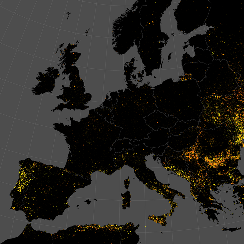
Burnt Area Daily NRT Incremental Product - MODIS - Europe
The product is automatically derived from Aqua/Terra (MODIS) satellite imagery in near-real time. It is an incremental product, meaning that the retrieved results are updated as soon as new input data becomes available over a timespan of ten days. Besides the fire perimeter and detection time, each feature contains information about the severity of the burning.
Simple
- Date (Creation)
- 2022-04-01T00:00:00
- Citation identifier
- https://geoservice.dlr.de/catalogue/srv/metadata/6e614923-3c94-4828-bb92-49d3da4ae0c5
- Presentation form
- Digital map
- Purpose
-
This dataset contains the quality enhanced burnt areas (detected using MODIS imagery) for Europe, combined for single days.
- Status
- ongoing
- Point of contact
-
Organisation name Individual name Electronic mail address Role German Aerospace Center (DLR)
Michael Nolde
Author German Aerospace Center (DLR)
Florian Fichtner
Author German Aerospace Center (DLR)
Torsten Riedlinger
Author German Aerospace Center (DLR)
Distributor
- Maintenance and update frequency
- Daily
- Keywords
-
-
opendata
-
Burnt Area
-
MODIS
-
Europe
-
Near-Realtime
-
Burn Severity
-
time-series
-
daily
-
inspireidentifiziert
-
-
GEMET - INSPIRE themes, version 1.0
-
-
Natural risk zones
-
- Use limitation
-
Nutzungseinschränkungen: Das DLR ist nicht haftbar für Schäden, die sich aus der Nutzung ergeben. / Use Limitations: DLR not liable for damage resulting from use.
- Access constraints
- Other restrictions
- Other constraints
- no limitations to public access
- Use constraints
- Other restrictions
- Other constraints
-
terms of use: https://creativecommons.org/licenses/by-nc/4.0/
- Other constraints
-
{"id": "cc-by-nc/4.0",
"name": "Creative Commons Namensnennung – 4.0 NonCommercial 4.0 International (CC BY-NC 4.0)",
"url": " https://creativecommons.org/licenses/by-nc/4.0/",
"quelle": "Copyright DLR (year)"}
- Spatial representation type
- Vector
- Denominator
- 600000
- Language
- English
- Character set
- UTF8
- Topic category
-
- Environment
))
- Begin date
- 2022-08-03
- Unique resource identifier
- EPSG:3035
- Topology level
- Geometry only
- Geometric object type
- Surface
- Distribution format
-
Name Version GeoPackage
- OnLine resource
-
Protocol Linkage Name OGC:WMS
https://geoservice.dlr.de/eoc/land/wms? BURNTAREA_MODIS_P1D
OGC:WMS-http-get-capabilities
https://geoservice.dlr.de/eoc/demo/wms?SERVICE=WMS%26REQUEST=GetCapabilities WWW:LINK-1.0-http--link
https://geoservice.dlr.de/web/maps/eoc:burntarea:modis:daily EOC Geoservice map context
WWW:LINK-1.0-http--link
https://services.zki.dlr.de/fire ZKI Fire Monitoring System
WWW:LINK-1.0-http--link
https://github.com/dlr-eoc/ukis-data-tutorials UKIS Data Tutorials - Burnt Area Products
WWW:LINK-1.0-http--link
https://www.dlr.de/eoc/en/desktopdefault.aspx/tabid-18220/29005_read-77114 Burnt Areas - EOC News
- Hierarchy level
- Series
Domain consistency
- Measure identification
- INSPIRE / Conformity_001
Conformance result
- Date (Publication)
- 2010-12-08
- Explanation
-
See the referenced specification
- Pass
- Yes
- Statement
-
The product is based on mid resolution, optical data from the Aqua/Terra MODIS sensor level 1 NRT product. It utilizes information from the red and near-infrared domain, in combination with thermal anomaly data from the MODIS and VIIRS sensors
- Description
-
Burnt Area Daily NRT Processing:
Processing:
The burnt area segmentation method is based on the morphological snakes algorithm in combination with a region growing approach. A differential NDVI mosaic is used as the basis for the segmentation.
The methodology is described here: https://www.mdpi.com/2072-4292/12/13/2162/html.
An application of the methodology is found here: https://www.mdpi.com/2072-4292/13/24/4975/html
Quality Assurance:
The product has been thoroughly tested against reference datasets provided by NASA, ESA and the Joint Research Center of the European Union
(JRC). The results of the inter-comparison can be found in the following publication:
Michael Nolde, Simon Plank, Torsten Riedlinger. (2020, July 6). An Adaptive and Extensible System for Satellite-Based, Large Scale Burnt Area
Monitoring in Near-Real Time. Remote Sens. 2020, 12, 2162. https://doi.org/10.3390/rs12132162
Metadata
- File identifier
- 6e614923-3c94-4828-bb92-49d3da4ae0c5 XML
- Metadata language
- English
- Character set
- UTF8
- Hierarchy level
- Series
- Hierarchy level name
-
Dataseries
- Date stamp
- 2023-01-18T13:52:15.163Z
- Metadata standard name
-
ISO 19115-1:2014/19139
- Metadata standard version
-
2003/Cor.1:2006
- Metadata author
-
Organisation name Individual name Electronic mail address Role German Aerospace Center (DLR)
Point of contact
Overviews


Spatial extent
))
Provided by

 INSPIRE Geoportal