 INSPIRE Geoportal
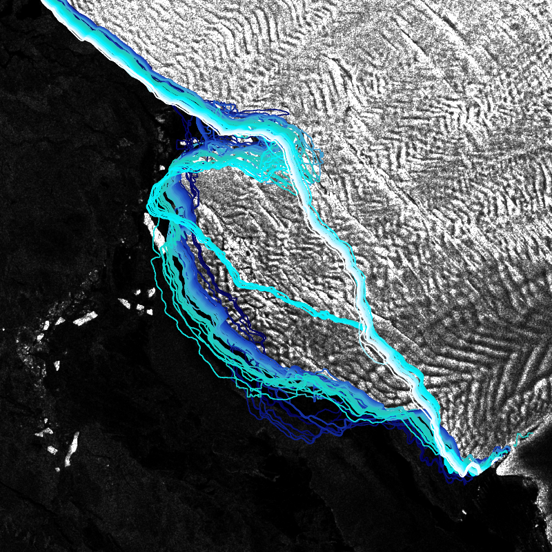
IceLines - Sentinel-1 - Antarctica
IceLines (Ice Shelf and Glacier Front Time Series) is an automated calving front monitoring service providing monthly ice shelf front time series of major Antarctic ice shelves. The provided time series allows to discover the dynamics of ice shelf front changes and calving events. The front positions are automatically derived from Sentinel-1 data based on a deep neuronal network called HED-U-Net. The time series covers the timespan 2014 to today (partly limited due to Sentinel-1 data availability). Incorrectly extracted fronts are truncated which might lead to gaps in the time series especially between December to March due to strong surface melt. Annual averages are calculated based on the extracted monthly fronts (excluding the summer months) and provide more robust results due to temporal aggregation
Simple
- Date (Creation)
- 2022-06-01T00:00:00
- Citation identifier
- https://geoservice.dlr.de/catalogue/srv/metadata/7ffa8888-fe28-4f12-b3a1-d08eae6f265e
- Presentation form
- Digital map
- Purpose
-
The main objective of IceLines is to provide dense time series of calving front change to improve our knowledge on Antarctic glacier and ice shelf front dynamics.
- Status
- ongoing
- Point of contact
-
Organisation name Individual name Electronic mail address Role German Aerospace Center (DLR)
Celia Baumhoer
Author
- Maintenance and update frequency
- As needed
- Keywords
-
-
opendata
-
IceLines
-
Antarctica
-
Landcover
-
Sentinel-1
-
time-series
-
yearly
-
monthly
-
quarterly
-
daily
-
inspireidentifiziert
-
-
GEMET - INSPIRE themes, version 1.0
-
-
Land cover
-
- Place
- Use limitation
-
Nutzungseinschränkungen: Das DLR ist nicht haftbar für Schäden, die sich aus der Nutzung ergeben. / Use Limitations: DLR not liable for damage resulting from use.
- Access constraints
- Other restrictions
- Use constraints
- Other restrictions
- Other constraints
-
Nutzungsbedingungen: Lizenz, https://creativecommons.org/licenses/by/4.0 / terms of use: https://creativecommons.org/licenses/by/4.0/
- Other constraints
-
{"id": "cc-by/4.0",
"name": "Creative Commons Namensnennung – 4.0 International (CC BY 4.0)",
"url": " http://dcat-ap.de/def/licenses/cc-by/4.0",
"quelle": "Copyright DLR (year of production)"}
- Spatial representation type
- Vector
- Denominator
- 80000
- Language
- English
- Character set
- UTF8
- Topic category
-
- Environment
))
- Begin date
- 2014-12-01
- Unique resource identifier
- EPSG:3031
- Topology level
- Topology 1D
- Geometric object type
- Curve
- Distribution format
-
Name Version GeoPackage
- OnLine resource
-
Protocol Linkage Name OGC:WMS
https://geoservice.dlr.de/eoc/land/wms? ICELINES_S1_P1Y
OGC:WMS
https://geoservice.dlr.de/eoc/land/wms? ICELINES_S1_P1M
OGC:WMS
https://geoservice.dlr.de/eoc/land/wms? ICELINES_SHELFNAMES
OGC:WMS
https://geoservice.dlr.de/eoc/land/wms? TDM_POLARDEM_ANT_COASTLINE
OGC:WMS
https://geoservice.dlr.de/eoc/land/wms? TDM_POLARDEM90_ANT_HSC
OGC:WMS-http-get-capabilities
https://geoservice.dlr.de/eoc/land/wms?SERVICE=WMS%26REQUEST=GetCapabilities WWW:LINK-1.0-http--link
https://geoservice.dlr.de/web/maps/eoc:icelines EOC Geoservice map context
WWW:LINK-1.0-http--link
https://download.geoservice.dlr.de/icelines/files/ EOC Download Service
WWW:LINK-1.0-http--link
https://www.dlr.de/eoc/en/desktopdefault.aspx/tabid-18220/29005_read-80071 IceLines - EOC News
WWW:LINK-1.0-http--link
https://play.quickchannel.com/play/kjjjzyu Video: IceLines – Monitoring von Schelfeisdynamiken in der Antarktis
- Hierarchy level
- Series
Domain consistency
- Measure identification
- INSPIRE / Conformity_001
Conformance result
- Date (Publication)
- 2010-12-08
- Explanation
-
See the referenced specification
- Pass
- Yes
- Statement
-
Created from Sentinel-1 Copernicus data provided by the Alaska Satellite Facility (ASF) https://vertex.daac.asf.alaska.edu/ and the European Space Agency (ESA) https://scihub.copernicus.eu/.
Processing steps include the pre-processing of Sentinel-1 dual and single polarized GRD scenes with the ESA SNAP toolbox. The fronts are extracted with a deep learning approach described in:
Heidler, K., Mou, L., Baumhoer, C., Dietz, A., and Zhu, X. X.: HED-UNet: Combined Segmentation and Edge Detection for Monitoring the Antarctic Coastline, IEEE Trans. Geosci. Remote Sensing, 1–14, https://doi.org/10.1109/TGRS.2021.3064606, 2021.
Baumhoer, C. A., Dietz, A. J., Kneisel, C., and Kuenzer, C.: Automated Extraction of Antarctic Glacier and Ice Shelf Fronts from Sentinel-1 Imagery Using Deep Learning, Remote Sensing, 11, 2529, https://doi.org/10.3390/rs11212529, 2019.
- Description
-
IceLines Processing:
Processing:
Calving front locations are derived from single- and dual-polarized Sentinel-1 EW data which were pre-processed with the ESA SNAP Toolbox 8.0. Front extraction is performed with the deep learning architecture “HED-UNet” and several post-processing steps including elevation thresholding, morphological filtering and vectorization. On average, the true mean distance error for fronts extracted from dual-pol imagery is 210±11 m (5.2 pixel) with 95% confidence and 354±17 m (8.8 pixel) for single-polarized imagery depending on ice shelf front morphology, occurrence of surface melt and calving pattern.
Quality Assurance:
The daily product of IceLines has been validated against 94 manually delineated fronts. For each ice shelf, two manually delineated front positions were created for random dates outside the training data period. On average, the true mean distance error for fronts extracted from dual-pol imagery is 210±11 m (5.2 pixel) with 95% confidence and 354±17 m (8.8 pixel) for single-polarized imagery. Frontal movement along centerlines can be accessed with an accuracy of 85±75 m (2.1 pixel) with 95% confidence.
Metadata
- File identifier
- 7ffa8888-fe28-4f12-b3a1-d08eae6f265e XML
- Metadata language
- English
- Character set
- UTF8
- Hierarchy level
- Series
- Hierarchy level name
-
Dataseries
- Date stamp
- 2023-10-04T14:29:06
- Metadata standard name
-
ISO 19115-1:2014/19139
- Metadata author
-
Organisation name Individual name Electronic mail address Role German Aerospace Center (DLR)
Point of contact
Overviews
Spatial extent
Provided by
