 INSPIRE Geoportal
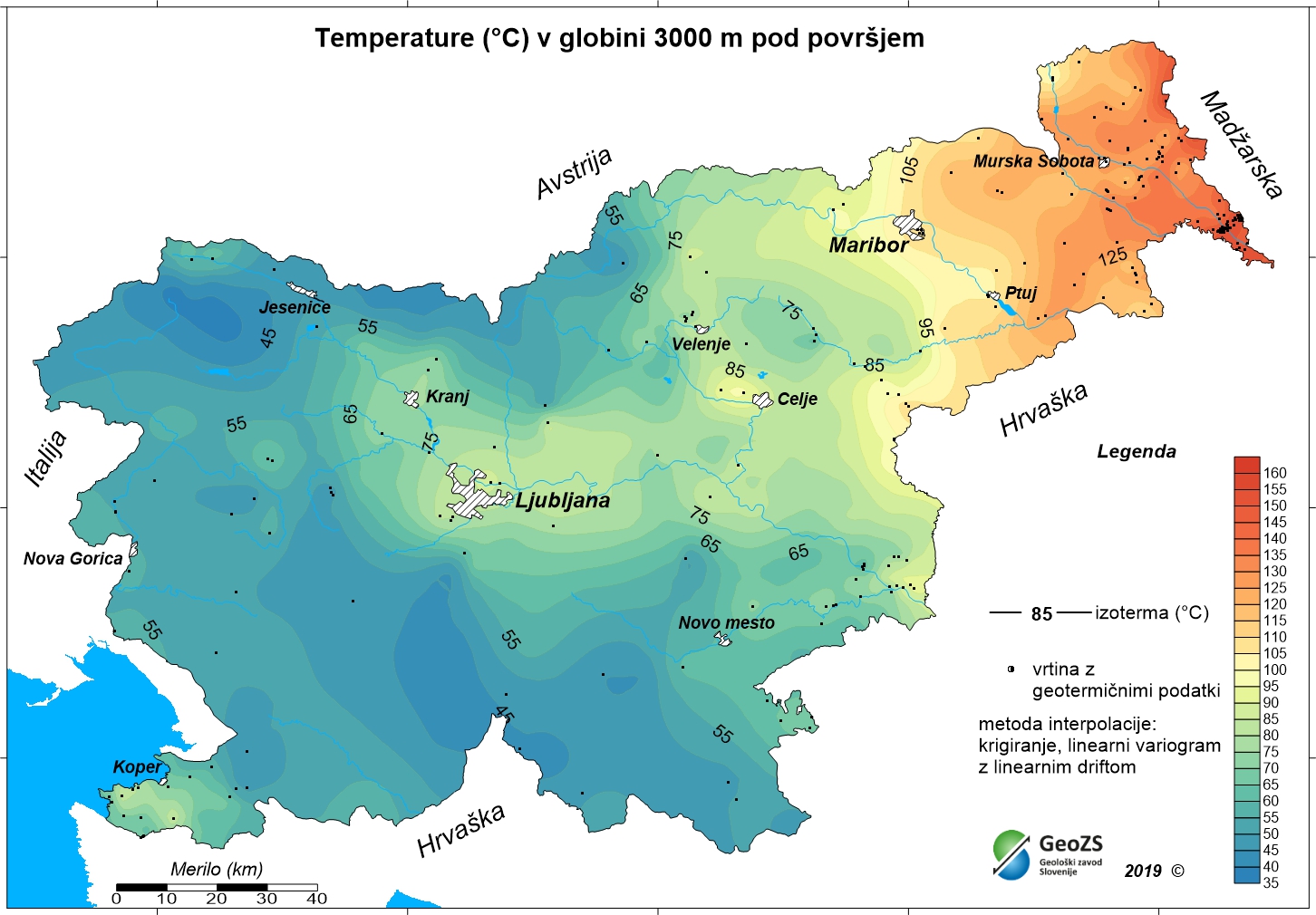
Geothermal map - Expected temperatures at a depth of 2000 m
The underground geothermal conditions can be presented, irrespective of the aquifers' position, with the appropriate geothermal maps. This map represents the expected temperatures at a depth of 2000 m and is made with data from 240 boreholes. It is made on the basis of measured temperatures in accessible boreholes throughout the country. However, since the temperature field depends on the geological structure in the depths and tectonic characteristics, the course of the isotherms is a result of many influences, such as thermal conductivity of rocks, permeability and fracturing of rocks, all of which are reflected in the measured temperatures in boreholes. In this depth also a radiogenic heat production in the rocks has smaller influence. The distribution of boreholes, which were useful for the measurement of temperature, is very uneven and different as regard the depths. Following the expected temperatures at a depth of 2000 m a stronger positive anomaly is in the northeastern part of Slovenia, from the line Maribor-Rogatec to the east, while in the eastern part of the Krka basin the anomaly is not so much visible any more. In the northeastern part of the country the anomaly is the result of the thinning of the Earth's crust and greater conductive heat flow from the Earth's mantle.
Simple
-
Date (Creation)
- 2012-12-31
-
Citation identifier
- SI.GEOZS.GEOTERM.IZO.2000m / 7a113c9b-5436-4bba-b6de-fceb7ae56bf5
-
Presentation form
-
Digital map
-
Purpose
-
The purpose of the maps is to improve insight in the geothermal conditions in the depths. With the latest geothermal maps better insight into the geothermal field of Slovenia has been obtained, especially at greater depths. The research results are potentially useful in planning future more detailed studies for the exploitation of geothermal energy. Ultimately, this means determining the micro locations for drilling deep exploration boreholes and exploitation boreholes or wells.
- Point of contact
-
Organisation name Individual name Electronic mail address Role Geological Survey of Slovenia
info@geo-zs.si
OwnerMinistry of Infrastructure
OriginatorGeological Survey of Slovenia
mag. Andrej Lapanje
andrej.lapanje@geo-zs.si
Point of contactGeological Survey of Slovenia
mag. Dušan Rajver
dusan.rajver@geo-zs.si
Point of contactGeološki zavod Slovenije
info@geo-zs.si
Custodian
-
Maintenance and update frequency
-
As needed
-
Place
-
-
Slovenia
-
-
Theme
-
-
geothermal energy
-
geothermy
-
temperature map
-
temperature at 2000 m depth
-
renewable energy resources
-
energy balance
-
hydrogeology
-
-
GEMET - INSPIRE themes, version 1.0 INSPIRE themes
-
-
Energy resources
-
-
Spatial scope
-
-
National
-
-
Theme
-
-
INSPIRE
-
-
Use limitation
-
Data is available under a Creative Commons - Attribution 4.0 International (CC BY 4.0) license. ( https://creativecommons.org/licenses/by/4.0)
-
Use limitation
-
Data is available under a Creative Commons - Attribution 4.0 International (CC BY 4.0) license. ( https://creativecommons.org/licenses/by/4.0)
-
Access constraints
-
Copyright
-
Use constraints
-
Copyright
-
Spatial representation type
-
Grid
-
Distance
- 1000 m
-
Language
- slv
-
Character set
-
UTF8
-
Topic category
-
-
Geoscientific information
-
- Environment description
-
Microsoft Windows 7 Version 6.1 (Build 7601) Service Pack 1; Esri ArcGIS 9.3.1
-
Description
-
Slovenia
))
-
Reference system identifier
- EPSG / MGI 1901 / Slovene National Grid (EPSG:3912) / 7.4
- Distribution format
-
Name Version Raster Dataset
ArcINFO Grid
- Distributor contact
-
Organisation name Individual name Electronic mail address Role Geological Survey of Slovenia
dusan.rajver@geo-zs.si
Custodian
- OnLine resource
-
Protocol Linkage Name OGC:WMS-1.1.1-http-get-map
https://mapserver.geo-zs.si/cgi-bin/Geoterm? ER.t2000_1km
WWW:DOWNLOAD-1.0-http--download
https://egeologija.si/geonetwork/srv/slv/resources.get?uuid=80f49f4d-5611-4759-b63f-45ee88008665&fname=t_2000_1km.rar&access=public t_2000_1km.rar
-
Hierarchy level
-
Dataset
-
Statement
-
Authors:
mag. Dušan Rajver, univ.dipl.ing.geol., dr. Mitja Janža, univ.dipl.ing.geol., mag. Andrej Lapanje, univ.dipl.ing.geol.
- Description
-
RAZISKAVE NACIONALNEGA POMENA; Naloga: 3.3 GEOTERMALNI VIRI, december 2012
vir zajema: dokumentacija Geološkega zavoda Slovenije
Metadata
-
File identifier
- 80f49f4d-5611-4759-b63f-45ee88008665 XML
- Metadata language
-
slv
-
Hierarchy level
-
Dataset
- Hierarchy level name
-
dataset
-
Date stamp
- 2022-01-26T18:06:11
- Metadata standard name
-
INSPIRE Metadata Implementing Rules: Technical Guidelines based on EN ISO 19115 and EN ISO 19119
- Metadata standard version
-
V. 1.2
- Metadata author
-
Organisation name Individual name Electronic mail address Role Geological Survey of Slovenia
Rada Peternel Rikanovič
rada.rikanovic@geo-zs.si
Point of contact
- Other language
-
Language Character encoding English
Overviews
Spatial extent
Provided by
