 INSPIRE Geoportal
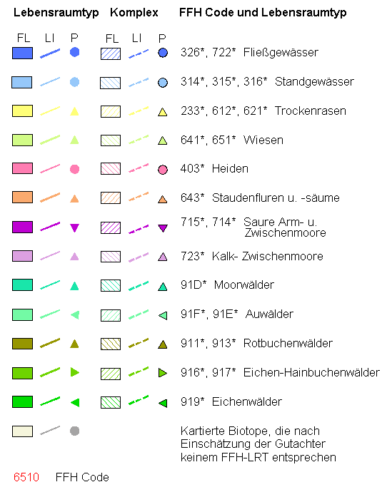
Biotoptypen: Lebensraumtypen FFH (Fauna-Flora-Habitat-Richtlinie)(Umweltatlas)
Darstellung der FFH-Lebensraumtypen (LRT) und LRT-Komplexe (Biotop hat nicht die erforderliche Ausprägung jedoch das Entwicklungspotential zu einem LRT) gemäß Fauna-Flora-Habitat-Richtlinie der EU Flächendeckende Biotopkartierung Berlin
Simple
Identification info
- Date (Publication)
- 2014-08-25
- Date (Revision)
- 2014-08-29
- Citation identifier
- https://registry.gdi-de.org/id/de.be.csw/285ac525-96d1-348e-b346-0571b47154f9
- Presentation form
- Digital map
- Point of contact
-
Organisation name Individual name Electronic mail address Role Senatsverwaltung für Mobilität, Verkehr, Klimaschutz und Umwelt Berlin
Hr. Brandt
holger.brandt@senumvk.ber holger.brandt@senumvk.berlin.de
Point of contact Senatsverwaltung für Mobilität, Verkehr, Klimaschutz und Umwelt Berlin
Hr. Brandt
holger.brandt@senumvk.ber holger.brandt@senumvk.berlin.de
Point of contact
- Theme
-
-
inspireidentifiziert
-
Karten
-
Geodaten
-
Berlin
-
Umweltatlas
-
Biotope
-
Biotopkartierung
-
Biotoptypenkartierung
-
Biotoptypenliste
-
Sekundärdaten
-
Biotopwert
-
Biotopschutz
-
FFH
-
Lebensraumtypen
-
LRT
-
Naturhaushalt
-
Landschaft
-
Forsten
-
Stadtgrün
-
wertvolle Biotope
-
Naturschutz
-
wertvolle Lebensräume
-
Fauna-Flora-Habitat-Richtlinie
-
- Keywords
-
-
infoMapAccessService
-
- Access constraints
- Other restrictions
- Other constraints
- Es gelten keine Zugriffsbeschränkungen
- Use constraints
- Other restrictions
- Other constraints
-
Für die Nutzung der Daten ist die Datenlizenz Deutschland - Namensnennung - Version 2.0 anzuwenden. Die Lizenz ist über https://www.govdata.de/dl-de/by-2-0 abrufbar. Der Quellenvermerk gemäß (2) der Lizenz lautet "Geoportal Berlin / [Titel des Datensatzes]".
- Other constraints
-
{ "id": "dl-by-de/2.0" , "name": " Datenlizenz Deutschland - Namensnennung - Version 2.0 ", "url": " https://www.govdata.de/dl-de/by-2-0", "quelle": "Geoportal Berlin / [Titel des Datensatzes]" }
- Service Type
- view
- Service Version
-
OGC:WMS 1.0.0
- Service Version
-
OGC:WMS 1.1.0
- Service Version
-
OGC:WMS 1.1.1
- Service Version
-
OGC:WMS 1.3.0
))
- Extent type code
- Yes
- Geographic identifier
- 110000000000
- Coupling Type
- Tight
- Contains Operations
-
Operation Name Distributed Computing Platforms Connect Point GetCapabilities
Web services https://fbinter.stadt-berlin.de/fb/wms/senstadt/k_fb_ffh
- Reference system identifier
- http://www.opengis.net/def/crs/EPSG/0/25833
- Distribution format
-
Name Version Text/HTML
4.01
- Hierarchy level
- Service
- Other
-
Dienst
Conformance result
- Date (Publication)
- 2009-10-20
- Explanation
-
see referenced specification
- Pass
- Yes
Metadata
- File identifier
- 81a23432-6316-3345-af6b-4334b420f6c2 XML
- Metadata language
- Deutsch
- Character set
- UTF8
- Hierarchy level
- Service
- Hierarchy level name
-
Biotoptypen: Lebensraumtypen FFH (Fauna-Flora-Habitat-Richtlinie)(Umweltatlas) Dienst
- Date stamp
- 2023-08-16T11:18:18
- Metadata standard name
-
ISO 19115/19119 – BE
- Metadata standard version
-
1.0.0
- Metadata author
-
Organisation name Individual name Electronic mail address Role Senatsverwaltung für Stadtentwicklung, Bauen und Wohnen Berlin
fisbroker@senstadt.ber fisbroker@senstadt.berlin.de
Point of contact
Overviews

Spatial extent
Provided by
