INSPIRE Geoportal
swissBOUNDARIES3D
swissBOUNDARIES3D
swissBOUNDARIES3D
swissBOUNDARIES3D
swissBOUNDARIES3D
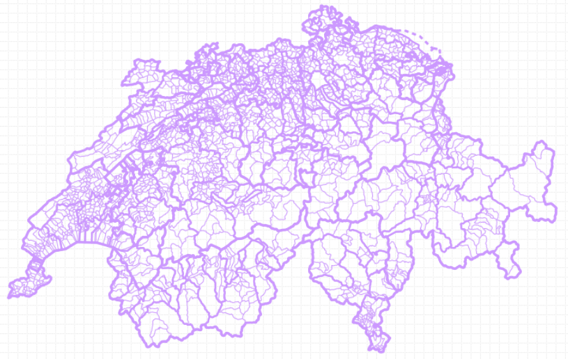
swissBOUNDARIES3D enthält die administrativen Einheiten und Grenzen der Schweiz und des Fürstentums Liechtenstein in vektorieller Form. Das Produkt basiert auf einem optimierten Datenmodell für die Schweiz und ist mit den Daten des Bundesamtes für Statistik abgegelichen. swissBOUNDARIES3D folgt ab 2010 auf den Datensatz GG25.
swissBOUNDARIES3D comprend les unités administratives et les frontières de la Suisse et de la Principauté de Liechtenstein en format vectoriel. Il se base sur un modèle de données optimisé pour la Suisse et conforme aux données de l'office fédéral de la statistique. swissBOUNDARIES3D succède dès 2010 au jeu de données GG25.
swissBOUNDARIES3D comprende le unità amministrative e le frontiere della Svizzera e del Principato del Liechtenstein in formato vettoriale. Il prodotto si basa su un modello dei dati ottimizzato per la Svizzera ed è armonizzato con i dati dell'Ufficio federale di statistica. Dal 2010 swissBOUNDARIES3D prende il posto del set di dati GG25.
swissBOUNDARIES3D contains all administrative units and national boundaries of Switzerland and the Principality of Liechtenstein in vector form. The product is based on an optimized data model for Switzerland and conforms to the data of the Swiss Federal Statistical Office. swissBOUNDARIES3D replaces the GG25 dataset from 2010 onwards.
swissBOUNDARIES3D cuntegna las unitads administrativas ed ils cunfins da la Svizra e dal Principadi da Liechtenstein en furma vectoriala. Il product sa basa sin in model da datas optimà per la Svizra ed è accordà cun las datas da l'Uffizi federal da statistica. swissBOUNDARIES3D remplazza a partir da l'onn 2010 l'unitad da datas GG25.
Simple
-
AlternativtitelAutres appellations ou acronymesTitolo alternativoAlternate titleAlternate title
-
swissBOUNDARIES3D
swissBOUNDARIES3D
swissBOUNDARIES3D
swissBOUNDARIES3D
swissBOUNDARIES3D
-
Date (Révision)Data (Revisione)Date (Revision)Date (Revision)Datumsangaben (Überarbeitung)
- 2022-12-21
-
Date (Publication)Data (Pubblicazione)Date (Publication)Date (Publication)Datumsangaben (Publikation)
- 2023-01-01
-
IdentificateurIdentificatoreCitation identifierCitation identifierIdentifikator
- ch.swisstopo.swissboundaries3d
-
Gemeinsamer TitelTitre collectifTitolo collettivoCollective title
-
Hoheitsgrenzen (Landesvermessung)
Limites territoriales (mensuration nationale)
Confini giurisdizionali (misurazione nazionale)
Administrative boundaries (national survey)
- Point of contact
-
Organisation name Individual name Electronic mail address Role Bundesamt für Landestopografie swisstopo
Office fédéral de topographie swisstopo
Ufficio federale di topografia swisstopo
Federal Office of Topography swisstopo
Uffizi federal da topografia swisstopo
Point de contactPunto di contattoPoint of contactPoint of contactAnsprechpartnerBundesamt für Landestopografie swisstopo
Office fédéral de topographie swisstopo
Ufficio federale di topografia swisstopo
Federal Office of Topography swisstopo
Uffizi federal da topografia swisstopo
PropriétaireProprietarioOwnerOwnerEigentümer / Datenherr
-
Fréquence de mise à jourFrequenza di aggiornamentoMaintenance and update frequencyMaintenance and update frequencyÜberarbeitungsintervall
-
AnnuelleAnnualeAnnuallyAnnuallyJährlich
-
AnmerkungRemarque sur la mise à jourManutenzioneMaintenance note
-
swissBOUNDARIES3D wird jährlich nachgeführt. Die Nachführung erfolgt auf den Grundlagen der Amtlichen Vermessung (AV) und des Bundesamtes für Statistik (BFS).
swissBOUNDARIES3D est mis à jour annuellement. Elle est disponible durant le premier trimestre. L’actualisation se base sur les informations de la mensuration officielle (MO) et de l'office fédéral de la statistique (OFS).
swissBOUNDARIES3D viene aggiornato annualmente. L’aggiornamento è effettuato sulla base della Misurazione ufficiale (MU) e dei dati dell’Ufficio federale di statistica (UST).
swissBOUNDARIES3D is updated annually. Updating is based on the information of the Cadastral Surveying (CS) and the Federal Statistical Office (FSO).
-
geocat.ch
-
-
Landesgrenze
frontière nationale
confine nazionale
national border
-
Bezirk
district
distretto
district
-
Geobasisdaten
géodonnées de base
geodati di base
official geodata
-
opendata.swiss
opendata.swiss
opendata.swiss
opendata.swiss
opendata.swiss
-
Aufbewahrungs- und Archivierungsplanung AAP - Bund
Planification de la conservation et de l'archivage AAP - Conféderation
Pianificazione della conservazione e dell’archiviazione AAP - Confederazione
Conservation and archiving planning AAP - Confederation
-
-
GEMET - INSPIRE themes, version 1.0
-
-
Verwaltungseinheiten
Unités administratives
Unità amministrative
Administrative units
-
-
GEMET
-
-
Gemeinde
commune
comune
municipality
-
-
geocat.ch
-
-
BGDI Bundesgeodaten-Infrastruktur
IFDG l’Infrastructure Fédérale de données géographiques
IFDG Infrastruttura federale dei dati geografici
FSDI Federal Spatial Data Infrastructure
-
-
geocat.ch
-
-
Kanton
canton
cantone
canton
-
-
GEMET
-
-
Verwaltungsgrenze
limite administrative
confine amministrativo
administrative boundary
-
-
GEMET
-
-
Verwaltungsgrenze
limite administrative
confine amministrativo
administrative boundary
-
-
Andere EinschränkungenAutres contraintesAltri vincoliOther constraints
-
Opendata BY: Freie Nutzung. Quellenangabe ist Pflicht.Opendata BY: Utilisation libre. Obligation d’indiquer la source.Opendata BY: Libero utilizzo. Indicazione della fonte obbligatoria.Opendata BY: Open use. Must provide the source.
-
Dénominateur de l'échelleDenominatoreDenominatorDenominatorMassstabszahl
- 10000
-
Langue de la ressourceLingua dei datiLanguageLanguageSprache
- Deutsch
-
Langue de la ressourceLingua dei datiLanguageLanguageSprache
- Français
-
Langue de la ressourceLingua dei datiLanguageLanguageSprache
- English
-
Encodage des caractèresSet dei caratteri dei datiCharacter setCharacter setZeichensatz
-
Utf8UTF8UTF8UTF8Utf8
-
Catégorie ISOTemaTopic categoryTopic categoryThematik
-
-
Limites politiques et administrativesConfiniBoundariesBoundariesGrenzen
-
Étendue
Estensione
Extent
Extent
Ausdehnung
-
BeschreibungDescriptionDescrizioneDescriptionDescription
-
Schweiz
Suisse
Svizzera
Switzerland
Svizra
))

Étendue
Estensione
Extent
Extent
Ausdehnung
-
BeschreibungDescriptionDescrizioneDescriptionDescription
-
Liechtenstein
Liechtenstein
Liechtenstein
Liechtenstein
Liechtenstein
))

-
Nom du système de référenceIdentificatore del sistema di riferimentoReference system identifierReference system identifierIdentifikator des Referenzsystems
-
EPSG:21781
-
Nom du système de référenceIdentificatore del sistema di riferimentoReference system identifierReference system identifierIdentifikator des Referenzsystems
-
EPSG:2056
-
Type de géométries des objetsOggetto di tipo geometricoGeometric object typeGeometric object typeGeometrietyp
-
LigneCurvaCurveCurveLinie
-
Type de géométries des objetsOggetto di tipo geometricoGeometric object typeGeometric object typeGeometrietyp
-
PolygoneSuperficieSurfaceSurfaceFläche
- Distribution format
-
Name Version ESRI Shapefile
-
ESRI File Geodatabase
-
DXF
-
INTERLIS
1
INTERLIS
2
- OnLine resource
-
Protocol Linkage Name WWW:LINK
https://www.swisstopo.admin.ch/de/geodata/landscape/boundaries3d.html CHTOPO:specialised-geoportal
https://map.geo.admin.ch/?topic=swisstopo&lang=de&bgLayer=ch.swisstopo.pixelkarte-farbe&catalogNodes=1476&layers=ch.swisstopo.swissboundaries3d-gemeinde-flaeche.fill,ch.swisstopo.swissboundaries3d-bezirk-flaeche.fill map.geo.admin.ch
map.geo.admin.ch
map.geo.admin.ch
map.geo.admin.ch
- OnLine resource
-
Protocol Linkage Name WWW:DOWNLOAD-URL
https://www.swisstopo.admin.ch/de/geodata/landscape/boundaries3d.html OPENDATA:SWISS
https://opendata.swiss/de/perma/86cb844f-296b-40cb-b972-5b1ae8028f7c@bundesamt-fur-landestopografie-swisstopo Permalink opendata.swiss
Permalink opendata.swiss
Permalink opendata.swiss
Permalink opendata.swiss
-
Inclus dans le jeu de donnéesIncluded with datasetIncluded with datasetIncluded with datasetIm Datenbestand enthalten
-
Date (Publication)Data (Pubblicazione)Date (Publication)Date (Publication)Datumsangaben (Publikation)
- 2023-01-01
-
Autres informations de référenceAltri dettagliOther citation detailsOther citation detailsWeitere Informationen
- https://www.swisstopo.admin.ch/content/swisstopo-internet/fr/home/products/landscape/boundaries3d/_jcr_content/contentPar/tabs/items/dokumente/tabPar/downloadlist/downloadItems/26_1548159699327.download/2019_01_sBOUND_InfoF_barrierefrei.pdf
Metadata
-
Identifiant de la ficheIdentificatore del file di metadatiFile identifierFile identifierMetadatensatzidentifikator
- 86cb844f-296b-40cb-b972-5b1ae8028f7c XML
-
LangueLingua dei metadatiMetadata languageMetadata languageSprache
- Deutsch
-
Jeu de caractèresSet dei caratteri dei metadatiCharacter setCharacter setZeichensatz
-
Utf8UTF8UTF8UTF8Utf8
-
Type de ressourceLivello gerarchicoHierarchy levelHierarchy levelHierarchieebene
-
Jeu de donnéesDatasetDatasetDatasetDatenbestand
-
Date des métadonnéesData dei metadatiDate stampDate stampDatum
- 2023-12-12T15:08:02.145Z
- Metadata standard name
-
GM03 2+
- Metadata author
-
Organisation name Individual name Electronic mail address Role Bundesamt für Landestopografie swisstopo
Office fédéral de topographie swisstopo
Ufficio federale di topografia swisstopo
Federal Office of Topography swisstopo
Uffizi federal da topografia swisstopo
Point de contactPunto di contattoPoint of contactPoint of contactAnsprechpartner
- Other language
-
Language Character encoding FrançaisFranceseFrenchFrenchFranzösischUtf8UTF8UTF8UTF8Utf8ItalienItalianoItalianItalianItalienischUtf8UTF8UTF8UTF8Utf8AnglaisIngleseEnglishEnglishEnglischUtf8UTF8UTF8UTF8Utf8RomancheRomancioRomanshRomanshRätoromanischUtf8UTF8UTF8UTF8Utf8AllemandTedescoGermanGermanDeutschUtf8UTF8UTF8UTF8Utf8