 INSPIRE Geoportal
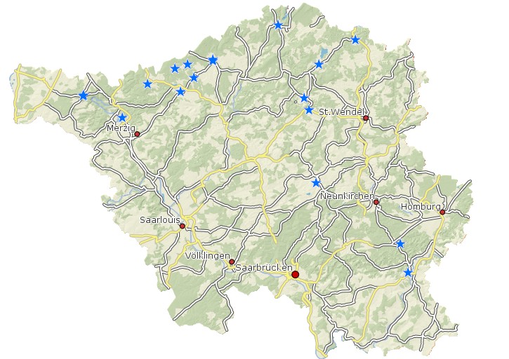
Anerkannte Kurorte und Erholungsorte Saarland
Punkthafte Darstellung der Kur- und Erholungsorte; Erfassung der Anerkannten Heilklimatischen Kurorte, Kurorte, Luftkurorte, Kneippkurorte, Erholungsorte im Saarland. Erfasssung durch das Geodatenzentrum im LVGL. Beschreibung der Attributtabelle: KURORTE----: Kurorte Gemeinden, Städte oder Gemeindebezirke STATUS-----: Status der einzelnen Orte in Heilklimatische Kurorte, Kurorte, Luftkurorte, Kneippkurorte, Erholungsorte ANERKANNT--: Anerkennungs Datum des Status HW---------: Hochwert RW---------: Rechtswert ERFASSER---: Erfasser und Datum
Simple
- Date (Creation)
- 2012-04-13
- Date (Revision)
- 2022-05-01
- Citation identifier
- https://registry.gdi-de.org/id/de.sl/93844544-be6c-4ad8-bab6-d2546f564c80
- Point of contact
-
Organisation name Individual name Electronic mail address Role Ministerium für Inneres, Bauen und Sport
Referat OBB11 Landesplanung, Bauleitplanung
poststelle@innen.saa poststelle@innen.saarland.de
Point of contact Ministerium für Inneres, Bauen und Sport
Postanschrift Ministerium für Inneres, Bauen und Sport
poststelle@inner.saa poststelle@inner.saarland.de
Resource provider Ministerium für Umwelt, Klima, Mobilität, Agrar und Verbraucherschutz
Referat E/6 Geodatenzentrum
Geodatenzentrum@umwelt.saa Geodatenzentrum@umwelt.saarland.de
Point of contact
- Resource format
-
Name Version filegdb-featureClass
10.0
-
GEMET - INSPIRE themes, version 1.0
-
-
Versorgungswirtschaft und staatliche Dienste
-
-
GEMET - Concepts, version 2.4
-
-
Ver- und Entsorgung/Nachrichtenwesen
-
- Keywords
-
-
geoportal
-
inspireidentifiziert
-
Gesundheit
-
- Keywords
-
-
Saarland
-
-
mapbender.2.inspireWholeArea
-
-
2500
-
-
mapbender.2.inspireActualCoverage
-
-
2500
-
-
Spatial scope
-
-
Regional
-
Resource constraints
Resource constraints
Resource constraints
Resource constraints
Resource constraints
Resource constraints
Resource constraints
Resource constraints
Resource constraints
Resource constraints
Resource constraints
Resource constraints
- Classification
- Unclassified
- Use limitation
-
Es gelten keine Bedingungen.
- Access constraints
- Other restrictions
- Other constraints
- Es gelten keine Zugriffsbeschränkungen
- Use constraints
- Other restrictions
- Other constraints
- Es gelten keine Bedingungen
- Other constraints
-
Die Daten unterliegen dem Urheberrecht. Jede Vervielfältigung bedarf einer Genehmigung. Die Nutzung für kommerzielle Zwecke ist nicht gestattet. Ein Quellenvermerk ist stets und bei jedweder Art der Nutzung erforderlich. Das LVGL übernimmt keine Haftung für die Vollständigkeit und die Fehlerfreiheit der Geofachdaten. Insbesondere übernimmt das LVGL keine Gewähr dafür, dass die Geofachdaten den Anforderungen und Zwecken des Nutzers genügen. Die Verantwortung für die richtige Auswahl und die Folgen der Benutzung der Geofachdaten sowie der damit beabsichtigten oder erzielten Ergebnisse trägt der Nutzer. Des Weiteren verweisen wir auf die geltenden Nutzungsbedingungen für Geofachdaten des Landesamtes für Vermessung, Geoinformation und Landentwicklung (LVGL). https://www.shop.lvgl.saarland.de/cloud/index.php/s/Nutzungsbedingungen_Geofachdaten#pdfviewer
- Spatial representation type
- Vector
- Denominator
- 5000
- Language
- Deutsch
- Character set
- UTF8
- Topic category
-
- Utilities communication
))
- Geographic identifier
- Saarland
- Unique resource identifier
- 100000000000
- Unique resource identifier
- EPSG:31466
- Distribution format
-
Name Version Esri Shape
1.0
- Distributor contact
-
Organisation name Individual name Electronic mail address Role Ministerium für Umwelt, Klima, Mobilität, Agrar und Verbraucherschutz
Referat E/6 Geodatenzentrum
Geodatenzentrum@umwelt.saa Geodatenzentrum@umwelt.saarland.de
Distributor
- OnLine resource
-
Protocol Linkage Name https://geoportal.saarland.de/layer/view/39493
- OnLine resource
-
Protocol Linkage Name https://geoportal.saarland.de/arcgis/services/Internet/Gesundheit/MapServer/WFSServer?VERSION=1.1.0&REQUEST=GetCapabilities&SERVICE=WFS
- Hierarchy level
- Dataset
Conformance result
- Date (Publication)
- 2010-12-08
- Explanation
-
Die Daten wurden mit dem EU-Validator überprüft.
- Pass
- No
- Statement
-
Erfassung durch das Referat E/6 Geodatenzentrum.
Metadata
- File identifier
- 93844544-be6c-4ad8-bab6-d2546f564c80 XML
- Metadata language
- Deutsch
- Character set
- UTF8
- Hierarchy level
- Dataset
- Date stamp
- 2023-07-03
- Metadata standard name
-
ISO19115
- Metadata standard version
-
2003/Cor.1:2006
- Metadata author
-
Organisation name Individual name Electronic mail address Role Ministerium für Umwelt, Klima, Mobilität, Agrar und Verbraucherschutz
Referat E/6 Geodatenzentrum
Geodatenzentrum@umwelt.saa Geodatenzentrum@umwelt.saarland.de
Point of contact
- Dataset URI
-
M:\suis\SUIS_GDB.gdb?ResourceName=Kur_Erhlorte
Overviews
Spatial extent
Provided by
