 JRC Geoportal External
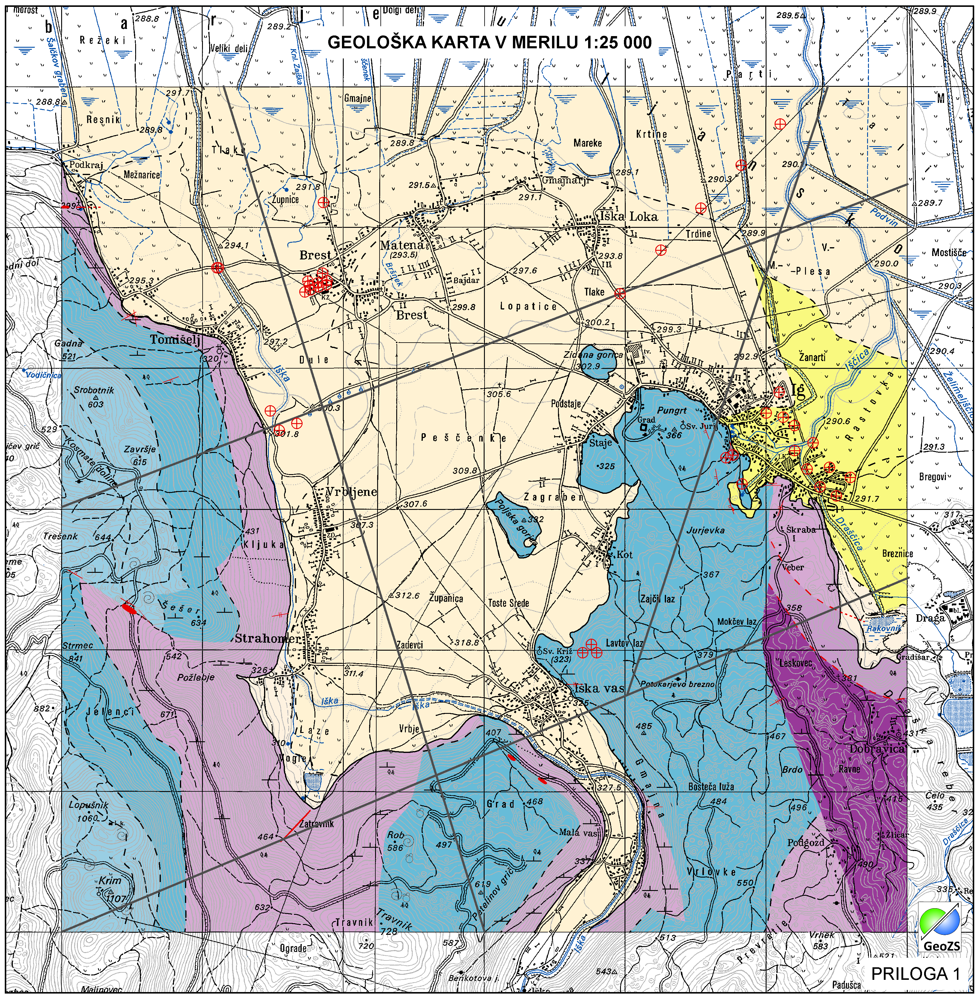
Geological map of Iška alluvial fan 1:25 000 - Geological units
Geological Units are polygons, defined by equal composition (lithology) and age.
Simple
- Alternate title
-
Geological map 1:25 000
- Alternate title
-
Geological units
- Date (Creation)
- 2014-11-18
- Date (Publication)
- 2014-11-28
- Citation identifier
- SI.GEOZS.GE25.GEOLENOTE / 1ff2643b-3a4e-4ad1-b0b5-9e97209b601e
- Presentation form
- Digital map
- Purpose
-
Displaying lithological and stratigraphic characteristics of a particular area.
- Point of contact
-
Organisation name Individual name Electronic mail address Role Geological Survey of Slovenia
info@geo-zs.si
Author Geological Survey of Slovenia
Matevž Novak, PhD
matevz.novak@geo-zs.si
Point of contact Geološki zavod Slovenije
info@geo-zs.si
Custodian
- Maintenance and update frequency
- As needed
- Discipline
-
-
geology
-
Regional geology
-
hydrogeology
-
- Theme
-
-
geology
-
lithostratigraphy
-
geological units
-
- Place
-
-
Iška alluvial fan
-
Slovenia
-
Ig
-
- Theme
-
-
INSPIRE
-
-
GEMET - INSPIRE themes, version 1.0
-
-
Geology
-
-
Spatial scope
-
-
Local
-
- Access constraints
- Copyright
- Other constraints
-
Geological map of Iška alluvial fan in scale of 1:25000. Geological map not in use "DRAFT"
- Other constraints
-
Data is available under a Creative Commons - Attribution 4.0 International (CC BY 4.0) license. ( https://creativecommons.org/licenses/by/4.0)
- Use limitation
-
Geological map not in use "DRAFT"
- Use limitation
-
Data is available under a Creative Commons - Attribution 4.0 International (CC BY 4.0) license. ( https://creativecommons.org/licenses/by/4.0)
- Spatial representation type
- Vector
- Denominator
- 25000
- Language
- slv
- Language
- slv
- Character set
- UTF8
- Topic category
-
- Geoscientific information
- Environment description
-
ArcGIS 10.1
- Description
-
Iska
))
- Begin date
- 2014-06-01
- End date
- 2014-12-31
- Reference system identifier
- MGI / Slovene National Grid (EPSG:3787)
- Reference system identifier
- WGS 84 (EPSG:4326)
- Reference system identifier
- Slovenia 1996 / Slovene National Grid (EPSG:3794)
- Reference system identifier
- http://www.opengis.net/def/crs/EPSG/0/4258
- Topology level
- Geometry only
- Distribution format
-
Name Version ESRI Shapefile
1.0
- Hierarchy level
- Dataset
Conformance result
- Date (Publication)
- 2010-12-08
- Explanation
-
Podatek je v skladu z INSPIRE za Geologijo
- Pass
- Yes
- Statement
-
Geological units
- Description
-
Geological units
Metadata
- File identifier
- 9552a47b-9d8a-40cf-bdf3-b8b300c3601b XML
- Metadata language
- slv
- Character set
- UTF8
- Hierarchy level
- Dataset
- Date stamp
- 2021-11-10T13:32:42
- Metadata standard name
-
ISO 19115:2003/19139
- Metadata standard version
-
1.0
- Metadata author
-
Organisation name Individual name Electronic mail address Role Geological Survey of Slovenia
Blaž Milanič
blaz.milanic@geo-zs.si
Point of contact
- Other language
-
Language Character encoding English
Overviews
Spatial extent
Provided by
