INSPIRE Geoportal
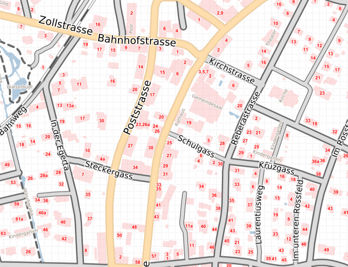
Strassenkarte auf dem Geodatenportal der Landesverwaltung
Ein aus den Daten der Amtlichen Vermessung erstellte Darstellung für eine Strassenkarte.
Die Darstellung wird im Geodatenportal der Landesverwaltung verwendet
Simple
-
Alternativtitel
-
Strassenkarte
-
Date (Création)Data (Creazione)Date (Creation)Datumsangaben (Erstellung)
- 1985-12-31
-
IdentificateurIdentificatoreCitation identifierIdentifikator
- https://metadata.geo.llv.li/9b8307da-9db2-44d6-8d50-db2216f16c86
-
Zweck
-
Geologische Untersuchung, Geologische Kartierung
-
EtatStatusStatusBearbeitungsstatus
-
FinaliséCompletatoCompletedAbgeschlossen
- Point of contact
-
Organisation name Individual name Electronic mail address Role Amt für Tiefbau und Geoinformation
Amt für Tiefbau und Geoinformation
Amt für Tiefbau und Geoinformation
Civil Engineering and Geoinformation Office
PropriétaireProprietarioOwnerEigentümer / Datenherr
-
Fréquence de mise à jourFrequenza di aggiornamentoMaintenance and update frequencyÜberarbeitungsintervall
-
Non planifiéeNon pianificatoNot plannedNicht geplant
- Resource format
-
Name Version GeoTIFF (GEOTIFF)
-
geocat.ch
-
-
INSPIRE
INSPIRE
INSPIRE
INSPIRE
-
Rasterdaten
données raster
dati raster
raster data
-
Geologische Karte
carte géologique
carta geologica
geologic map
-
-
GEMET - INSPIRE themes, version 1.0
-
-
Geologie
Géologie
Geologia
Geology
-
-
GEMET
-
-
Karte
cartogramme
mappa
map chart
-
-
Spatial scope
-
-
National
Nationales
Nazionali
National
-
-
Contraintes d'accèsVincoli di accessoAccess constraintsZugriffseinschränkungen
-
Autres restrictionsAltri vincoliOther restrictionsBenutzerdefinierte Einschränkungen
-
Andere Einschränkungen
-
no limitations to public access
-
Anwendungseinschränkungen
-
Zugangs- und Nutzungsbedingungen
-
Contraintes d'utilisationVincoli di fruibilitàUse constraintsNutzungseinschränkungen
-
Autres restrictionsAltri vincoliOther restrictionsBenutzerdefinierte Einschränkungen
-
Andere Einschränkungen
-
gebührenpflichtig
-
Type de représentation spatialeTipo di rappresentazione spazialeSpatial representation typeRäumliche Darstellungsart
-
RasterDati rasterGridRaster, Gitter
-
Distance de résolutionDistanzaDistanceDistanz
- 1.25 m
-
Langue de la ressourceLingua dei datiLanguageSprache
- Deutsch
-
Encodage des caractèresSet dei caratteri dei datiCharacter setZeichensatz
-
Utf8UTF8UTF8Utf8
-
Catégorie ISOTemaTopic categoryThematik
-
-
Sciences de la terre, géosciencesInformazioni geoscientificheGeoscientific informationGeowissenschaften
-
Étendue
Estensione
Extent
Ausdehnung
-
BeschreibungDescriptionDescrizioneDescription
-
Liechtenstein
Liechtenstein
Liechtenstein
Liechtenstein
))

-
Nom du système de référenceIdentificatore del sistema di riferimentoReference system identifierIdentifikator des Referenzsystems
-
http://www.opengis.net/def/crs/EPSG/0/21782
-
Nom du système de référenceIdentificatore del sistema di riferimentoReference system identifierIdentifikator des Referenzsystems
-
http://www.opengis.net/def/crs/EPSG/0/4936
-
DimensionsNumero delle dimensioniNumber of dimensionsAnzahl der Dimensionen
- 2
-
Type de rasterGeometria della cellaCell geometryZellengeometrie
-
SurfaceAreaAreaFläche
-
Disponibilité des paramètres de transformationDisponibilità dei coefficienti della trasformazioneTransformation parameter availabilityVerfügbarkeit von Transformationsparametern
- Distribution format
-
Name Version GeoTIFF (GEOTIFF)
Distributeur
Distributore
Distributor
Vertriebsstelle
- Distributor contact
-
Organisation name Individual name Electronic mail address Role Abt. Vermessung und Geoinformation (ATG)
Abt. Vermessung und Geoinformation (ATG)
Abt. Vermessung und Geoinformation (ATG)
Abt. Vermessung und Geoinformation (ATG)
Point de contactPunto di contattoPoint of contactAnsprechpartner
- Fees
-
Bereitstellungsgebühr CHF 60.50 pro 30 Min. sowie Nutzungsgebühr CHF 5.- pro angef. 10 Mpx
- Units of distribution
-
ganzes Land
- OnLine resource
-
Protocol Linkage Name WWW:LINK
https://geodaten.llv.li/ OGC:WMS
https://service.geo.llv.li/wmsli/service?service=WMS&language=ger&request=GetCapabilities li.atg.strassenkarte
li.atg.strassenkarte
li.atg.strassenkarte
li.atg.strassenkarte
-
NiveauLivelloHierarchy levelBezugsebene
-
Jeu de donnéesDatasetDatasetDatenbestand
Résultat de conformité
Conformità
Conformance result
Konformitätsergebnis
-
Date (Publication)Data (Pubblicazione)Date (Publication)Datumsangaben (Publikation)
- 2010-12-08
- Explanation
-
nicht bekannt
-
Degré de conformitéPassPassBestanden
- No
-
Erläuterung
-
gelogische Kartierung diverse Studenten und Doktoranden der Universit$t Bern unter der Leitung von F. Allemann
-
Beschreibung
-
Feldbegehungen, gelogische Untersuchungen
Information sur le contenu
Informazioni sul contenuto
Content Information
Dateninhalt
Metadata
-
Identifiant de la ficheIdentificatore del file di metadatiFile identifierMetadatensatzidentifikator
- 9b8307da-9db2-44d6-8d50-db2216f16c86 XML
-
LangueLingua dei metadatiMetadata languageSprache
- Deutsch
-
Jeu de caractèresSet dei caratteri dei metadatiCharacter setZeichensatz
-
Utf8UTF8UTF8Utf8
-
Type de ressourceLivello gerarchicoHierarchy levelHierarchieebene
-
Jeu de donnéesDatasetDatasetDatenbestand
-
Date des métadonnéesData dei metadatiDate stampDatum
- 2024-05-02T09:41:47.677Z
- Metadata standard name
-
GM03 2+
- Metadata author
-
Organisation name Individual name Electronic mail address Role Abt. Vermessung und Geoinformation (ATG)
Abt. Vermessung und Geoinformation (ATG)
Abt. Vermessung und Geoinformation (ATG)
Abt. Vermessung und Geoinformation (ATG)
Point de contactPunto di contattoPoint of contactAnsprechpartner
- Other language
-
Language Character encoding FrançaisFranceseFrenchFranzösischUtf8UTF8UTF8Utf8ItalienItalianoItalianItalienischUtf8UTF8UTF8Utf8AnglaisIngleseEnglishEnglischUtf8UTF8UTF8Utf8AllemandTedescoGermanDeutschUtf8UTF8UTF8Utf8