 INSPIRE Geoportal
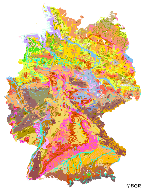
Soil Map of the Federal Republic of Germany 1:3,000,000 (WMS)
Web Map Service (WMS) of the BUEK3000. The BUEK3000 is prepared by the Federal Institute for Geosciences and Natural Resources (BGR) for the National Atlas of Germany. Based on the generalized and aggregated soil map 1:2,000,000, it shows 43 mapping units with information about soil texture, parent material, dominant and associated soils.
Simple
Identification info
- Alternate title
-
BÜK3000 (WMS)
- Date (Publication)
- 2007-12-01
- Date (Revision)
- 2003-01-01
- Citation identifier
- c337b9c9-d8c5-429a-b2e9-c28dde0150ad
- Status
- Completed
- Point of contact
-
Organisation name Individual name Electronic mail address Role Bundesanstalt für Geowissenschaften und Rohstoffe
Stegger, Ulrich
Point of contact
-
GEMET - INSPIRE themes, version 1.0
-
-
Boden
-
soil
-
-
GEMET - Concepts, version 2.4
-
-
Bodenart
-
Bodenkarte
-
Bodenkunde
-
Bodenschutz
-
Umweltschutz
-
-
Freies Schlagwort
-
-
Bodenausgangsgesteine
-
Bodeneigenschaften
-
Bodenform
-
Bodengesellschaft
-
Bodeninformationssystem
-
Bodensubstrat
-
Bodensystematik
-
Bodenübersichtskarte
-
Fachinformationssystem
-
Geografisches Informationssystem
-
infoMapAccessService
-
inspireidentifiziert
-
WMS
-
opendata
-
- Place
-
-
Bundesrepublik Deutschland
-
-
Spatial scope
-
-
National
-
- Access constraints
- Other restrictions
- Other constraints
- Es gelten keine Zugriffsbeschränkungen
- Use constraints
- Other restrictions
- Other constraints
-
Allgemeine Geschäftsbedingungen, siehe https://www.bgr.bund.de/AGB - General terms and conditions, see https://www.bgr.bund.de/AGB_en. Die bereitgestellten Informationen sind bei Weiterverwendung wie folgt zu zitieren: Datenquelle: BÜK3000 V2.1, (C) BGR, Hannover, 2014.
- Other constraints
-
Dieser Datensatz kann gemäß der "Nutzungsbestimmungen für die Bereitstellung von Geodaten des Bundes" ( https://sg.geodatenzentrum.de/web_public/gdz/lizenz/geonutzv.pdf) genutzt werden.
- Other constraints
-
Dieser Datensatz kann gemäß der "Nutzungsbestimmungen für die Bereitstellung von Geodaten des Bundes" ( https://sg.geodatenzentrum.de/web_public/gdz/lizenz/geonutzv.pdf) genutzt werden.
- Service Type
- view
- Service Version
-
OGC:WMS 1.3.0
))
- Coupled Resource
-
Operation Name Scoped name Identifier getMap
B4ECE467-8B93-413B-8338-6EA483D4F067
- Coupling Type
- Tight
- Contains Operations
-
Operation Name Distributed Computing Platforms Connect Point GetCapabilities
Web services https://services.bgr.de/wms/boden/buek3000/? GetMap
Web services https://services.bgr.de/wms/boden/buek3000/?
- Unique resource identifier
- EPSG:3035
- Distribution format
-
Name Version png
n/a
jpeg
n/a
gif
n/a
- Distributor contact
-
Organisation name Individual name Electronic mail address Role Bundesanstalt für Geowissenschaften und Rohstoffe
Distributor
- OnLine resource
-
Protocol Linkage Name https://services.bgr.de/wms/boden/buek3000/?REQUEST=GetCapabilities&SERVICE=wms&VERSION=1.3.0
- OnLine resource
-
Protocol Linkage Name https://services.bgr.de/boden/buek3000
- Hierarchy level
- Service
- Other
-
Service
Conformance result
- Date (Publication)
- 2009-10-20
- Explanation
-
siehe dazu die angegebene Durchführungsbestimmung
- Statement
-
BÜK2000 N Version 2.3. -
Metadata
- File identifier
- C3AD6569-297A-458A-B243-FCBC00B574F4 XML
- Metadata language
- Deutsch
- Character set
- UTF8
- Hierarchy level
- Service
- Hierarchy level name
-
Boden
- Date stamp
- 2020-07-22
- Metadata standard name
-
INSPIRE Metadata Implementing Rules: Technical Guidelines based on EN ISO 19115 and EN ISO 19119
- Metadata standard version
-
n/a
- Metadata author
-
Organisation name Individual name Electronic mail address Role Bundesanstalt für Geowissenschaften und Rohstoffe (BGR)
Point of contact
- Other language
-
Language Character encoding English UTF8
Overviews
Spatial extent
Provided by
