INSPIRE Geoportal
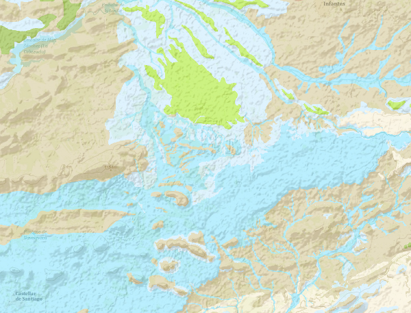
Mapa Hidrogeológico a escala 1:200.000 digital continuo de España
The continuous Hydrogeological Map of Spain in digital format at a scale of 1:200,000 is based on the Lithostratigraphic and Permeability Map of Spain, continuous at a scale of 1:200,000 and represents the mapped lithostratigraphic levels, grouped by range of permeability and the associated lithologies, and represented with a certain colour and tone, so that it is possible to visualise the areas associated with the different aquifers on the map. Blue colours represent porous aquifers, green colours represent fissured or karstic aquifers and brown colours represent impermeable or low permeability formations. Productivity is represented by the tone, in the case of permeable formations, dark tones indicate greater productivity and in the case of impermeable formations indicate greater impermeability. For the preparation of the Hydrogeological Map, once it had been verified that the formations that make up the main aquifers were cartographically differentiated on the Lithostratigraphic and Permeability Map of Spain, a hydrogeological legend was drawn up, grouping them according to their permeability, geometry, hydraulic relationship and hydrogeological functioning. This work was carried out taking into account the existing information on the different aquifers in Spain as well as the groundwater bodies defined in accordance with the Water Framework Directive (WFD). The continuous Hydrogeological Map of Spain in digital format at a scale of 1:200,000,000 arises from the need for a continuous map of the entire national territory on which to capture the information and distribution of the groundwater bodies (m.a.s). This cartography is adapted to the hydrographic network and the shadow model made by CEDEX, at a scale of 1:20,000, from the topographic base, at a scale of 1:50,000, of the Army Cartographic Service. The cartographic information is referenced to coordinates in UTM projection, European Datum, zone 30, except for the Canary Islands, which is referenced to zone 28. The Hydrogeological Map is made up of a polygonal layer of cartographic units (LPLIT) and the external tables Hidro.dat and Descrip_hidro.dat. The format of the information generated is Shape file.
Simple
- Alternate title
-
Hidrogeológico 200 digital continuo
- Date (Creation)
- 2009-04-21
- Date (Publication)
- 2009-08-05
- Edition
-
1ª Edición
- Edition date
- 2009-01-01
- Citation identifier
-
637843
Identification of the Geological Survey of Spain. Documentation Centre 1979-01-01 creation
- Citation identifier
- IGME / Hidrogeologia
- Presentation form
- Hardcopy map
- Presentation form
- Hardcopy document
- Presentation form
- Digital document
- Presentation form
- Digital map
- Purpose
-
Hydrogeological information and maps are needed to define and delimit groundwater bodies with greater precision, so that this information makes it possible to: indicate the location and limits of groundwater bodies, define the general characteristics of the overlying strata of the catchment area, sources of contamination, etc. And to carry out additional characterisation of the m.a.s. at risk where it is necessary to establish their recharge areas, the characteristics of the chemical composition of the waters, the location of groundwater abstraction points, protected areas and their characteristics. This map was prepared by means of a "Collaboration Agreement between the Ministry of the Environment (General Secretariat for Territory and Biodiversity. Directorate General for Water) and theGeological Survey of Spain for carrying out technical work in relation to the implementation of the Water Framework Directive on groundwater'' signed in 2004.
- Credit
-
Director, project coordinator: Miguel del Pozo Gómez (IGME), Vicente Fabregat Ventura (IGME), Supervisors, IGME technical-scientific staff, Contributors, IGME technical-scientific staff, EPTISA technical-scientific staff, Carried out through a collaboration agreement between the Ministry of the Environment and the IGME.
- Point of contact
-
Organisation name Individual name Electronic mail address Role Geological Survey of Spain (IGME)
Mejías Moreno, Miguel
Point of contact
- Maintenance and update frequency
- Not planned
-
IGME Thesaurus
-
-
General geology
-
geology
-
Hydrology, Hydrogeology
-
hydrogeology
-
Physical and chemical properties
-
property
-
physical property
-
permeability
-
Hydrology, Hydrogeology
-
hydrogeological map
-
Hydrology, Hydrogeology
-
groundwater
-
- Keywords
-
-
Aquifer
-
- Keywords
-
-
Groundwater body
-
- Keywords
-
-
DMA
-
- Keywords
-
-
Digital cartography
-
-
GEMET
-
-
NATURAL ENVIRONMENT, ANTHROPIC ENVIRONMENT
-
HYDROSPHERE (freshwater, seawater, waters)
-
hydrosphere
-
water (geography)
-
groundwater
-
- Specific usage
-
It aims to contribute to compliance with the Water Framework Directive and responds to the need to know the distribution of groundwater bodies in the national territory.
- User contact info
-
Organisation name Individual name Electronic mail address Role Geological Survey of Spain (IGME)
Point of contact
- Access constraints
- Other restrictions
- Other constraints
- Sin limitaciones al acceso público.
- Use constraints
- Other restrictions
- Other constraints
- CC BY 4.0 IGME-CSIC
- Title
-
Lithostatrigraphic map of Spain at a scale of 1:200.000, continuous
- Date (Publication)
- 2007-09-30
- Cited responsible party
-
Organisation name Individual name Electronic mail address Role Geological Survey of Spain (IGME)
Point of contact
- Aggregate Datasetindentifier
- 637841
- Association Type
- Larger work citation
- Title
-
Permeability Map of Spain at a scale of 1:200.000, continuous
- Date (Publication)
- 2007-09-30
- Cited responsible party
-
Organisation name Individual name Electronic mail address Role Geological Survey of Spain (IGME)
Point of contact
- Aggregate Datasetindentifier
- 637842
- Association Type
- Larger work citation
- Spatial representation type
- Vector
- Denominator
- 200000
- Language
- Spanish; Castilian
- Character set
- UTF8
- Topic category
-
- Geoscientific information
))
- Supplemental Information
-
The document "Preparation of the hydrogeological map of Spain at a scale of 1:200,000, continuous and in digital format" (2009) can be consulted in the Documentation Service, where the process of preparation and description of the information prepared is described in a precise manner. It has a consultation application and a map viewer, as well as geological and cartographic information, tables, symbology libraries and map compositions.
- Unique resource identifier
- ETRS89 coordenadas geográficas
- Unique resource identifier
- ED50 / UTM zone 30N
- Unique resource identifier
- ED50 / UTM zone 28N Pico de las Nieves
- Distribution format
-
Name Version Shapefile (.shp) 8.3.0.800
Mapa digital: JPEG -Joint Photographic Group Format -
Servicio web: WMS - Web Map Service
1.3.0
Distributor
- Distributor contact
-
Organisation name Individual name Electronic mail address Role Geological Survey of Spain (IGME)
Distributor
- Distributor format
-
Name Version Mapa digital: SHP - ArcView ShapeFile
8.3.0.800
Mapa digital: JPEG -Joint Photographic Group Format
-
Distributor
- Distributor contact
-
Organisation name Individual name Electronic mail address Role Documentation Centre of Geological Survey of Spain (IGME)
Distributor
- Distributor format
-
Name Version Mapa en papel
-
Distributor
- Distributor contact
-
Organisation name Individual name Electronic mail address Role Technical Vice-Directorate of Geological Information Systems of the Geological Survey of Spain (IGME)
Distributor
- Distributor format
-
Name Version Servicio web: WMS - Web Map Service
1.3.0
- Units of distribution
-
The Hydrogeological map of Spain is composed of: Cartographic units (LPLIT): Lithological polygonal enclosures with the cartographic units coded according to the FH field. Each enclosure or polygon has a numerical code corresponding to the geological formation according to the lithostratigraphic column (FH). Two external tables: Hidro.dat, which assigns to each lithostratigraphic unit (FH) the corresponding hydrogeological code according to type of formation and permeability (COD_HIDRO). This code will be used for the graphic representation of the information. Y Descrip_hidro.dat. Relates each lithostratigraphic formation (FH) with its corresponding formation after grouping according to hydrogeological criteria (C_HD).
- OnLine resource
-
Protocol Linkage Name OGC Web Map Service http://mapas.igme.es/gis/services/Cartografia_Tematica/IGME_Hidrogeologico_200/MapServer/WMSServer?REQUEST=GetCapabilities&SERVICE=WMS WMS visualisation service of the Hydrogeological Map of Spain at scale 1:200.000
ATOM Syndication Format https://mapas.igme.es/servicios/atom/IGMEdownloadservice.xml Download service (ATOM Feed) for Hydrogeological Map of Spain at scale 1:200.000
https://info.igme.es/cartografiadigital/geologica/mapa.aspx?parent=../tematica/tematicossingulares.aspx&Id=15&language=es Download the Hydrogeological Map of Spain at scale 1:200.000
- Name
- DVD
- Hierarchy level
- Dataset
Completeness commission
- Name of measure
-
Duplicate phenomena
- Measure description
-
Geometric and topological control using GIS application tools.
Conformance result
- Title
-
Geometric and topological control using GIS application tools.
- Date (Publication)
- 2009-08-05
Citation identifier
- Explanation
-
Digital comparative validation and visual comparative check of the original map and the digitised map. Validation with error rate & 1%.
- Pass
- Yes
Completeness omission
- Name of measure
-
Lack of phenomena
- Measure description
-
Visual spot check and cross-checking of spatial information with attribute tables.
Conformance result
- Title
-
Visual spot check and cross-checking of spatial information with attribute tables
- Date (Publication)
- 2009-08-05
Citation identifier
- Explanation
-
Digital comparative validation and visual comparative check of the original map and the digitised map. Validation with error rate & 1%.
- Pass
- Yes
Conceptual consistency
- Name of measure
-
Degree of approximation of the digital data with the conceptual model. Distribution of phenomena in classes.
- Measure description
-
Manual verification
Conformance result
- Title
-
Hydrogeological mapping data model at a scale of 1:200,000 in digital format.
- Date (Publication)
- 2003-01-01
Citation identifier
- Explanation
-
Check that the digital information is consistent with the standards that conceptually define it. Consult the standard
- Pass
- Yes
Domain consistency
- Name of measure
-
Degree of approximation of the digital data with the conceptual model. Relationships between phenomena
- Measure description
-
Automatic verification
Conformance result
- Title
-
Hydrogeological mapping data model at a scale of 1:200,000 in digital format.
- Date (Publication)
- 2003-01-01
- Explanation
-
Check that the digital information is in accordance with the standards. Consult the standard
- Pass
- Yes
Format consistency
- Name of measure
-
Grado de aproximación de los datos a la estructura física establecida
- Measure description
-
Automatic verification
Conformance result
- Title
-
Specifications for the digitisation of hydrogeological mapping.
- Date (Publication)
- 2003-01-01
- Explanation
-
Check that the digital information is in accordance with the standards. Consult the standard
- Pass
- Yes
Non quantitative attribute accuracy
- Name of measure
-
Absence of errors in the assignment of values
- Measure description
-
Comparative study with source information
Conformance result
- Title
-
Specifications for the digitalisation of the MAGNA geological cartography. Rules for the organisation of the information of the digital National Geomorphological Map.
- Date (Revision)
- 2012-02-01
- Explanation
-
Digital comparative validation and comparative visual check of the original map and the digitised map. Error rate & 1%.
- Pass
- Yes
Conformance result
Conformance result
- Statement
-
The map is based on the lithostratigraphic map and the permeability map of Spain at a scale of 1:200,000, both continuous and digital. From the information on these maps, two processes can be distinguished that give rise to the hydrogeological map. Preparation of the hydrogeological legend: this groups the different cartographic formations according to their permeabilities, geometry, hydraulic relationship and hydrogeological functioning. This work was carried out taking into account both the existing information on the different aquifers in Spain, especially the cartographic information and that relating to geometry and hydrogeological functioning, and the groundwater bodies defined in each of the basins of the national territory. With this grouping, the 436 existing lithostratigraphic formations are reduced to 182 hydrogeological formations. Once the hydrogeological grouping was achieved, each of the original lithostratigraphic formations was assigned a hydrogeological code similar to that used in the "International Hydrogeological Map of Europe 1:1,500,000". This code was established, in a simplified form, according to permeability and lithology and was represented with a certain colour and tone to allow the areas associated with the different underground aquifers to be visualised on the Hydrogeological Map. Preparation of the hydrogeological map: Each lithostratigraphic unit was assigned the corresponding hydrogeological code as specified in the previous legend. In this way, when represented on the 1:200,000 map, both the impermeable formations and the detritic or carbonate formations can be seen, which allows the hydrogeological domains to be distinguished.
- Description
-
Creation of the lithostratigraphic map: 1.- Zoning of the territory according to fundamentally geological and hydrogeological criteria. 2. Zonal legend 4.- Zonal mapping 5.- Conformation of zones (cases) 6.- Lithostratigraphic legend 7.- Lithostratigraphic Map
- Description
-
Realisation of the Permeability Map: 1.- Legend of permeabilities, 2.
- Description
-
Elaboration of the Hydrogeological Map legend: It groups the different cartographic formations according to their permeability, geometry, hydraulic relationship and hydrogeological functioning. This work was carried out taking into account both the existing information on the different aquifers in Spain, especially the cartographic information and that relating to geometry and hydrogeological functioning, and the groundwater bodies defined in each of the basins of the national territory. With this grouping, the 436 existing lithostratigraphic formations are reduced to 182 hydrogeological formations. Once the hydrogeological grouping was achieved, each of the original lithostratigraphic formations was assigned a hydrogeological code similar to that used in the "International Hydrogeological Map of Europe 1:1,500,000". This code was established, in a simplified form, according to permeability and lithology and was represented with a certain colour and tone to allow the areas associated with the different underground aquifers to be visualised on the Hydrogeological Map.
- Description
-
Elaboration of the Hydrogeological Map: The corresponding hydrogeological code is assigned as specified in the previous legend. In this way, when represented on the 1:200,000 map, both the impermeable formations and the detritic or carbonate formations can be seen, which allows the hydrogeological domains to be distinguished. To complete and facilitate consultation and understanding of the hydrogeological and permeability map, the following elements of hydrogeological interest were represented on them: groundwater bodies and surface water bodies (significant drainage network, lakes and reservoirs). All of them sent to Brussels in March 2007 for article 5 of the Water Framework Directive. River Basin Districts (land area only). Sent to Brussels in March 2007 for Article 3 of the Water Framework Directive. Hydrographic demarcation boundary between Júcar and Guadiana approved according to OM BOE 30 December 2008. Groundwater monitoring stations of the Ministry of the Environment, differentiating them according to their nature (spring, well, borehole or other) and their belonging to the following networks: Monitoring of quantitative status, Monitoring of chemical status. Operational network, Monitoring of chemical status. Surveillance network, EIONET-WATER International Monitoring Network and Monitoring of areas designated for the control of water intended for human consumption.
- Description
-
Computer processing: Integration of all the information in a Geographic Information System, establishing criteria on the characteristics of the data and its scope.
- Denominator
- 200000
- Title
-
Lithostratigraphic Map of Spain at a scale of 1:200.000 continuous
- Date (Publication)
- 2007-09-30
- Cited responsible party
-
Organisation name Individual name Electronic mail address Role IGME
Originator IGME
Distributor
- Presentation form
- Digital map
- Presentation form
- Digital table
- Denominator
- 200000
- Title
-
Map of Permeabilities of Spain at a scale of 1:200.000 continuous
- Date (Publication)
- 2010-09-30
- Cited responsible party
-
Organisation name Individual name Electronic mail address Role IGME
Originator IGME
Distributor
- Presentation form
- Digital map
- Presentation form
- Digital table
Metadata
- File identifier
- ESPIGMEHIDROGEOLOGICO200CONTINUODIGITAL20100806637843 XML
- Metadata language
- Spanish; Castilian
- Character set
- UTF8
- Hierarchy level
- Dataset
- Date stamp
- 2024-12-04
- Metadata standard name
-
Reglamento (CE) Nº 1205/2008 de INSPIRE
- Metadata standard version
-
TG 2.0
- Metadata author
-
Organisation name Individual name Electronic mail address Role Geological Survey of Spain (IGME)
Geological Information System Area
Point of contact
- Other language
-
Language Character encoding English UTF8