 INSPIRE Geoportal
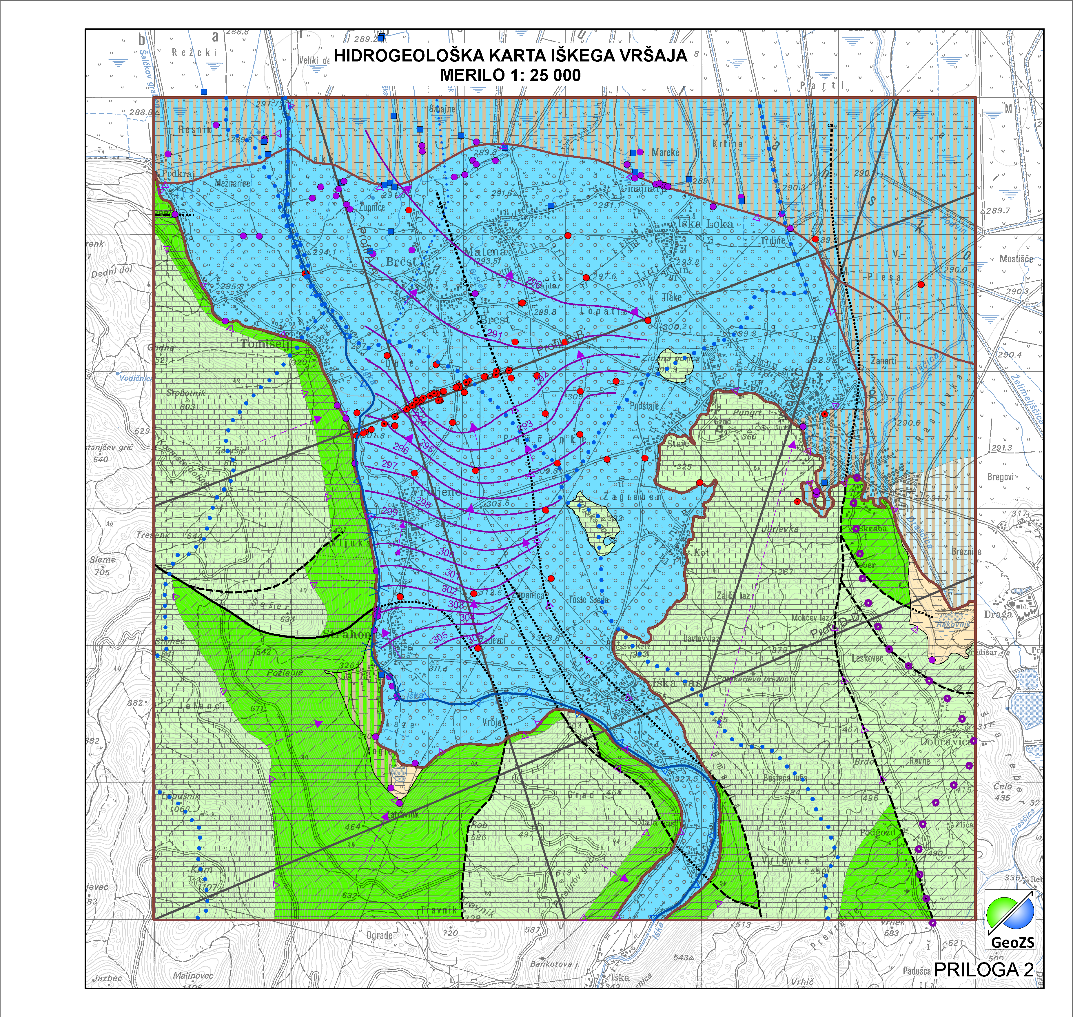
Hydrogeological map of Iška alluvial fan 1:25 000 - Aquifer Systems
Simple
-
Alternate title
-
Hydrogeological map of Iška alluvial fan 1:25 000
-
Alternate title
-
Aquifer Systems
-
Date (Creation)
- 2014-11-18
-
Date (Publication)
- 2015-01-01
-
Citation identifier
- SI.GEOZS.HG25.HGSIS /
-
Presentation form
-
Digital map
- Point of contact
-
Organisation name Individual name Electronic mail address Role Geological Survey of Slovenia
info@geo-zs.si
AuthorGeological Survey of Slovenia
Nina Mali, PhD
nina.mali@geo-zs.si
Point of contactGeološki zavod Slovenije
info@geo-zs.si
Custodian
-
Maintenance and update frequency
-
As needed
-
Discipline
-
-
hydrogeology
-
geology
-
-
Place
-
-
aquifer system
-
groundwater body
-
aquifer type
-
Iška alluvial fan
-
hydrogeological map
-
-
Place
-
-
Ig
-
Slovenia
-
-
Theme
-
-
INSPIRE
-
-
GEMET - INSPIRE themes, version 1.0
-
-
Geology
-
-
Spatial scope
-
-
Local
-
-
Access constraints
-
Copyright
-
Other constraints
-
Data is available under a Creative Commons - Attribution 4.0 International (CC BY 4.0) license. ( https://creativecommons.org/licenses/by/4.0)
-
Use limitation
-
Data is available under a Creative Commons - Attribution 4.0 International (CC BY 4.0) license. ( https://creativecommons.org/licenses/by/4.0)
-
Spatial representation type
-
Vector
-
Denominator
- 25000
-
Language
- slv
-
Language
- English
-
Character set
-
UTF8
-
Topic category
-
-
Geoscientific information
-
- Environment description
-
ArcGIS 10.1
-
Description
-
Slovenia
))
- Begin date
- 2014-06-01
- End date
- 2014-12-31
-
Reference system identifier
-
EPSG
/
MGI / Slovene National Grid (EPSG:3787)/ 7.4
-
Reference system identifier
-
EPSG
/
WGS 84 (EPSG:4326)/ 7.4
-
Reference system identifier
-
EPSG
/
Slovenia 1996 / Slovene National Grid (EPSG:3794)/ 7.4
-
Reference system identifier
-
http://www.opengis.net/def/crs/EPSG/0/4258
-
Topology level
-
Geometry only
-
Hierarchy level
-
Dataset
Conformance result
-
Date (Publication)
- 2010-12-08
- Explanation
-
Podatek je v skladu z INSPIRE za Geologijo
-
Pass
- Yes
- Statement
-
Na obravnavanem območju so bile meje vodonosnih sistemov prilagojene na merilo karte 1:25.000.
- Description
-
Vodonosni sistemi
Metadata
-
File identifier
- ae24ad88-9b0b-4aa7-b248-df670e2b92d1 XML
-
Metadata language
- slv
-
Character set
-
UTF8
-
Hierarchy level
-
Dataset
-
Date stamp
- 2021-05-06T15:58:24
- Metadata standard name
-
ISO 19115:2003/19139
- Metadata standard version
-
1.0
- Metadata author
-
Organisation name Individual name Electronic mail address Role Geological Survey of Slovenia
Matija Krivic
matija.krivic@geo-zs.si
Point of contact
- Other language
-
Language Character encoding English
Overviews
Spatial extent
Provided by
