INSPIRE Geoportal
VECTOR25
VECTOR25
VECTOR25
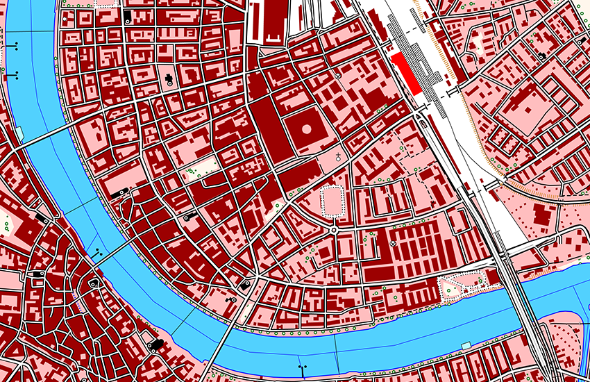
VECTOR25 ist das digitale Landschaftsmodell der Schweiz, welches inhaltlich und geometrisch auf der Landeskarte 1:25'000 basiert. VECTOR25 gibt die natürlichen und künstlichen Objekte der Landschaft im flexiblen Vektorformat wieder. VECTOR25 beschreibt rund 8.5 Millionen Objekte mit Lage, Form und ihren Nachbarschaftsbeziehungen (Topologie) sowie der Objektart und weiteren Sachattributen. VECTOR25 besteht aus 9 thematischen Ebenen: Strassennetz, Eisenbahnnetz, Übriger Verkehr, Gewässernetz, Primärflächen, Gebäude, Hecken und Bäume, Anlagen und Einzelobjekte.
VECTOR25 est le modèle numérique du paysage de la Suisse qui se base sur le contenu et la géométrie de la carte nationale au 1:25'000. VECTOR25 restitue, dans un format vectoriel flexible, les objets naturels et artificiels du territoire. VECTOR25 décrit environ 8.5 millions d'objets avec leur situation, leur forme, leur catégorie d'objets, d'autres attributs et leur relation avec leur environnement (topologie). VECTOR25 se compose de 9 couches thématiques: réseau routier, réseau ferroviaire, autres moyens de transport, réseau hydrographique, surfaces primaires, bâtiments, haies et arbres isolés, surfaces aménagées et objets isolés.
VECTOR25 is a digital lanscape model of Switzerland. The content and geometry are based on the National Map 1:25'000. VECTOR25 reproduces mandmade and natural features in a flexible vector format VECTOR25 represents about 8.5 millions features with their position, shape, features type, descriptive attributes and relationship with others features (topology). VECTOR25 consists in 9 thematic layers : Road network, Railway network, Other traffic, Hydrographic network, Primary surfaces, Buildings, Hedges and trees, Functional surfaces and Single objects.
Simple
-
Date (lastRevision)Data (lastRevision)Date (lastRevision)Datumsangaben (lastRevision)
- 2008-08-31
-
Date (Création)Data (Creazione)Date (Creation)Datumsangaben (Erstellung)
- 1995-01-01T00:00:00
-
Gemeinsamer TitelTitre collectifTitolo collettivo
-
Topografisches Landschaftsmodell (Landesvermessung)
Modèle topographique du paysage (mensuration nationale)
Modello topografico del paesaggio (misurazione nazionale)
-
EtatStatusStatusBearbeitungsstatus
-
FinaliséCompletatoCompletedAbgeschlossen
- Point of contact
-
Organisation name Individual name Electronic mail address Role Bundesamt für Landestopografie swisstopo
Office fédéral de topographie swisstopo
Ufficio federale di topografia swisstopo
Federal Office of Topography swisstopo
Point de contactPunto di contattoPoint of contactAnsprechpartnerBundesamt für Landestopografie swisstopo
Office fédéral de topographie swisstopo
Ufficio federale di topografia swisstopo
Federal Office of Topography swisstopo
PropriétaireProprietarioOwnerEigentümer / Datenherr
-
Fréquence de mise à jourFrequenza di aggiornamentoMaintenance and update frequencyÜberarbeitungsintervall
-
AnnuelleAnnualeAnnuallyJährlich
-
geocat.ch
-
-
Landschaftsmodell
modèle du territoire
modello del territorio
landscape model
-
Verkehrsnetz
réseau de transport
rete di trasporto
traffic network
-
GIS (Geografisches Informationssystem)
SIG (Système d'Information Géographique)
SIG (Sistema Informativo Geografico)
GIS (Geographic Information System)
-
Primärfläche
surface primaire
superficie primaria
primary surface
-
Aufbewahrungs- und Archivierungsplanung AAP - Bund
Planification de la conservation et de l'archivage AAP - Conféderation
Pianificazione della conservazione e dell’archiviazione AAP - Confederazione
Conservation and archiving planning AAP - Confederation
-
Geobasisdaten
géodonnées de base
geodati di base
official geodata
-
-
GEMET - INSPIRE themes, version 1.0
-
-
Produktions- und Industrieanlagen
Lieux de production et sites industriels
Produzione e impianti industriali
Production and industrial facilities
-
Gewässernetz
Hydrographie
Idrografia
Hydrography
-
Gebäude
Bâtiments
Edifici
Buildings
-
-
GEMET
-
-
Geographisches Informationssystem
système d'information géographique
sistema informativo geografico
geographic information system
-
Straßennetz
réseau routier
rete stradale
road network
-
Eisenbahnnetz
réseau ferroviaire
rete ferroviaria
railway network
-
Hecke
haie
siepe
hedge
-
-
Type de représentation spatialeTipo di rappresentazione spazialeSpatial representation typeRäumliche Darstellungsart
-
VecteurDati vettorialiVectorVektor
-
Dénominateur de l'échelleDenominatoreDenominatorMassstabszahl
- 25000
-
Langue de la ressourceLingua dei datiLanguageSprache
- Deutsch
-
Langue de la ressourceLingua dei datiLanguageSprache
- English
-
Encodage des caractèresSet dei caratteri dei datiCharacter setZeichensatz
-
Utf8UTF8UTF8Utf8
-
Catégorie ISOTemaTopic categoryThematik
-
-
Carte de référence de la couverture terrestreMappe di baseImagery base maps earth coverOberflächenbeschreibung
-
Étendue
Estensione
Extent
Ausdehnung
-
BeschreibungDescriptionDescrizioneDescription
-
Landeskarte 1:25'000
Carte nationale 1:25'000
Carta nazionale 1:25'000
National Map 1:25'000
))

-
Identifiant géographiqueidentificatore GeograficoGeographic identifierGeografischer Identifikator
-
LK25CN25CN25NM25
-
Nom du système de référenceIdentificatore del sistema di riferimentoReference system identifierIdentifikator des Referenzsystems
-
EPSG:21781EPSG:21781
-
Niveau topologieLivello di topologiaTopology levelTopologielevel
-
Topologie de réseauTopologia 1DTopology 1DLinien
-
Type de géométries des objetsOggetto di tipo geometricoGeometric object typeGeometrietyp
-
PolygoneSuperficieSurfaceFläche
-
Nombre d'objets géométriquesConteggio oggetto geometricoGeometric object countAnzahl
- 2926950
-
Type de géométries des objetsOggetto di tipo geometricoGeometric object typeGeometrietyp
-
LigneCurvaCurveLinie
-
Nombre d'objets géométriquesConteggio oggetto geometricoGeometric object countAnzahl
- 5770999
-
Type de géométries des objetsOggetto di tipo geometricoGeometric object typeGeometrietyp
-
PointPuntoPointPunkt
-
Nombre d'objets géométriquesConteggio oggetto geometricoGeometric object countAnzahl
- 2872073
- Distribution format
-
Name Version DXF
14
ESRI Shapefile
-
- OnLine resource
-
NiveauLivelloHierarchy levelBezugsebene
-
Jeu de donnéesDatasetDatasetDatenbestand
-
ErläuterungGénéralités sur la provenanceStatement
-
Inhaltlich und geometrisch auf der Landeskarte 1:25'000 basiert. Lagegenauigkeit: 3-8 m.
Se base sur le contenu et la géométrie de la carte nationale suisse au 1:25'000. Précision de position: 3-8 m.
Content and geometry based on the swiss National Map 1:25'000. Geometric precision: 3-8 m.
Metadata
-
Identifiant de la ficheIdentificatore del file di metadatiFile identifierMetadatensatzidentifikator
- aee4fe79-a583-46a1-bf46-19ee613ce415 XML
-
LangueLingua dei metadatiMetadata languageSprache
- Deutsch
-
Jeu de caractèresSet dei caratteri dei metadatiCharacter setZeichensatz
-
Utf8UTF8UTF8Utf8
-
Type de ressourceLivello gerarchicoHierarchy levelHierarchieebene
-
Jeu de donnéesDatasetDatasetDatenbestand
-
Date des métadonnéesData dei metadatiDate stampDatum
- 2022-05-13T08:02:38
- Metadata standard name
-
GM03 2+
- Metadata author
-
Organisation name Individual name Electronic mail address Role Bundesamt für Landestopografie swisstopo
Office fédéral de topographie swisstopo
Ufficio federale di topografia swisstopo
Federal Office of Topography swisstopo
Point de contactPunto di contattoPoint of contactAnsprechpartner
- Other language
-
Language Character encoding FrançaisFranceseFrenchFranzösischUtf8UTF8UTF8Utf8ItalienItalianoItalianItalienischUtf8UTF8UTF8Utf8AnglaisIngleseEnglishEnglischUtf8UTF8UTF8Utf8AllemandTedescoGermanDeutschUtf8UTF8UTF8Utf8