INSPIRE Geoportal
swissBUILDINGS3D 3.0 Beta
swissBUILDINGS3D 3.0 Beta
swissBUILDINGS3D 3.0 Beta
swissBUILDINGS3D 3.0 Beta
swissBUILDINGS3D 3.0 Beta
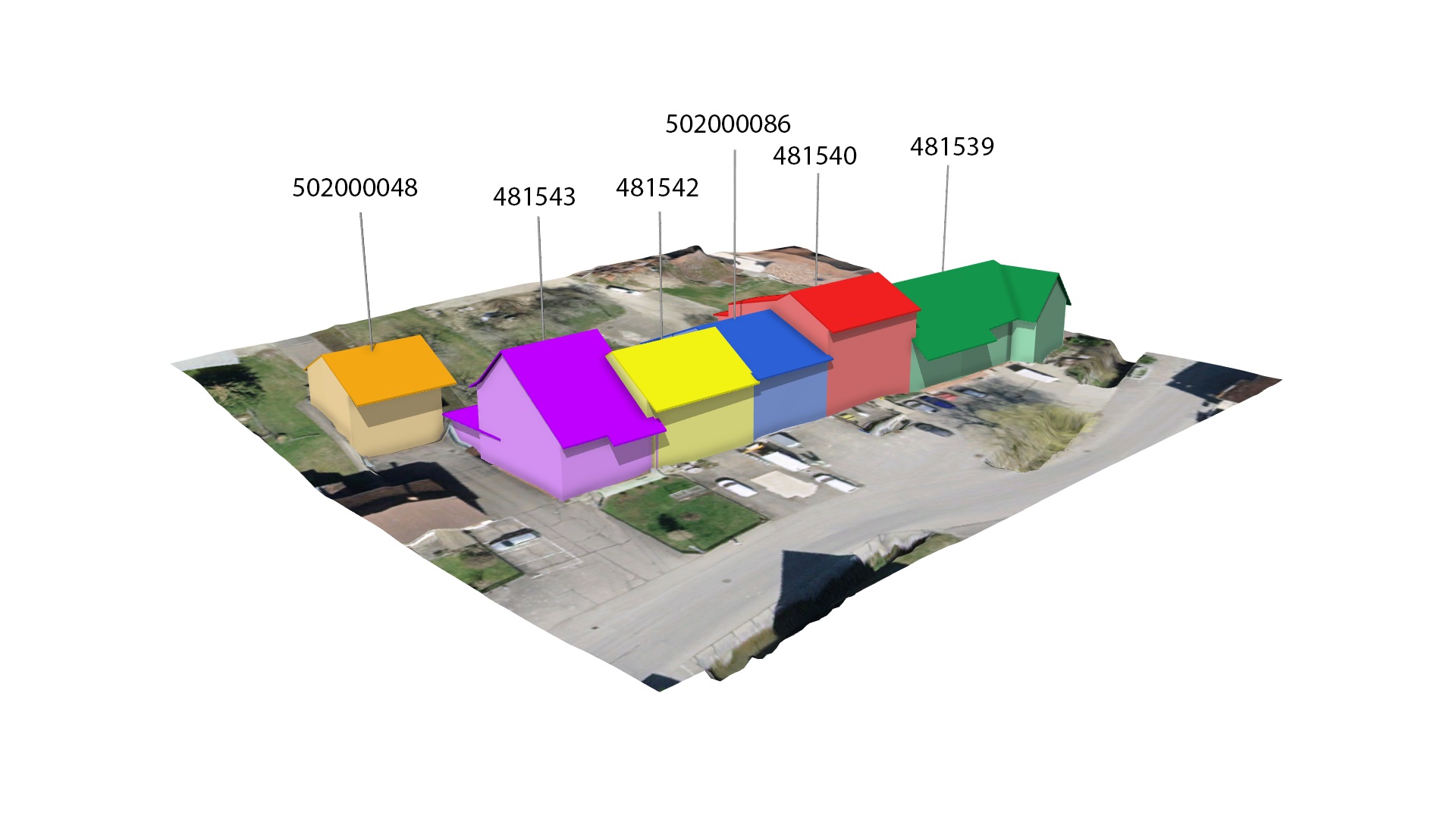
swissBUILDINGS3D 3.0 Beta ist ein Datensatz, der Gebäude als 3D-Modelle mit Dachformen und Dachüberständen darstellt. Es stehen zwei Varianten zur Verfügung: ein geschlossenes Solidmodell und ein Modell mit separaten Elementen (Dach, Fassaden und Grundriss). Für die Erstellung von 3D-Modellen in der Schweiz und Liechtenstein bietet swissBUILDINGS3D 3.0 eine nützliche Datengrundlage. Bei diesem Produkt handelt es sich um eine Weiterentwicklung von swissBUILDINGS3D 2.0.
swissBUILDINGS3D 3.0 Beta est un jeu de données qui représente les bâtiments modélisés en 3D avec les formes des toits et avant-toits. Deux variantes sont disponibles: un modèle sous forme de solides fermés et un modèle avec des éléments séparés (toits, façades et empreinte au sol). swissBUILDINGS3D 3.0 offre une base de données utile pour la création de modèles 3D en Suisse et au Liechtenstein. Il s'agit d'une version améliorée de swissBUILDINGS3D 2.0.
swissBUILDINGS3D 2.0 è un set di dati che rappresenta gli edifici sotto forma di modelli in 3D, con le forme dei tetti e le relative falde. Sono disponibili due varianti: un modello con solidi chiusi e un modello con elementi separati (tetti, facciate e impronta al suolo).swissBUILDINGS3D 3.0 offre una banca dati utile per la creazione di modelli 3D in Svizzera e Liechtenstein. È una versione migliorata di swissBUILDINGS3D 2.0.
swissBUILDINGS3D 3.0 beta is a dataset which describes buildings as 3D-models with roof geometries and roof overhangs. Two variants are available: a model with closed solids and a model with separate elements (roofs, facades and footprints). swissBUILDINGS3D 3.0 provides a useful database for the creation of 3D models in Switzerland and Liechtenstein. It is an improved version of swissBUILDINGS3D 2.0.
Simple
-
AlternativtitelAutres appellations ou acronymesTitolo alternativoAlternate titleAlternate title
-
3D-Gebäude
Les bâtiments en 3D
Gli edifici in 3D
3D buildings
Edifizis en 3D
-
Date (Publication)Data (Pubblicazione)Date (Publication)Date (Publication)Datumsangaben (Publikation)
- 2022-04-01
-
Date (Révision)Data (Revisione)Date (Revision)Date (Revision)Datumsangaben (Überarbeitung)
- 2024-11-21
-
IdentificateurIdentificatoreCitation identifierCitation identifierIdentifikator
- ch.swisstopo.swissbuildings3d_3_0
-
Gemeinsamer TitelTitre collectifTitolo collettivo
-
Topografisches Landschaftsmodell (Landesvermessung)
Modèle topographique du paysage (mensuration nationale)
Modello topografico del paesaggio (misurazione nazionale)
- Point of contact
-
Organisation name Individual name Electronic mail address Role Bundesamt für Landestopografie swisstopo
Office fédéral de topographie swisstopo
Ufficio federale di topografia swisstopo
Federal Office of Topography swisstopo
Uffizi federal da topografia swisstopo
Point de contactPunto di contattoPoint of contactPoint of contactAnsprechpartnerBundesamt für Landestopografie swisstopo
Office fédéral de topographie swisstopo
Ufficio federale di topografia swisstopo
Federal Office of Topography swisstopo
Uffizi federal da topografia swisstopo
PropriétaireProprietarioOwnerOwnerEigentümer / Datenherr
-
Fréquence de mise à jourFrequenza di aggiornamentoMaintenance and update frequencyMaintenance and update frequencyÜberarbeitungsintervall
-
Bi-annuelleSemestraleBiannuallyBiannuallyHalbjährlich
-
geocat.ch
-
-
Aufbewahrungs- und Archivierungsplanung AAP - Bund
Planification de la conservation et de l'archivage AAP - Conféderation
Pianificazione della conservazione e dell’archiviazione AAP - Confederazione
Conservation and archiving planning AAP - Confederation
-
-
geocat.ch
-
-
Geobasisdaten
géodonnées de base
geodati di base
official geodata
-
-
geocat.ch
-
-
Landschaftsmodell
modèle du territoire
modello del territorio
landscape model
-
-
geocat.ch
-
-
GIS (Geografisches Informationssystem)
SIG (Système d'Information Géographique)
SIG (Sistema Informativo Geografico)
GIS (Geographic Information System)
-
-
GEMET
-
-
Geographisches Informationssystem
système d'information géographique
sistema informativo geografico
geographic information system
-
-
GEMET - INSPIRE themes, version 1.0
-
-
Gebäude
Bâtiments
Edifici
Buildings
-
-
geocat.ch
-
-
opendata.swiss
opendata.swiss
opendata.swiss
opendata.swiss
opendata.swiss
-
BGDI Bundesgeodaten-Infrastruktur
IFDG l’Infrastructure Fédérale de données géographiques
IFDG Infrastruttura federale dei dati geografici
FSDI Federal Spatial Data Infrastructure
-
Contraintes sur la ressource
Vincoli sulla risorsa
Resource constraints
Resource constraints
Ressourceneinschränkungen
-
Andere EinschränkungenAutres contraintesAltri vincoliOther constraints
-
Opendata BY: Freie Nutzung. Quellenangabe ist Pflicht.Opendata BY: Utilisation libre. Obligation d’indiquer la source.Opendata BY: Libero utilizzo. Indicazione della fonte obbligatoria. Utilizzo a fini commerciali ammesso soltanto previo consenso del titolare dei datiOpendata BY: Open use. Must provide the source.
-
Type de représentation spatialeTipo di rappresentazione spazialeSpatial representation typeSpatial representation typeRäumliche Darstellungsart
-
VecteurDati vettorialiVectorVectorVektor
-
Langue de la ressourceLingua dei datiLanguageLanguageSprache
- Deutsch
-
Langue de la ressourceLingua dei datiLanguageLanguageSprache
- Deutsch
-
Encodage des caractèresSet dei caratteri dei datiCharacter setCharacter setZeichensatz
-
Utf8UTF8UTF8UTF8Utf8
-
Catégorie ISOTemaTopic categoryTopic categoryISO-Thematik
-
-
Constructions et ouvragesStruttureStructureStructureBauwerke
-
Étendue
Estensione
Extent
Extent
Ausdehnung
-
BeschreibungDescriptionDescrizioneDescriptionDescription
-
Liechtenstein
Liechtenstein
Liechtenstein
Liechtenstein
Liechtenstein
))

Étendue
Estensione
Extent
Extent
Ausdehnung
-
BeschreibungDescriptionDescrizioneDescriptionDescription
-
Schweiz
Suisse
Svizzera
Switzerland
Svizra
))

-
ZusatzinformationInformations supplémentairesInformazioni supplementariSupplemental InformationSupplemental Information
-
-
-
-
-
-
-
Nom du système de référenceIdentificatore del sistema di riferimentoReference system identifierReference system identifierIdentifikator des Referenzsystems
-
EPSG:2056EPSG:2056
-
Niveau topologieLivello di topologiaTopology levelTopology levelTopologielevel
-
Topologie 3DTopologia 3DTopology 3DTopology 3DKörper
-
Type de géométries des objetsOggetto di tipo geometricoGeometric object typeGeometric object typeGeometrietyp
-
VolumeSolidoSolidSolidKörper
- Distribution format
-
Name Version ESRI File Geodatabase FileGDB (GDB)
AutoCAD DWG (DWG)
City Geography Markup Language (CityGML)
-
- OnLine resource
-
Protocol Linkage Name WWW:LINK
https://www.swisstopo.admin.ch/de/landschaftmodell-swissbuildings3d-3-0-beta swissBUILDINGS3D 3.0
WWW:DOWNLOAD-URL
https://www.swisstopo.admin.ch/de/landschaftmodell-swissbuildings3d-3-0-beta OPENDATA:SWISS
https://opendata.swiss/de/perma/b9e8adf5-cb86-40cd-b969-c7e877445b3d@bundesamt-fur-landestopografie-swisstopo Permalink opendata.swiss
Permalink opendata.swiss
Permalink opendata.swiss
Permalink opendata.swiss
Permalink opendata.swiss
-
NiveauLivelloHierarchy levelHierarchy levelBezugsebene
-
Jeu de donnéesDatasetDatasetDatasetDatenbestand
-
Erläuterung
-
-
-
Inclus dans le jeu de donnéesIncluded with datasetIncluded with datasetIncluded with datasetIm Datenbestand enthalten
- No
-
TitelTitreTitoloTitleTitle
-
swissBUILDINGS3D 3.0 Beta
swissBUILDINGS3D 2.0
swissBUILDINGS3D 2.0
swissBUILDINGS3D 2.0
swissBUILDINGS3D 2.0
-
Date (Création)Data (Creazione)Date (Creation)Date (Creation)Datumsangaben (Erstellung)
- 2022-04-01
-
Date (Révision)Data (Revisione)Date (Revision)Date (Revision)Datumsangaben (Überarbeitung)
- 2024-11-21
Metadata
-
Identifiant de la ficheIdentificatore del file di metadatiFile identifierFile identifierMetadatensatzidentifikator
- b9e8adf5-cb86-40cd-b969-c7e877445b3d XML
-
LangueLingua dei metadatiMetadata languageMetadata languageSprache
- Deutsch
-
Jeu de caractèresSet dei caratteri dei metadatiCharacter setCharacter setZeichensatz
-
Utf8UTF8UTF8UTF8Utf8
-
Type de ressourceLivello gerarchicoHierarchy levelHierarchy levelHierarchieebene
-
Jeu de donnéesDatasetDatasetDatasetDatenbestand
-
Date des métadonnéesData dei metadatiDate stampDate stampDatum
- 2024-11-20T15:06:36.369Z
- Metadata standard name
-
GM03 2+
- Metadata author
-
Organisation name Individual name Electronic mail address Role Bundesamt für Landestopografie swisstopo
Office fédéral de topographie swisstopo
Ufficio federale di topografia swisstopo
Federal Office of Topography swisstopo
Uffizi federal da topografia swisstopo
Point de contactPunto di contattoPoint of contactPoint of contactAnsprechpartner
- Other language
-
Language Character encoding FrançaisFranceseFrenchFrenchFranzösischUtf8UTF8UTF8UTF8Utf8ItalienItalianoItalianItalianItalienischUtf8UTF8UTF8UTF8Utf8AnglaisIngleseEnglishEnglishEnglischUtf8UTF8UTF8UTF8Utf8RomancheRomancioRomanshRomanshRätoromanischUtf8UTF8UTF8UTF8Utf8AllemandTedescoGermanGermanDeutschUtf8UTF8UTF8UTF8Utf8