INSPIRE Geoportal
Light Base Map (Vector Tiles)
Light Base Map (Vector Tiles)
Light Base Map (Vector Tiles)
Light Base Map (Vector Tiles)
Light Base Map (Vector Tiles)
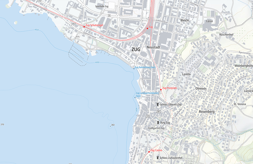
Die «Leichte Basiskarte» ist eine visuell und inhaltlich reduzierte Hintergrundkarte, welche die wichtigsten topographischen Objekte und Namen angepasst an die jeweilige Zoomstufe darstellt. Sie baut auf amtlichen Daten auf: dem topografischen Landschaftsmodell, dem digitalen Höhenmodell, den digitalen kartografischen Modellen, den Haltestellen des öffentlichen Verkehrs und dem amtlichen Verzeichnis der Strassen. Der Inhalt variiert je nach Zoomstufe. Die Vektordarstellung basiert auf der Maplibre Style Spezifikation. Vektorkacheln (Vector Tiles) bilden die Datengrundlage. Sie sind nach dem OpenMapTiles Schema strukturiert. Für das Relief wird die vektorielle Geländedarstellung (Vector Tiles) genutzt. Im Ausland werden von openmaptiles.org zur Verfügung gestellte Vector Tiles aus Open Street Map verwendet.
La «Carte de base légère» est une carte de fond au visuel et au contenu réduit et qui affiche les noms et les éléments topographiques les plus importants selon différents niveaux de zoom. Elle est construite sur des données officielles: le modèle topographique du paysage, le modèle altimétrique numérique, les modèles cartographiques numériques, les arrêts de transports publics et le répertoire officiel des rues. La représentation vectorielle est basée sur la spécification Maplibre Style. Des tuiles vectorielles (vector tiles) servent de source de données. Elles sont structurées selon le OpenMapTiles schema. Pour le relief, on utilise la représentation vectorielle du relief (Vector Tiles). Pour l'étranger, des tuiles vectorielles basées Open Street Map sont utilisées. Elles sont fournies par openmaptiles.org.
La «carta di base leggera» è una carta di sfondo visivamente e contenutisticamente ridotta che mostra gli oggetti topografici più importanti e i nomi adattati al rispettivo livello di zoom. Si basa su dati ufficiali: il modello topografico del paesaggio, il modello altimetrico digitale, i modelli cartografici digitali, le fermate dei mezzi di trasporto pubblici e l'elenco ufficiale delle strade. Il contenuto varia a seconda del livello di zoom. La rappresentazione vettoriale è basata sulla specifica Maplibre Style. Le caselle vettoriali formano la base dei dati. Sono strutturate secondo lo schema OpenMapTiles. Per il rilievo si utilizza la rappresentazione vettoriale del rilievo (Vector Tiles). All'estero, vengono utilizzate caselle vettoriali di Open Street Map messe a disposizione da openmaptiles.org.
«Light base map» is a visually and content reduced base map, which represents the most relevant topographic features and names adapted to the respective zoom level. It is constructed on the basis of official data: the topographic landscape model, the digital elevation model, digital cartographic models, public transportation stops and official street registry. The vector representation is based on the Maplibre Style Specification. The map uses vector tiles as data source. They are structured according to the OpenMapTiles schema. For the relief, the vector representation of relief (Vector Tiles) is used. For foreign countries, vector tiles based on Open Street Map are used. They are provided by openmaptiles.org.
La «charta da basa ligera» è ina charta dal fund reducida visualmain e tematicamain che mussa ils objects ed ils nums topografics ils pli impurtants en ina moda adattada al stgalim da zoom respectiv. Ella sa basa sin datas uffizialas: sin il model topografic da la cuntrada, sin il model digital da l'autezza, sin ils models cartografics digitals, sin las fermadas dal traffic public e sin il register uffizial da las vias. Il cuntegn variescha tut tenor il stgalim da zoom. La preschentaziun vectoriala sa basa sin la specificaziun «Mapbox Style». Quadrels vectorials (vector tiles) furman la basa da las datas. Els èn structurads tenor il schema OpenMapTiles. Il reliev vegn mussà cun quadrels vectorials. A l'exteriur vegnan duvrads vector tiles or dad Open Street Map che vegnan mess a disposiziun dad openmaptiles.org.
Simple
-
AlternativtitelAutres appellations ou acronymesTitolo alternativoAlternate titleAlternate title
-
Light Base Map
Light Base Map
Light Base Map
Light Base Map
Light Base Map
-
Date (Création)Data (Creazione)Date (Creation)Date (Creation)Datumsangaben (Erstellung)
- 2019-02-01
-
Date (Révision)Data (Revisione)Date (Revision)Date (Revision)Datumsangaben (Überarbeitung)
- 2023-09-12
- Edition
-
3.0.1
-
IdentificateurIdentificatoreCitation identifierCitation identifierIdentifikator
- ch.swisstopo.leichte-basiskarte.vt
Identificateur
Identificatore
Citation identifier
Citation identifier
Identifikator
-
Gemeinsamer TitelTitre collectifTitolo collettivoCollective title
-
Landesvermessung
mensuration nationale
misurazione nazionale
National survey
-
EtatStatusStatusStatusBearbeitungsstatus
-
Mise à jour continueIn corsoOn goingOn goingKontinuierliche Aktualisierung
- Point of contact
-
Organisation name Individual name Electronic mail address Role Bundesamt für Landestopografie swisstopo
Office fédéral de topographie swisstopo
Ufficio federale di topografia swisstopo
Federal Office of Topography swisstopo
Uffizi federal da topografia swisstopo
Point de contactPunto di contattoPoint of contactPoint of contactAnsprechpartnerBundesamt für Landestopografie swisstopo
Office fédéral de topographie swisstopo
Ufficio federale di topografia swisstopo
Federal Office of Topography swisstopo
Uffizi federal da topografia swisstopo
PropriétaireProprietarioOwnerOwnerEigentümer / Datenherr
-
Fréquence de mise à jourFrequenza di aggiornamentoMaintenance and update frequencyMaintenance and update frequencyÜberarbeitungsintervall
-
AnnuelleAnnualeAnnuallyAnnuallyJährlich
-
geocat.ch
-
-
Geobasisdaten
géodonnées de base
geodati di base
official geodata
-
Basiskarte
carte de base
carta di base
base map
-
BGDI Bundesgeodaten-Infrastruktur
IFDG l’Infrastructure Fédérale de données géographiques
IFDG Infrastruttura federale dei dati geografici
FSDI Federal Spatial Data Infrastructure
-
-
GEMET - INSPIRE themes, version 1.0
-
-
Geografische Bezeichnungen
Dénominations géographiques
Nomi geografici
Geographical names
-
-
AnwendungseinschränkungenLimitation d'utilisationLimitazione d’usoUse limitation
-
Nutzungseinschränkung:
Der Geodienst «Mapbox Vector Tiles» unterliegt einer Nutzungseinschränkung aufgrund der Verwendung von OpenMaptiles-Daten. Die weltweiten Daten können aus Lizenzgründen nur durch Verwaltungseinheiten der zentralen Bundesverwaltung gemäss der Anhang 1 der Regierungs- und Verwaltungsorganisationsverordnung (Anhang 1 RVOV, SR 172.010.1) genutzt werden. Für Nutzer ausserhalb der Bundesverwaltung stehen die Vector Tilesets innerhalb der Schweiz und Liechtenstein kostenlos als Dienst zur Verfügung.
Restriction d’utilisation :
Le géoservice « Mapbox Vector Tiles » est soumis à une restriction d’utilisation en raison de l’utilisation des données OpenMaptiles. Pour des raisons de licence, les données mondiales ne peuvent être utilisées que par des unités administratives de l'administration fédérale centrale, conformément à l'annexe 1 de l'ordonnance sur l'organisation du gouvernement et de l'administration (annexe 1 OLOGA, RS 172.010.1). Pour les utilisateurs en dehors de l’administration fédérale, les vector tilesets (jeux de tuiles vectorielles) sont disponibles gratuitement en Suisse et au Liechtenstein.
Limitazione d’uso:
Il geoservizio «Mapbox Vector Tiles» è soggetto a una limitazione d’uso per via dell’utilizzo dei dati OpenMaptiles. Per motivi di licenza, i dati globali possono essere usati solo dalle unità amministrative dell'Amministrazione federale centrale in conformità all'Allegato 1 dell'Ordinanza sull'organizzazione del governo e dell'amministrazione (Allegato 1 OLOGA, RS 172.010.1). Per gli utenti al di fuori dell’Amministrazione federale, i vector tileset sono disponibili gratuitamente quale servizio all’interno della Svizzera e del Principato del Liechtenstein.
Restrictions of use:
The "Mapbox Vector Tiles" geoservice has usage restrictions imposed due to the incorporation of OpenMaptiles data. As per licensing requirements, the global data can only be utilised by administrative units of the Swiss central federal administration, following specification in Annex 1 of the Government and Administration Organisation Ordinance (Annex 1 RVOV, SR 172.010.1). However, users outside the Federal Administration can access the vector tilesets covering Switzerland and Liechtenstein provided by swisstopo free of charge.
-
Contraintes d'utilisationVincoli di fruibilitàUse constraintsUse constraintsNutzungseinschränkungen
-
Autres restrictionsAltri vincoliOther restrictionsOther restrictionsBenutzerdefinierte Einschränkungen
-
Andere EinschränkungenAutres contraintesOther constraints
-
Quellangabe erforderlich: Bundesamt für Landestopografie, © OpenStreetMap contributorsMention de la source requise : office fédéral de topographie, © OpenStreetMap contributorsSource reference required: Office federal of topography, © OpenStreetMap contributors
-
Andere EinschränkungenAutres contraintesAltri vincoliOther constraints
-
Allgemeine Nutzungsbedingungen der Bundes Geodaten-Infrastruktur BGDIConditions générales d’utilisation et d’exploitation de l’Infrastructure fédérale de données géographiques IFDGCondizioni generali di utilizzo e disposizioni operative dell’infrastruttura federale di dati geografici (IFDG)General Terms of Use and Operating Conditions of the Federal Spatial Data Infrastructure FSDI
-
Type de représentation spatialeTipo di rappresentazione spazialeSpatial representation typeSpatial representation typeRäumliche Darstellungsart
-
VecteurDati vettorialiVectorVectorVektor
-
Dénominateur de l'échelleDenominatoreDenominatorDenominatorMassstabszahl
- 5000
-
Dénominateur de l'échelleDenominatoreDenominatorDenominatorMassstabszahl
- 1000000
-
Langue de la ressourceLingua dei datiLanguageLanguageSprache
- English
-
Encodage des caractèresSet dei caratteri dei datiCharacter setCharacter setZeichensatz
-
Utf8UTF8UTF8UTF8Utf8
-
Catégorie ISOTemaTopic categoryTopic categoryThematik
-
-
Carte de référence de la couverture terrestreMappe di baseImagery base maps earth coverImagery base maps earth coverOberflächenbeschreibung
-
Étendue
Estensione
Extent
Extent
Ausdehnung
-
BeschreibungDescriptionDescrizioneDescriptionDescription
-
Landeskarte 1:1'000'000
Carte nationale 1:1'000'000
Carta nazionale 1:1'000'000
National map 1:1'000'000
Landeskarte 1:1'000'000
))

-
Identifiant géographiqueidentificatore GeograficoGeographic identifierGeographic identifierGeografischer Identifikator
-
LK1000CN1000CN1000NM1000LK1000
-
ZusatzinformationInformations supplémentairesInformazioni supplementariSupplemental Information
-
Weltweite Ausdehnung (siehe Nutzungseinschränkung)
Extension mondiale (voir restriction d'utilisation)
Espansione globale (vedi limitazioni d'uso)
Global expansion (see restriction of use)
-
Nom du système de référenceIdentificatore del sistema di riferimentoReference system identifierReference system identifierIdentifikator des Referenzsystems
-
EPSG:3857EPSG:3857EPSG:3857EPSG:3857
- Distribution format
-
Name Version Mapbox GL JS
-
- OnLine resource
-
Protocol Linkage Name WWW:LINK
https://www.swisstopo.admin.ch/de/geodata/maps/smw/smw_lightbase.html WWW:LINK
https://www.geo.admin.ch/de/geo-dienstleistungen/geodienste/darstellungsdienste-webmapping-webgis-anwendungen/vector_tiles_service.html Web Service description
WWW:LINK
https://api3.geo.admin.ch/services/sdiservices.html#mapbox-vector-tiles
Metadata
-
Identifiant de la ficheIdentificatore del file di metadatiFile identifierFile identifierMetadatensatzidentifikator
- c593018b-0bb2-4b7c-81e7-21071bc47b08 XML
-
LangueLingua dei metadatiMetadata languageMetadata languageSprache
- Deutsch
-
Jeu de caractèresSet dei caratteri dei metadatiCharacter setCharacter setZeichensatz
-
Utf8UTF8UTF8UTF8Utf8
-
Type de ressourceLivello gerarchicoHierarchy levelHierarchy levelHierarchieebene
-
Jeu de donnéesDatasetDatasetDatasetDatenbestand
-
Date des métadonnéesData dei metadatiDate stampDate stampDatum
- 2023-09-14T11:39:32.219Z
- Metadata standard name
-
GM03 2+
- Metadata author
-
Organisation name Individual name Electronic mail address Role Bundesamt für Landestopografie swisstopo
Office fédéral de topographie swisstopo
Ufficio federale di topografia swisstopo
Federal Office of Topography swisstopo
Uffizi federal da topografia swisstopo
Point de contactPunto di contattoPoint of contactPoint of contactAnsprechpartner
- Other language
-
Language Character encoding FrançaisFranceseFrenchFrenchFranzösischUtf8UTF8UTF8UTF8Utf8ItalienItalianoItalianItalianItalienischUtf8UTF8UTF8UTF8Utf8AnglaisIngleseEnglishEnglishEnglischUtf8UTF8UTF8UTF8Utf8RomancheRomancioRomanshRomanshRätoromanischUtf8UTF8UTF8UTF8Utf8AllemandTedescoGermanGermanDeutschUtf8UTF8UTF8UTF8Utf8