 INSPIRE Geoportal
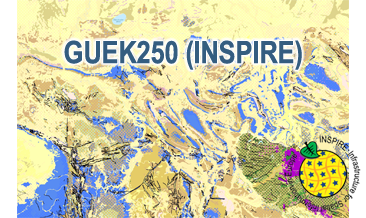
INSPIRE: The General Geological Map of the Federal Republic of Germany 1:250,000 (GÜK250) (WMS)
The WMS GÜK250 (INSPIRE) represents the surface geology of Germany on a scale of 1:250,000. In general, the term “surface geology” refers to geologic formations up to a depth of two meters. However, particularly in the south of Germany, considerable deviations of this concept exist and thicknesses of a couple of hundred meters may be displayed. According to the Data Specification on Geology (D2.8.II.4_v3.0) the geological map provides INSPIRE-compliant data. The GÜK250 (INSPIRE) contains a base layer and an overlay layer which usually represents thin Quaternary deposits.
The WMS GÜK250 (INSPIRE) contains correspondingly two layers for the geologic units (GE.GeologicUnit.BaseLayer and GE.GeologicUnit.OverlayLayer). Additionally the WMS comprises layers representing the faults (GE.GeologicFault), marginal position of the ice shield (GE. NaturalGeomorphologicFeature) and quartz veins (GE.GeologicUnit.QuartzVein). The layers are mostly displayed according to the INSPIRE portrayal rules. The geologic units are represented graphically by stratigraphy (GE.GeologicUnit.BaseLayer.AgeOfRocks and GE.GeologicUnit.OverlayLayer.AgeOfRocks, stored in group layer GE.AgeOfRocks) and lithology (GE.GeologicUnit.BaseLayer.Lithology and GE.GeologicUnit.OverlayLayer.Lithology, stored in group layer GE.Lithology). Because INSPIRE doesn’t provide portrayal rules for the genesis (event process und event environment), this display mode is not available compared to the original WMS GÜK250. In case of different geochronologic minimum and maximum ages, e.g. Pleistocene - Holocene, the portrayal is defined by the colour of the geochronologic minimum age (olderNamedAge). The portrayal of the lithology is defined by the rock or rock group representing the main part of the petrographic composition of the geologic unit. For the portrayal of different petrographic main components the corresponding colours are superimposed in a dot pattern. Analogous to the original WMS GÜK250 the petrographic content is represented graphically according to the generic terms of the main components, e.g. clastic sedimentary rock, pure carbonate sedimentary rock or metamorphic rock. In case of the geologic units the user obtains detailed information on the stratigraphy, lithology and genesis via the getFeatureInfo request.
Simple
Identification info
- Alternate title
-
GÜK250 (WMS) (INSPIRE)
- Date (Publication)
- 2020-05-13
- Citation identifier
- https://registry.gdi-de.org/id/de.bund.bgr.csw/17d48f35-702c-5602-148b-b8c966fd2935
- Status
- Completed
- Point of contact
-
Organisation name Individual name Electronic mail address Role Bundesanstalt für Geowissenschaften und Rohstoffe (BGR)
Point of contact
-
GEMET - INSPIRE themes, version 1.0
-
-
Geologie
-
Geology
-
- Theme
-
-
Allgemeine Geologie
-
Eisrandlagen
-
Genese
-
Petrographie
-
Tektonik
-
Geologische Karte
-
Quarzgänge
-
Stratigraphie
-
Vektordaten
-
infoMapAccessService
-
inspireidentifiziert
-
opendata
-
- Place
-
-
Germany
-
Deutschland
-
-
Spatial scope
-
-
National
-
- Access constraints
- Other restrictions
- Other constraints
- Es gelten keine Zugriffsbeschränkungen
- Use constraints
- Other restrictions
- Other constraints
-
General Terms and Conditions, s. https://www.bgr.bund.de/agb_en
- Other constraints
-
Dieser Datensatz kann gemäß der "Nutzungsbestimmungen für die Bereitstellung von Geodaten des Bundes" ( https://sg.geodatenzentrum.de/web_public/gdz/lizenz/geonutzv.pdf) genutzt werden.
- Service Type
- view
- Service Version
-
OGC:WMS 1.3.0
))
- Coupled Resource
-
Operation Name Scoped name Identifier getMap
https://registry.gdi-de.org/id/de.bund.bgr.csw/2597669d-d0ec-3e32-3996-d7b07c801f4e
- Coupling Type
- Tight
- Contains Operations
-
Operation Name Distributed Computing Platforms Connect Point GetCapabilities
Web services https://services.bgr.de/wms/inspire_ge/guek250/? GetMap
Web services https://services.bgr.de/wms/inspire_ge/guek250/?
- Unique resource identifier
- EPSG:25832
- Distribution format
-
Name Version png
n/a
jpeg
n/a
gif
n/a
- OnLine resource
-
Protocol Linkage Name https://services.bgr.de/wms/inspire_ge/guek250/?REQUEST=GetCapabilities&SERVICE=wms&VERSION=1.3.0
- OnLine resource
-
Protocol Linkage Name https://services.bgr.de/inspire/guek250
- Hierarchy level
- Service
- Other
-
Service
Conformance result
- Date (Publication)
- 2013-04-04
- Explanation
-
See the referenced specification
- Pass
- Yes
Conformance result
- Date (Publication)
- 2009-10-20
- Explanation
-
See the referenced specification
- Statement
-
The WMS GÜK250 (INSPIRE) is based on the spatial dataset of the General Geological Map of the Federal Republic of Germany 1:250,000 (GÜK250) transformed according to INSPIRE.
Metadata
- File identifier
- cf2c54d6-1412-462c-9271-6307bfc4ba48 XML
- Metadata language
- English
- Character set
- UTF8
- Hierarchy level
- Service
- Hierarchy level name
-
Geologie
- Hierarchy level name
-
INSPIRE
- Date stamp
- 2020-07-15
- Metadata standard name
-
ISO19115/ISO19119
- Metadata standard version
-
n/a
- Metadata author
-
Organisation name Individual name Electronic mail address Role Bundesanstalt für Geowissenschaften und Rohstoffe (BGR)
Point of contact
- Other language
-
Language Character encoding German UTF8 English UTF8
Overviews
Spatial extent
Provided by
