INSPIRE Geoportal
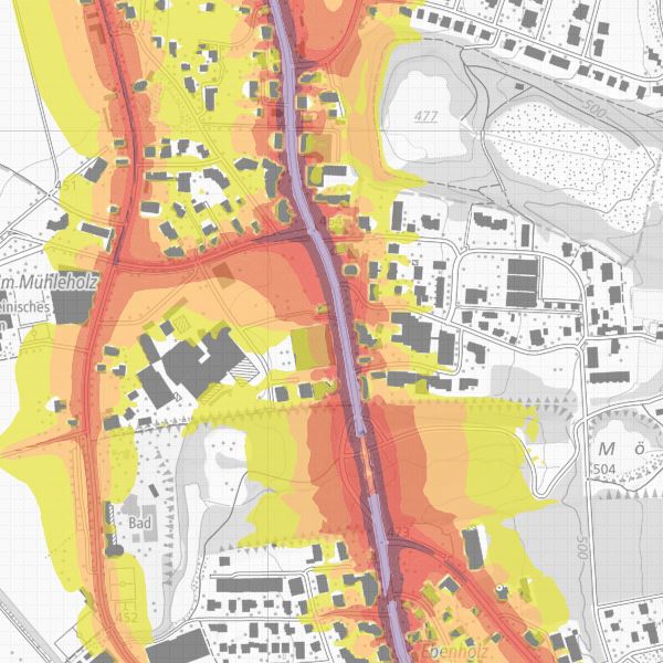
Strategische Lärmkarte - Lärmbelastung LDEN
Ergänzend zu den Resultaten der Lärmkataster auf der Basis der liechtensteinischen Lärmschutzverordnung stellen die strategischen Lärmkarten (Richtlinie 2002/49/EG des Europäischen Parlaments und des Rates vom 25. Juni 2002) eine Grundlage für die Vergleichbarkeit der Lärmsituation in den europäischen Ländern zur Verfügung. Die strategischen Lärmkarten zeigen das Ausmass der Lärmbelastung an den hochfrequentierten Landstrassen und sind somit die Grundlage für die Aktionsplanung gemäss der Richtlinie 2002/49/EG.
Simple
-
Alternativtitel
-
Strategische Lärmkarten
-
Date (Création)Data (Creazione)Date (Creation)Datumsangaben (Erstellung)
- 2013-11-13
-
IdentificateurIdentificatoreCitation identifierIdentifikator
- https://metadata.geo.llv.li/d338075d-85c3-405c-a2bf-56ca668438e3
-
Zweck
-
Lärmschutz
-
EtatStatusStatusBearbeitungsstatus
-
FinaliséCompletatoCompletedAbgeschlossen
- Point of contact
-
Organisation name Individual name Electronic mail address Role Abt. Vermessung und Geoinformation (ATG)
Abt. Vermessung und Geoinformation (ATG)
Abt. Vermessung und Geoinformation (ATG)
Abt. Vermessung und Geoinformation (ATG)
Point de contactPunto di contattoPoint of contactAnsprechpartnerAmt für Umwelt
Office pour l'environnement
Ufficio per l'ambiente
Office for the Environment
Point de contactPunto di contattoPoint of contactAnsprechpartner
-
Fréquence de mise à jourFrequenza di aggiornamentoMaintenance and update frequencyÜberarbeitungsintervall
-
Lorsque nécessaireSecondo necessitàAs neededBei Bedarf
-
GEMET
-
-
Vektor
vecteur
vettore
vector
-
Umweltpolitik
politique environnementale
politica ambientale
environmental policy
-
Lärm, Erschütterungen
bruit, vibrations
rumore, vibrazioni
noise, vibrations
-
Lärmbelastung
polluant sonore
inquinante acustico
noise pollutant
-
-
geocat.ch
-
-
INSPIRE
INSPIRE
INSPIRE
INSPIRE
-
Strassenlärm
bruit routier
rumore stradale
road noise
-
-
GEMET - INSPIRE themes, version 1.0
-
-
Gesundheit und Sicherheit
Santé et sécurité des personnes
Salute umana e sicurezza
Human health and safety
-
Verkehrsnetze
Réseaux de transport
Reti di trasporto
Transport networks
-
-
Contraintes d'accèsVincoli di accessoAccess constraintsZugriffseinschränkungen
-
Autres restrictionsAltri vincoliOther restrictionsBenutzerdefinierte Einschränkungen
-
Andere Einschränkungen
-
no limitations to public access
-
Anwendungseinschränkungen
-
Zugangs- und Nutzungsbedingungen
-
Contraintes d'utilisationVincoli di fruibilitàUse constraintsNutzungseinschränkungen
-
Autres restrictionsAltri vincoliOther restrictionsBenutzerdefinierte Einschränkungen
-
Andere Einschränkungen
-
gebührenpflichtig
-
Type de représentation spatialeTipo di rappresentazione spazialeSpatial representation typeRäumliche Darstellungsart
-
VecteurDati vettorialiVectorVektor
-
Dénominateur de l'échelleDenominatoreDenominatorMassstabszahl
- 500
-
Langue de la ressourceLingua dei datiLanguageSprache
- Deutsch
-
Encodage des caractèresSet dei caratteri dei datiCharacter setZeichensatz
-
Utf8UTF8UTF8Utf8
-
Catégorie ISOTemaTopic categoryThematik
-
-
EnvironnementAmbienteEnvironmentUmwelt
-
Étendue
Estensione
Extent
Ausdehnung
-
BeschreibungDescriptionDescrizioneDescription
-
Liechtenstein
Liechtenstein
Liechtenstein
Liechtenstein
))

-
Nom du système de référenceIdentificatore del sistema di riferimentoReference system identifierIdentifikator des Referenzsystems
-
http://www.opengis.net/def/crs/EPSG/0/21782http://www.opengis.net/def/crs/EPSG/0/4936http://www.opengis.net/def/crs/EPSG/0/4936http://www.opengis.net/def/crs/EPSG/0/4936
-
Nom du système de référenceIdentificatore del sistema di riferimentoReference system identifierIdentifikator des Referenzsystems
-
http://www.opengis.net/def/crs/EPSG/0/4936http://www.opengis.net/def/crs/EPSG/0/4936http://www.opengis.net/def/crs/EPSG/0/4936http://www.opengis.net/def/crs/EPSG/0/4936
-
Niveau topologieLivello di topologiaTopology levelTopologielevel
-
Topologie de réseau complèteGrafo planare completoFull planar graphFlächen
-
Type de géométries des objetsOggetto di tipo geometricoGeometric object typeGeometrietyp
-
PolygoneSuperficieSurfaceFläche
-
Nombre d'objets géométriquesConteggio oggetto geometricoGeometric object countAnzahl
- 1
- Distribution format
-
Name Version INTERLIS 1 (ITF)
AutoCAD DXF (DXF)
ESRI Shapefile (SHP)
- Distributor contact
-
Organisation name Individual name Electronic mail address Role Abt. Vermessung und Geoinformation (ATG)
Abt. Vermessung und Geoinformation (ATG)
Abt. Vermessung und Geoinformation (ATG)
Abt. Vermessung und Geoinformation (ATG)
Point de contactPunto di contattoPoint of contactAnsprechpartner
- OnLine resource
-
Protocol Linkage Name WWW:LINK
https://geodaten.llv.li/ Geodatenportal der Liechtensteinische Landesverwaltung
WWW:LINK
https://www.llv.li Landesverwaltung Fürstentum Liechtenstein
-
NiveauLivelloHierarchy levelBezugsebene
-
Jeu de donnéesDatasetDatasetDatenbestand
- Other
-
Alle Ebenen
Résultat de conformité
Conformità
Conformance result
Konformitätsergebnis
-
Date (Publication)Data (Pubblicazione)Date (Publication)Datumsangaben (Publikation)
- 2010-12-08
- Explanation
-
nicht geprüft
-
Degré de conformitéPassPassBestanden
- No
-
Erläuterung
-
gemäss der Richtlinie 2002/49/EG
Metadata
-
Identifiant de la ficheIdentificatore del file di metadatiFile identifierMetadatensatzidentifikator
- d338075d-85c3-405c-a2bf-56ca668438e3 XML
-
LangueLingua dei metadatiMetadata languageSprache
- Deutsch
-
Jeu de caractèresSet dei caratteri dei metadatiCharacter setZeichensatz
-
Utf8UTF8UTF8Utf8
-
Type de ressourceLivello gerarchicoHierarchy levelHierarchieebene
-
Jeu de donnéesDatasetDatasetDatenbestand
-
Date des métadonnéesData dei metadatiDate stampDatum
- 2024-05-16T07:59:34.397Z
- Metadata standard name
-
GM03 2+
- Metadata author
-
Organisation name Individual name Electronic mail address Role Abt. Vermessung und Geoinformation (ATG)
Abt. Vermessung und Geoinformation (ATG)
Abt. Vermessung und Geoinformation (ATG)
Abt. Vermessung und Geoinformation (ATG)
Point de contactPunto di contattoPoint of contactAnsprechpartner
- Other language
-
Language Character encoding FrançaisFranceseFrenchFranzösischUtf8UTF8UTF8Utf8ItalienItalianoItalianItalienischUtf8UTF8UTF8Utf8AnglaisIngleseEnglishEnglischUtf8UTF8UTF8Utf8AllemandTedescoGermanDeutschUtf8UTF8UTF8Utf8