INSPIRE Geoportal
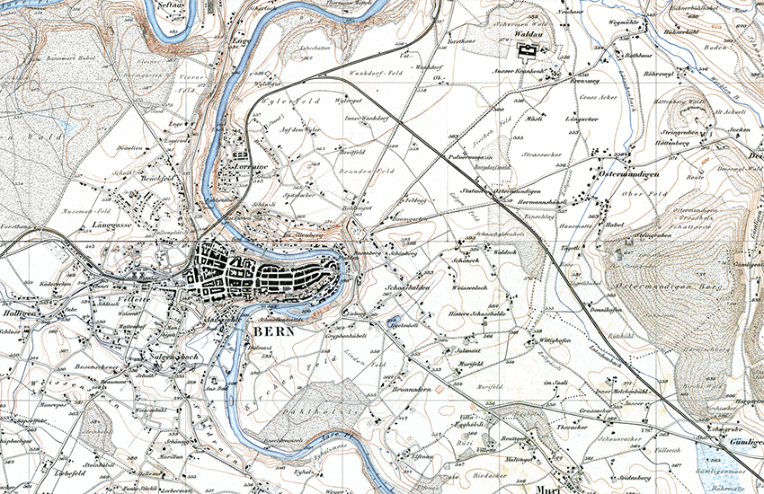
Topographischer Atlas der Schweiz (Siegfriedkarte)
Atlas topographique de la Suisse (Carte Siegfried)
Atlante topografico della Svizzera (Carta Siegfried)
Siegfried Map
Atlas topografic da la Svizra (Charta Siegfried)
In den Jahren 1870 bis 1926 wurde - anfänglich unter der Leitung von Oberst Hermann Siegfried - der Topographische Atlas der Schweiz veröffentlicht. Es handelt sich um das erste detaillierte Gesamtwerk für die Schweiz in den Massstäben 1:25'000 für das Mittelland, den Jura und das Südtessin sowie 1:50'000 für die Alpen. Mit der periodischen Fortführung bis 1949 wurden insgesamt über 4'000 nachgeführte Blätter publiziert. Für die Ersterstellung wurden zwei verschiedene Techniken angewandt: Kupferstich für die 462 Kartenblätter im Massstab 1:25'000 und Steingravur für die 142 Blätter 1:50'000. Sämtliche Ausgaben sind eingescannt worden und stehen nun digital für Untersuchungen zur Landschaftsentwicklung und weitere Anwendungen Verfügung.
L'Atlas topographique de la Suisse a été publié entre 1870 et 1926, initialement sous la direction du colonel Hermann Siegfried. Cest la première carte d'ensemble détaillée de la Suisse à l'échelle 1:25'000 pour le Plateau central, le Jura et le sud du Tessin et, au 1:50'000, pour les Alpes. Au total, si l'on tient compte de la mise à jour périodique effectuée jusqu'en 1949, plus de 4000 feuilles mises à jour ont été publiées. Deux techniques différentes ont été appliquées pour lélaboration initiale: la gravure sur cuivre pour les 462 feuilles à l'échelle 1:25'000 et la lithographie pour les 142 feuilles au 1:50000. Toutes les éditions ont été scannées et sont désormais disponibles sous forme numérique pour des analyses du développement du paysage et d'autres applications.
L’Atlante topografico della Svizzera fu pubblicato tra il 1870 e il 1926. Si tratta della prima serie completa di carte dettagliate della Svizzera in scala 1:25 000 dell’Altopiano, del Giura e del Ticino del Sud, e in scala 1:50 000 delle Alpi. Se si tiene conto dei periodici aggiornamenti fino al 1949, sono state pubblicati in totale più di 4000 fogli aggiornati. Tutte le edizioni sono state scannerizzate e georiferite e sono dunque disponibili in forma digitale per analisi dello sviluppo territoriale o altre applicazioni.
The Topographische Atlas der Schweiz was published over the period from 1870 to 1926, initially under the leadership of Colonel Hermann Siegfried. This was the first complete detailed map series for the whole of Switzerland. It was published at 1:25 000 scale for the lowland areas of the Mittelland, the Jura and south Ticino, and at 1:50 000 scale for alpine regions. With periodic campaigns of revision up to 1949, in all over 4000 revised sheets were published. Two techniques were used for the initial production: copper plate engraving for the 462 sheets at 1:25 000 scale, while the 142 sheets at 1:50 000 were lithographic printed. Every edition has now been scanned and is available in digital form for research into the development of the Swiss landscape and a host of other applications.
Ils onns 1870 fin 1926 è vegnì publitgà – l'emprim sut la direcziun da colonel Hermann Siegfried – l'Atlas topografic da la Svizra. Quai è l'emprima ovra cumpletta detagliada per la Svizra en las scalas 1:25'000 per la Svizra bassa, il Giura ed il Tessin dal sid sco er 1:50'000 per las Alps. Cun la cuntinuaziun periodica fin l'onn 1949 èn vegnids publitgads tut en tut passa 4000 fegls actualisads. Per l'emprima elavuraziun èn vegnidas applitgadas duas differentas tecnicas: la gravura d'arom per ils 462 fegls en la scala 1:25'000 e la gravura da crap per ils 142 fegls 1:50'000. Tut las ediziuns èn vegnidas scannadas e stattan ussa a disposiziun en furma digitala per retschertgas davart il svilup da la cuntrada per ulteriuras applicaziuns.
Simple
-
AlternativtitelAutres appellations ou acronymesTitolo alternativoAlternate titleAlternate title
-
Siegfriedkarte Erstausgabe
Carte Siegfried Première édition
Carta Siegfried Prima edizione
Siegfried Map First edition
Charta Siegfried Emprima ediziun
-
Date (Création)Data (Creazione)Date (Creation)Date (Creation)Datumsangaben (Erstellung)
- 1870-01-01T00:00:00
-
Date (lastRevision)Data (lastRevision)Date (lastRevision)Date (lastRevision)Datumsangaben (lastRevision)
- 1949-01-01T00:00:00
-
IdentificateurIdentificatoreCitation identifierCitation identifierIdentifikator
- ch.swisstopo.hiks-siegfried
Identificateur
Identificatore
Citation identifier
Citation identifier
Identifikator
-
Forme de la présentationFormato di presentazionePresentation formPresentation formPräsentationsform
-
Carte numériqueMappa digitaleDigital mapDigital mapDigitale Karte
-
Forme de la présentationFormato di presentazionePresentation formPresentation formPräsentationsform
-
Carte papierMappa cartaceaHardcopy mapHardcopy mapAnaloge Karte
-
Gemeinsamer TitelTitre collectifTitolo collettivo
-
Historische Karten
Cartes historiques
Carte storiche
-
ZweckButFinalità
-
Georeferenzdaten
Géodonnées de référence
Geodati di riferimento
-
EtatStatusStatusStatusBearbeitungsstatus
-
ArchivéArchivio storicoHistorical archiveHistorical archiveHistorisches Archiv
-
EtatStatusStatusStatusBearbeitungsstatus
-
FinaliséCompletatoCompletedCompletedAbgeschlossen
- Point of contact
-
Organisation name Individual name Electronic mail address Role Bundesamt für Landestopografie swisstopo
Office fédéral de topographie swisstopo
Ufficio federale di topografia swisstopo
Federal Office of Topography swisstopo
Uffizi federal da topografia swisstopo
PropriétaireProprietarioOwnerOwnerEigentümer / DatenherrBundesamt für Landestopografie swisstopo
Office fédéral de topographie swisstopo
Ufficio federale di topografia swisstopo
Federal Office of Topography swisstopo
Uffizi federal da topografia swisstopo
Point de contactPunto di contattoPoint of contactPoint of contactAnsprechpartner
-
Fréquence de mise à jourFrequenza di aggiornamentoMaintenance and update frequencyMaintenance and update frequencyÜberarbeitungsintervall
-
Non planifiéeNon pianificatoNot plannedNot plannedNicht geplant
- Resource format
-
Name Version Tagged Image File Format (TIFF)
-
geocat.ch
-
-
Weg
chemin
cammino
path
-
Landesgrenze
frontière nationale
confine nazionale
national border
-
Höhenkote
cote d'altitude
quota altimetrica
spot height
-
Landeskarte
carte nationale
carta nazionale
national map
-
Einzelsignatur
symbole individuel
simbolo individuale
individual Symbol
-
Fluss
rivière
fiume
river
-
Aufbewahrungs- und Archivierungsplanung AAP - Bund
Planification de la conservation et de l'archivage AAP - Conféderation
Pianificazione della conservazione e dell’archiviazione AAP - Confederazione
Conservation and archiving planning AAP - Confederation
-
Historische Karte
carte historique
carta storica
historic map
-
e-geo.ch
e-geo.ch
e-geo.ch
e-geo.ch
-
GIS (Geografisches Informationssystem)
SIG (Système d'Information Géographique)
SIG (Sistema Informativo Geografico)
GIS (Geographic Information System)
-
Geländedarstellung
représentation du terrain
rappresentazione del terreno
terrain representation
-
Geobasisdaten
géodonnées de base
geodati di base
official geodata
-
Höhenkurve
courbe de niveau
curva di livello
contour line
-
-
GEMET - INSPIRE themes, version 1.0
-
-
Geografische Bezeichnungen
Dénominations géographiques
Nomi geografici
Geographical names
-
Bodenbedeckung
Occupation des terres
Copertura del suolo
Land cover
-
-
GEMET
-
-
Fels
roche
roccia
rock
-
Nomenklatur
nomenclature
nomenclatura
nomenclature
-
Gebiet
province
provincia
province
-
Straße
route
strada
road
-
Gewässer
eaux (géographie)
acque (geografia)
water (geographic)
-
Kartographie
cartographie
cartografia
cartography
-
Bach
ruisseau
ruscello
brook
-
-
geocat.ch
-
-
BGDI Bundesgeodaten-Infrastruktur
IFDG l’Infrastructure Fédérale de données géographiques
IFDG Infrastruttura federale dei dati geografici
FSDI Federal Spatial Data Infrastructure
-
-
GEMET
-
-
Berg
montagne
montagna
mountain
-
-
geocat.ch
-
-
Topografie
topographie
topografia
topography
-
-
GEMET
-
-
Karte
cartogramme
mappa
map chart
-
-
Type de représentation spatialeTipo di rappresentazione spazialeSpatial representation typeSpatial representation typeRäumliche Darstellungsart
-
RasterDati rasterGridGridRaster, Gitter
-
Dénominateur de l'échelleDenominatoreDenominatorDenominatorMaßstabszahl
- 25000
-
Dénominateur de l'échelleDenominatoreDenominatorDenominatorMaßstabszahl
- 50000
-
Langue de la ressourceLingua dei datiLanguageLanguageSprache
- Deutsch
-
Langue de la ressourceLingua dei datiLanguageLanguageSprache
- Français
-
Langue de la ressourceLingua dei datiLanguageLanguageSprache
- Italiano
-
Encodage des caractèresSet dei caratteri dei datiCharacter setCharacter setZeichensatz
-
Utf8UTF8UTF8UTF8Utf8
-
Catégorie ISOTemaTopic categoryTopic categoryISO-Thematik
-
-
Carte de référence de la couverture terrestreMappe di baseImagery base maps earth coverImagery base maps earth coverOberflächenbeschreibung
-
Étendue
Estensione
Extent
Extent
Ausdehnung
-
BeschreibungDescriptionDescrizioneDescription
-
Siegfriedkarte
Carte Siegfried
Carta Siegfried
Siegfried map
))

-
Identifiant géographiqueidentificatore GeograficoGeographic identifierGeographic identifierGeografischer Identifikator
-
TAATATTAnull
-
DimensionsNumero delle dimensioniNumber of dimensionsNumber of dimensionsAnzahl der Dimensionen
- 2
-
Noms des axesNome dimensioneDimension nameDimension nameAchsenbezeichnung
-
Axe - XColonnaColumnColumnSpalte
-
Nombre de pixelMisura dimensioneDimension sizeDimension sizeElementanzahl
- 7000
-
RésolutionRisoluzioneResolutionResolutionAuflösung
- 508 m
-
Noms des axesNome dimensioneDimension nameDimension nameAchsenbezeichnung
-
Axe - YRigaRowRowZeile
-
Nombre de pixelMisura dimensioneDimension sizeDimension sizeElementanzahl
- 4800
-
RésolutionRisoluzioneResolutionResolutionAuflösung
- 508 m
-
Type de rasterGeometria della cellaCell geometryCell geometryZellengeometrie
-
SurfaceAreaAreaAreaFläche
-
Disponibilité des paramètres de transformationDisponibilità dei coefficienti della trasformazioneTransformation parameter availabilityTransformation parameter availabilityVerfügbarkeit von Transformationsparametern
- Distribution format
-
Name Version JPEG (JPG)
Tagged Image File Format (TIFF)
- OnLine resource
-
Protocol Linkage Name MAP:Preview
https://map.geo.admin.ch/?layers=ch.swisstopo.hiks-siegfried Vorschau map.geo.admin.ch
Aperçu map.geo.admin.ch
Previsione map.geo.admin.ch
Preview map.geo.admin.ch
OGC:WMS
https://wms.geo.admin.ch/?SERVICE=WMS&VERSION=1.3.0&REQUEST=GetCapabilities&lang=de ch.swisstopo.hiks-siegfried
ch.swisstopo.hiks-siegfried
ch.swisstopo.hiks-siegfried
ch.swisstopo.hiks-siegfried
ch.swisstopo.hiks-siegfried
OGC:WMTS
https://wmts.geo.admin.ch/EPSG/3857/1.0.0/WMTSCapabilities.xml?lang=de ch.swisstopo.hiks-siegfried
ch.swisstopo.hiks-siegfried
ch.swisstopo.hiks-siegfried
ch.swisstopo.hiks-siegfried
ch.swisstopo.hiks-siegfried
- OnLine resource
-
Protocol Linkage Name WWW:LINK
https://www.swisstopo.admin.ch/de/siegfriedkarte WWW:DOWNLOAD-URL
https://www.swisstopo.admin.ch/de/digitale-siegfriedkarte-1-25000 Shop
CHTOPO:specialised-geoportal
https://map.geo.admin.ch/?noHeader=true&lang=de&X=174500.00&Y=655000.00&zoom=1&topic=swisstopo&bgLayer=ch.swisstopo.pixelkarte-farbe&catalogNodes=1396,1427&layers=ch.swisstopo.hiks-siegfried map.geo.admin.ch
map.geo.admin.ch
map.geo.admin.ch
map.geo.admin.ch
- OnLine resource
-
Protocol Linkage Name ESRI:REST
https://api3.geo.admin.ch/rest/services/api/MapServer/ch.swisstopo.hiks-siegfried RESTful API von geo.admin.ch
RESTful API de geo.admin.ch
RESTful API da geo.admin.ch
RESTful API from geo.admin.ch
RESTful API dad geo.admin.ch
-
NiveauLivelloHierarchy levelHierarchy levelBezugsebene
-
Jeu de donnéesDatasetDatasetDatasetDatenbestand
-
ErläuterungGénéralités sur la provenanceStatement
-
Basiert auf der Siegfriedkarte 1:25'000 und 1:50'000
Se base sur la Carte Siegfried 1:25 000 et 1:50 000
Based on the Siegfried Map 1:25 000 and 1:50 000
Information sur le contenu
Informazioni sul contenuto
Content Information
Content Information
Dateninhalt
Metadata
-
Identifiant de la ficheIdentificatore del file di metadatiFile identifierFile identifierMetadatensatzidentifikator
- d3b21424-70a4-4984-a693-aa7f11813c53 XML
-
LangueLingua dei metadatiMetadata languageMetadata languageSprache
- Deutsch
-
Jeu de caractèresSet dei caratteri dei metadatiCharacter setCharacter setZeichensatz
-
Utf8UTF8UTF8UTF8Utf8
-
Type de ressourceLivello gerarchicoHierarchy levelHierarchy levelHierarchieebene
-
Jeu de donnéesDatasetDatasetDatasetDatenbestand
-
Date des métadonnéesData dei metadatiDate stampDate stampDatum
- 2022-04-04T11:51:04
- Metadata standard name
-
GM03 2+
- Metadata author
-
Organisation name Individual name Electronic mail address Role Bundesamt für Landestopografie swisstopo
Office fédéral de topographie swisstopo
Ufficio federale di topografia swisstopo
Federal Office of Topography swisstopo
Uffizi federal da topografia swisstopo
GestionnaireDepositarioCustodianCustodianVerwalter
- Dataset URI
- Other language
-
Language Character encoding FrançaisFranceseFrenchFrenchFranzösischUtf8UTF8UTF8UTF8Utf8ItalienItalianoItalianItalianItalienischUtf8UTF8UTF8UTF8Utf8AnglaisIngleseEnglishEnglishEnglischUtf8UTF8UTF8UTF8Utf8RomancheRomancioRomanshRomanshRätoromanischUtf8UTF8UTF8UTF8Utf8AllemandTedescoGermanGermanDeutschUtf8UTF8UTF8UTF8Utf8