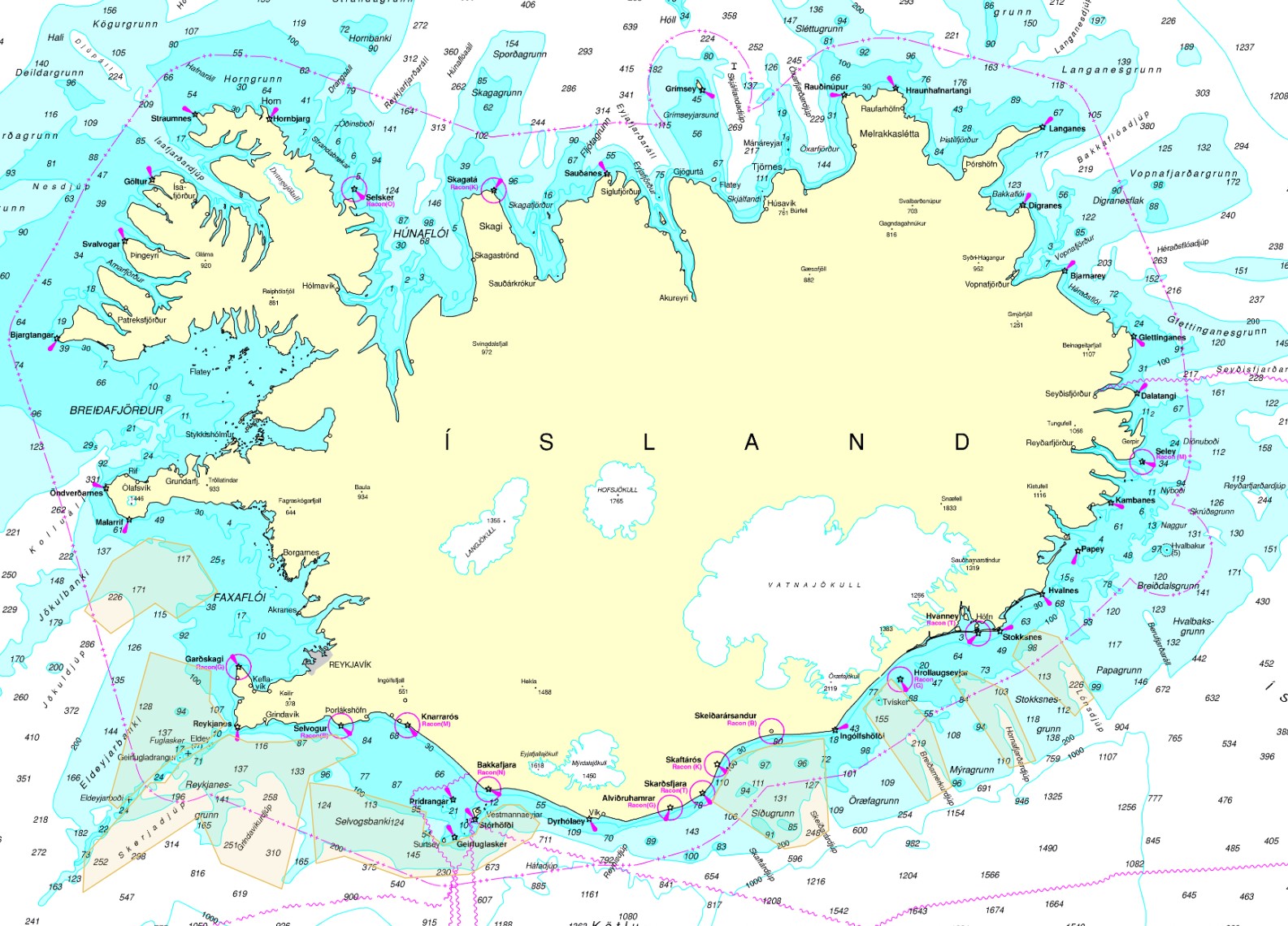
Lokanir á veiðisvæðum
Skyndilokanir
Upplýsingar um skyndilokanir veiðisvæða koma úr gagnagrunnum Fiskistofu. Frá árinu 2020 hefur ákvörðunartaka um skyndilokanir veiðisvæða fyrir tilteknum veiðum verið í höndum Fiskistofu en var áður hjá Hafrannsóknarstofnun. Skyndilokun varir að jafnaði í 2 vikur. Tímamörk lokunar eru alltaf tilgreind með ákvörðun skyndilokunar.
Ákvörðun um skyndilokun veiðisvæðis er gerð þegar mælingar á afla stenst ekki viðmiðunarmörk Hafrannsóknarstofnunar en einnig til að loka svæðum sem hafa staðbundinn kvóta.
Reglugerðalokanir
Reglugerðir eru ákvarðaðar af Atvinnuvega- og nýsköpunarráðuneytinu (ANR) og skilgreina bannsvæði og tímabil, þar sem fiskveiðar eru bannaðar með tilteknum veiðarfærum.
Sumar reglugerðarlokanir eru árstíðarbundnar, til dæmis friðun vegna hrygninga þar sem svæðum sem fiskur kemur til hrygninga er lokað á ákveðnum tíma ársins.
Simple
- Date (Publication)
- 2021-03-26
- Citation identifier
- https://gatt.lmi.is/geonetwork/srv/resourcesd4e86038-bc66-4973-9a31-060b68ace0b8
- Status
- On going
- Point of contact
-
Organisation name Individual name Electronic mail address Role Fiskistofa
Point of contact
- Maintenance and update frequency
- As needed
- Keywords
-
-
veiðisvæði
-
lokanir
-
reglugerð
-
GSL
-
INSPIRE
-
- Use constraints
- Other restrictions
- Other constraints
-
geta þarf heimilda
- Access constraints
- Other restrictions
- Other constraints
- no limitations to public access
- Spatial representation type
- Vector
- Denominator
- 100000
- Language
- English
- Character set
- UTF8
- Topic category
-
- Oceans
))
- Reference system identifier
- http://www.opengis.net/def/crs/EPSG/0/5325
- Distribution format
-
Name Version ESRI Shapefile
10.5.0.6491
- OnLine resource
-
Protocol Linkage Name OGC:WMS
https://gis.is/geoserver/fiskistofa/wms?request=getcapabilities fiskistofa:virk_annad
OGC:WMS
https://gis.is/geoserver/fiskistofa/wms?request=getcapabilities fiskistofa:virk_grasleppulokanir
OGC:WMS
https://gis.is/geoserver/fiskistofa/wms?request=getcapabilities fiskistofa:virk_hrygningarsvaedi
OGC:WMS
https://gis.is/geoserver/fiskistofa/wms?request=getcapabilities fiskistofa:virkar_reglugerðir
OGC:WMS
https://gis.is/geoserver/fiskistofa/wms?request=getcapabilities fiskistofa:virkar_skyndilokanir
OGC:WFS-1.0.0-http-get-capabilities
https://gis.is/geoserver/fiskistofa/wfs?request=getcapabilities fiskistofa:virk_annad
OGC:WFS-1.0.0-http-get-capabilities
https://gis.is/geoserver/fiskistofa/wfs?request=getcapabilities fiskistofa:virk_grasleppulokanir
OGC:WFS-1.0.0-http-get-capabilities
https://gis.is/geoserver/fiskistofa/wfs?request=getcapabilities fiskistofa:virk_hrygningarsvaedi
OGC:WFS-1.0.0-http-get-capabilities
https://gis.is/geoserver/fiskistofa/wfs?request=getcapabilities fiskistofa:virkar_reglugerðir
OGC:WFS-1.0.0-http-get-capabilities
https://gis.is/geoserver/fiskistofa/wfs?request=getcapabilities fiskistofa:virkar_skyndilokanir
WWW:LINK-1.0-http--link
https://atlas.lmi.is/mapview/?application=haf Hafsjá
WWW:LINK-1.0-http--link
https://island.is/reglugerdir/nr/0837-2020 Reglugerð um tímabundið bann við veiðum á tveimur svæðum í Jökuldýpi.
WWW:LINK-1.0-http--link
https://island.is/reglugerdir/nr/1080-2019 Reglugerð um bann við veiðum á sæbjúgum á veiðisvæði út af Austurlandi, suðursvæði.
WWW:LINK-1.0-http--link
https://island.is/reglugerdir/nr/0520-2020 Reglugerð um bann við veiðum á ígulkerum í Breiðafirði, norðursvæði.
WWW:LINK-1.0-http--link
https://island.is/reglugerdir/nr/0742-2021 Reglugerð um tímabundið bann við veiðum með fiskibotnvörpu út af Glettinganesi.
WWW:LINK-1.0-http--link
https://island.is/reglugerdir/nr/1459-2022 Reglugerð um tímabundið bann við veiðum með fiskibotnvörpu á Berufjarðarálshorni.
WWW:LINK-1.0-http--link
https://island.is/reglugerdir/nr/0890-2020 Reglugerð um veiðisvæði hörpudisks.
WWW:LINK-1.0-http--link
https://island.is/reglugerdir/nr/0186-2020 Reglugerð um tímabundið bann við veiðum með fiskibotnvörpu á veiðisvæðum humars.
WWW:LINK-1.0-http--link
https://island.is/reglugerdir/nr/0958-2019 Reglugerð um friðun þorsks, skarkola, blálöngu og steinbíts á hrygningartíma.
- Hierarchy level
- Dataset
Conformance result
- Date (Publication)
- 2010-12-08
- Explanation
-
Validation has not been performed.
- Pass
- No
- Statement
-
Vinsamlega hafið samband við Fiskistofu vegna nánari upplýsinga
Metadata
- File identifier
- d4e86038-bc66-4973-9a31-060b68ace0b8 XML
- Metadata language
- English
- Character set
- UTF8
- Hierarchy level
- Dataset
- Date stamp
- 2023-02-13T14:43:09
- Metadata standard name
-
INSPIRE Metadata Implementing Rules
- Metadata standard version
-
Technical Guidelines based on EN ISO 19115 and EN ISO 19119 (Version 1.2)
- Metadata author
-
Organisation name Individual name Electronic mail address Role Fiskistofa
Point of contact
Overviews

Spatial extent
))
Provided by

 INSPIRE Geoportal