 INSPIRE Geoportal
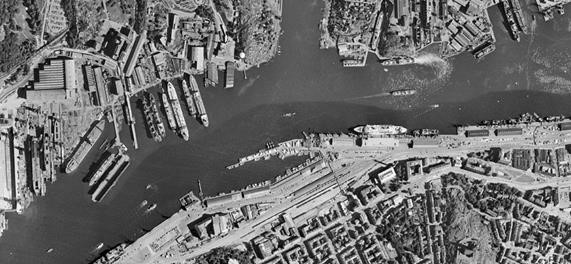
Ortofoto historiska Visning
Visningstjänst för Historiska ortofoton i svartvitt med 0,5 m upplösning. Med våra visningstjänster kan du använda Lantmäteriets skalriktiga flygbilder, så kallade ortofoton, i dina egna system eller applikationer. Visningstjänsterna går att kombinera med våra övriga geodatatjänster. Tjänsten uppfyller kraven för EU-direktivet Inspire.
Historiska ortofoton finns tillgängliga i flera lager:
* Ett komplett rikstäckande lager för referensåret 1960, som innehåller svartvita ortofoton från åren 1949 till 1970, med upplösning 0,5 m.
* Ett lager för referensår 1975, som täcker stora delar av Sverige, vilket huvudsakligen innehåller svartvita ortofoton från åren 1970 till 1980, med upplösning 0,5 m.
*Separata årslager fr.o.m. 1993 t.o.m. 2005, som innehåller svartvita ortofoton med upplösning 1 m, samt ortofoton i färg (endast 2002-2005) och ir (endast 2003-2005) med upplösning 0,5 m.
För ortofotona i referensårslagren 1960 och 1975 redovisas även utbredning och flygfotoår för varje ortofoto i egna metadatalager, även sömlinjer och BildId för ingående flygbilder redovisas i separata metadatalager. För årslagren 1993-2005 finns dock inga metadata alls tillgängliga.
Simple
Identification info
- Alternate title
-
Historical orthophoto View Service
- Date (Publication)
- 2018-03-20
- Date (Revision)
- 2022-03-30
- Point of contact
-
Organisation name Individual name Electronic mail address Role Lantmäteriet
Geodatasupport
Owner
- Maintenance and update frequency
- Continual
- Maintenance note
-
Tjänsten uppdateras kontinuerligt med historiska ortofoton allt eftersom de framställs.
-
KOMMISSIONENS FÖRORDNING (EG) nr 1205/2008 av den 3 december 2008 om genomförande av Europaparlamentets och rådets direktiv 2007/2/EG om metadata
- Initiativ
-
-
Öppna data
-
Inspire
-
Resource constraints
- Access constraints
- Other restrictions
- Other constraints
- Inga begränsningar för allmänhetens tillgång
- Access constraints
- Other restrictions
- Other constraints
- Ingen begränsning
- Use constraints
- Other restrictions
- Other constraints
- Historiska ortofoton tillhandahålls utan licensavgift och med förenklade användningsvillkor. Produkten tillhör Lantmäteriets öppna data.
- Service Type
- view
- Description
-
Hela Sverige
))
- Coupled Resource
-
Operation Name Scoped name Identifier GetCapabilities
undefined c4c38adc-1e35-4054-a2f5-d6e77a95bd3c
Contains Operations
- Reference system identifier
- http://www.opengis.net/def/crs/EPSG/0/4326
- Reference system identifier
- http://www.opengis.net/def/crs/EPSG/0/3035
- Reference system identifier
- http://www.opengis.net/def/crs/EPSG/0/3034
- Reference system identifier
- http://www.opengis.net/def/crs/EPSG/0/3044
- Reference system identifier
- http://www.opengis.net/def/crs/EPSG/0/3045
- Reference system identifier
- http://www.opengis.net/def/crs/EPSG/0/3857
- Reference system identifier
- http://www.opengis.net/def/crs/EPSG/0/3007
- Reference system identifier
- http://www.opengis.net/def/crs/EPSG/0/3006
- Reference system identifier
- http://www.opengis.net/def/crs/EPSG/0/4258
- Reference system identifier
- http://www.opengis.net/def/crs/EPSG/0/4619
- Reference system identifier
- http://www.opengis.net/def/crs/EPSG/0/3035
- Reference system identifier
- http://www.opengis.net/def/crs/EPSG/0/3046
- Reference system identifier
- http://www.opengis.net/def/crs/EPSG/0/3047
- Reference system identifier
- http://www.opengis.net/def/crs/EPSG/0/3021
- Reference system identifier
- http://www.opengis.net/def/crs/EPSG/0/3010
- Reference system identifier
- http://www.opengis.net/def/crs/EPSG/0/3014
- Reference system identifier
- http://www.opengis.net/def/crs/EPSG/0/3011
- Reference system identifier
- http://www.opengis.net/def/crs/EPSG/0/3015
- Reference system identifier
- http://www.opengis.net/def/crs/EPSG/0/3016
- Reference system identifier
- http://www.opengis.net/def/crs/EPSG/0/3017
- Reference system identifier
- http://www.opengis.net/def/crs/EPSG/0/3018
- Reference system identifier
- http://www.opengis.net/def/crs/EPSG/0/25832
- Reference system identifier
- http://www.opengis.net/def/crs/EPSG/0/25833
- Reference system identifier
- http://www.opengis.net/def/crs/EPSG/0/25834
- Reference system identifier
- http://www.opengis.net/def/crs/EPSG/0/25835
- Reference system identifier
- http://www.opengis.net/def/crs/EPSG/0/32632
- Reference system identifier
- http://www.opengis.net/def/crs/EPSG/0/32633
- Reference system identifier
- http://www.opengis.net/def/crs/EPSG/0/32634
- Reference system identifier
- http://www.opengis.net/def/crs/EPSG/0/32635
Distributor
- Distributor contact
-
Organisation name Individual name Electronic mail address Role Lantmäteriet
Geodatasupport
Distributor
- OnLine resource
-
Protocol Linkage Name HTTP:Information
https://www.lantmateriet.se/sv/Kartor-och-geografisk-information/geodataprodukter/produktlista/ortofoto-historiska-visning/ Lantmäteriets webbplats
HTTP:OGC:WMS
https://maps.lantmateriet.se/capabilities/api/historiska-ortofoton/wms/v1?request=getcapabilities&version=1.1.1 Åtkomstpunkt öppen capabilityfil
HTTP:OGC:WMS
https://api.lantmateriet.se/historiska-ortofoton/wms/v1?request=GetCapabilities&version=1.1.1&service=WMS Åtkomstpunkt till Historiska ortofoton Visning
- Hierarchy level
- Service
- Other
-
Tjänst
Conformance result
- Date (Publication)
- 2009-10-20
- Explanation
-
Enligt ovanstående specifikation
- Pass
- Yes
Metadata
- File identifier
- e04a0e7c-2c86-4931-a6f5-bab4091c8745 XML
- Metadata language
- Swedish
- Hierarchy level
- Service
- Hierarchy level name
-
Tjänst
- Date stamp
- 2024-04-17T10:13:46
- Metadata standard name
-
SS-EN-ISO-19115:2005-NMDP 4.0
- Metadata standard version
-
4.0
- Metadata author
-
Organisation name Individual name Electronic mail address Role Lantmäteriet
Geodatasupport
Point of contact
Overviews
Spatial extent
Provided by
