INSPIRE Geoportal
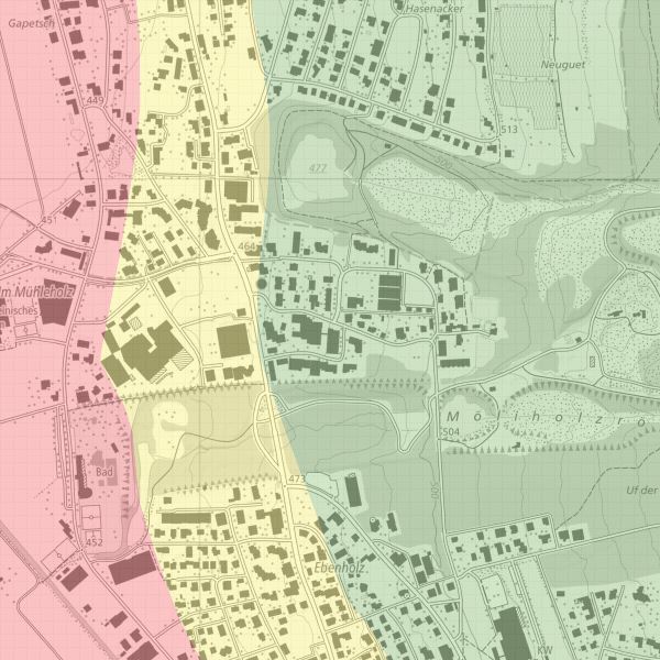
Erdsondenkarte
Die Erdsondenkarte zeigt, wo Erdsonden bewilligungsfähig sind. Die Abgrenzung "bewilligungsfähig/nicht bewilligungsfähig" ist im Grenzbereich auf ca. +- 20 m festgelegt.
Simple
-
Date (Publication)Data (Pubblicazione)Date (Publication)Datumsangaben (Publikation)
- 2006-05-09
-
IdentificateurIdentificatoreCitation identifierIdentifikator
- https://metadata.geo.llv.li/ea1a780b-f752-41f6-917d-8f424eb4aae5
-
Zweck
-
Vorinformation, allgemeine Angaben
-
EtatStatusStatusBearbeitungsstatus
-
FinaliséCompletatoCompletedAbgeschlossen
- Point of contact
-
Organisation name Individual name Electronic mail address Role Amt für Umwelt (LI)
Office de l'environnement
Amt für Umwelt
Amt für Umwelt
Point de contactPunto di contattoPoint of contactAnsprechpartner
-
Fréquence de mise à jourFrequenza di aggiornamentoMaintenance and update frequencyÜberarbeitungsintervall
-
Lorsque nécessaireSecondo necessitàAs neededBei Bedarf
- Resource format
-
Name Version INTERLIS 1 (ITF)
-
geocat.ch
-
-
INSPIRE
INSPIRE
INSPIRE
INSPIRE
-
-
GEMET - INSPIRE themes, version 1.0
-
-
Energiequellen
Sources d'énergie
Risorse energetiche
Energy resources
-
-
Spatial scope
-
-
National
Nationales
Nazionali
National
-
-
GEMET
-
-
Erdwärme
énergie géothermique
energia geotermica
geothermal energy
-
-
Contraintes d'accèsVincoli di accessoAccess constraintsZugriffseinschränkungen
-
Autres restrictionsAltri vincoliOther restrictionsBenutzerdefinierte Einschränkungen
-
Andere Einschränkungen
-
no limitations to public access
-
Anwendungseinschränkungen
-
Zugangs- und Nutzungsbedingungen
-
Contraintes d'utilisationVincoli di fruibilitàUse constraintsNutzungseinschränkungen
-
Autres restrictionsAltri vincoliOther restrictionsBenutzerdefinierte Einschränkungen
-
Andere Einschränkungen
-
gebührenpflichtig
-
Type de représentation spatialeTipo di rappresentazione spazialeSpatial representation typeRäumliche Darstellungsart
-
VecteurDati vettorialiVectorVektor
-
Dénominateur de l'échelleDenominatoreDenominatorMassstabszahl
- 5000
-
Langue de la ressourceLingua dei datiLanguageSprache
- Deutsch
-
Encodage des caractèresSet dei caratteri dei datiCharacter setZeichensatz
-
Utf8UTF8UTF8Utf8
-
Catégorie ISOTemaTopic categoryThematik
-
-
Sciences de la terre, géosciencesInformazioni geoscientificheGeoscientific informationGeowissenschaften
-
Constructions et ouvragesStruttureStructureBauwerke
-
Étendue
Estensione
Extent
Ausdehnung
-
BeschreibungDescriptionDescrizioneDescription
-
Liechtenstein
Liechtenstein
Liechtenstein
Liechtenstein
))

-
Nom du système de référenceIdentificatore del sistema di riferimentoReference system identifierIdentifikator des Referenzsystems
-
http://www.opengis.net/def/crs/EPSG/0/2056
-
Nom du système de référenceIdentificatore del sistema di riferimentoReference system identifierIdentifikator des Referenzsystems
-
http://www.opengis.net/def/crs/EPSG/0/4936
-
Niveau topologieLivello di topologiaTopology levelTopologielevel
-
Topologie de réseau complèteGrafo planare completoFull planar graphFlächen
-
Type de géométries des objetsOggetto di tipo geometricoGeometric object typeGeometrietyp
-
PolygoneSuperficieSurfaceFläche
-
Nombre d'objets géométriquesConteggio oggetto geometricoGeometric object countAnzahl
- 30
- Distribution format
-
Name Version INTERLIS 1 (ITF)
ESRI Shapefile (SHP)
- Distributor contact
-
Organisation name Individual name Electronic mail address Role Abt. Vermessung und Geoinformation (ATG)
Abt. Vermessung und Geoinformation (ATG)
Abt. Vermessung und Geoinformation (ATG)
Abt. Vermessung und Geoinformation (ATG)
Point de contactPunto di contattoPoint of contactAnsprechpartner
- OnLine resource
-
Protocol Linkage Name WWW:LINK
https://www.llv.li/inhalt/12562/amtsstellen/geodatenportal
-
NiveauLivelloHierarchy levelBezugsebene
-
Jeu de donnéesDatasetDatasetDatenbestand
Résultat de conformité
Conformità
Conformance result
Konformitätsergebnis
-
Date (Publication)Data (Pubblicazione)Date (Publication)Datumsangaben (Publikation)
- 2010-12-08
- Explanation
-
Gemäss INSPIRE Bestandteil des Themas "Bewirtschaftungsgebiete/Schutzgebiete/geregelte Gebiete und Berichterstattungseinheiten"
-
Degré de conformitéPassPassBestanden
- No
-
Erläuterung
-
Digitalisierung
-
LangueLinguaLanguageSprache
- Deutsch
-
Inclus dans le jeu de donnéesIncluded with datasetIncluded with datasetIm Datenbestand enthalten
-
Date (Publication)Data (Pubblicazione)Date (Publication)Datumsangaben (Publikation)
- 2008-05-19
Metadata
-
Identifiant de la ficheIdentificatore del file di metadatiFile identifierMetadatensatzidentifikator
- ea1a780b-f752-41f6-917d-8f424eb4aae5 XML
-
LangueLingua dei metadatiMetadata languageSprache
- Deutsch
-
Jeu de caractèresSet dei caratteri dei metadatiCharacter setZeichensatz
-
Utf8UTF8UTF8Utf8
-
Type de ressourceLivello gerarchicoHierarchy levelHierarchieebene
-
Jeu de donnéesDatasetDatasetDatenbestand
-
Date des métadonnéesData dei metadatiDate stampDatum
- 2023-03-07T10:31:51.794Z
- Metadata standard name
-
GM03 2+
- Metadata author
-
Organisation name Individual name Electronic mail address Role Amt für Umwelt (LI)
Office de l'environnement
Amt für Umwelt
Amt für Umwelt
Point de contactPunto di contattoPoint of contactAnsprechpartner
- Dataset URI
- Other language
-
Language Character encoding FrançaisFranceseFrenchFranzösischUtf8UTF8UTF8Utf8ItalienItalianoItalianItalienischUtf8UTF8UTF8Utf8AnglaisIngleseEnglishEnglischUtf8UTF8UTF8Utf8AllemandTedescoGermanDeutschUtf8UTF8UTF8Utf8