 INSPIRE Geoportal
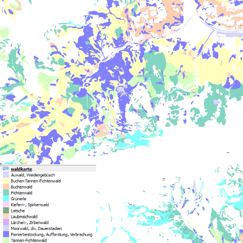
Darstellungsdienst Waldkarte Vorarlberg
Darstellungsdienst zur Kartierung der potentiell natürlichen Waldgesellschaften auf Grundlage der pflanzensoziologischen Methodik.
Die Attributtabelle weist folgende Felder (mit Definition) auf:
waldcode (double)
name (sting)
beschreibu (string)
deutsch (string),
Ist für INSPIRE gemeldet.
Simple
Identification info
- Date (Creation)
- 2014-10-17
- Date (Revision)
- 2019-07-08T12:00:00
- Point of contact
-
Organisation name Individual name Electronic mail address Role Vorarlberg, Landesamt für Vermessung und Geoinformation, Abteilung Geoinformation
Publisher Vorarlberg, Landesamt für Vermessung und Geoinformation, Abteilung Geoinformation
Custodian
- Keywords
-
-
humanGeographicViewer
-
Waldkarte
-
-
GEMET - INSPIRE themes, version 1.0
-
-
Bewirtschaftungsgebiete/Schutzgebiete/geregelte Gebiete und Berichterstattungseinheiten
-
-
GEMET - Concepts, version 3.1
-
-
Nadelwald
-
Laubwald
-
Waldökologie
-
Wald
-
Ökosystem
-
Waldwirtschaft
-
- Access constraints
- Other restrictions
- Use constraints
- Other restrictions
- Other constraints
- Namensnennung 4.0 International (CC BY 4.0)
- Other constraints
-
(c) Land Vorarlberg
- Service Type
- view
))
- Coupled Resource
-
Operation Name Scoped name Identifier GetCapabilities
undefined 7d4579eb-027e-40e1-8f22-c23072a0ed7e
Contains Operations
- Reference system identifier
- EPSG / http://www.opengis.net/def/crs/EPSG/0/31254 / 8.6
- Reference system identifier
- EPSG / http://www.opengis.net/def/crs/EPSG/0/3035 /
- Reference system identifier
- EPSG / http://www.opengis.net/def/crs/EPSG/0/4326 /
- OnLine resource
-
Protocol Linkage Name OGC:WMS-http-get-capabilities
http://vogis.cnv.at/inspire-download/waldkarte_epsg_3035_uuid_7d4579eb-027e-40e1-8f22-c23072a0ed7e_getcapabilities.xml INSPIRE-Darstellungsdienst
- Hierarchy level
- Service
- Other
-
Service
Domain consistency
Conformance result
- Date (Publication)
- 2009-10-20
- Explanation
-
siehe Referenzdokument (INSPIRE Technical Guidelines)
- Pass
- Yes
Metadata
- File identifier
- ecf7fbad-baf6-4aee-905d-9771790f9c0f XML
- Metadata language
- Deutsch
- Hierarchy level
- Service
- Hierarchy level name
-
Dienst
- Date stamp
- 2023-11-24T09:43:12
- Metadata standard name
-
ISO19119
- Metadata standard version
-
2005/PDAM 1
- Metadata author
-
Organisation name Individual name Electronic mail address Role Vorarlberg, Landesamt für Vermessung und Geoinformation, Abteilung Geoinformation
Point of contact
Overviews
Spatial extent
Provided by
