INSPIRE Geoportal
Sicherheitszonenplan
Plan de la zone de sécurité
Piano delle zone di sicurezza
Safety zone plan
Plan da zonas da segirezza
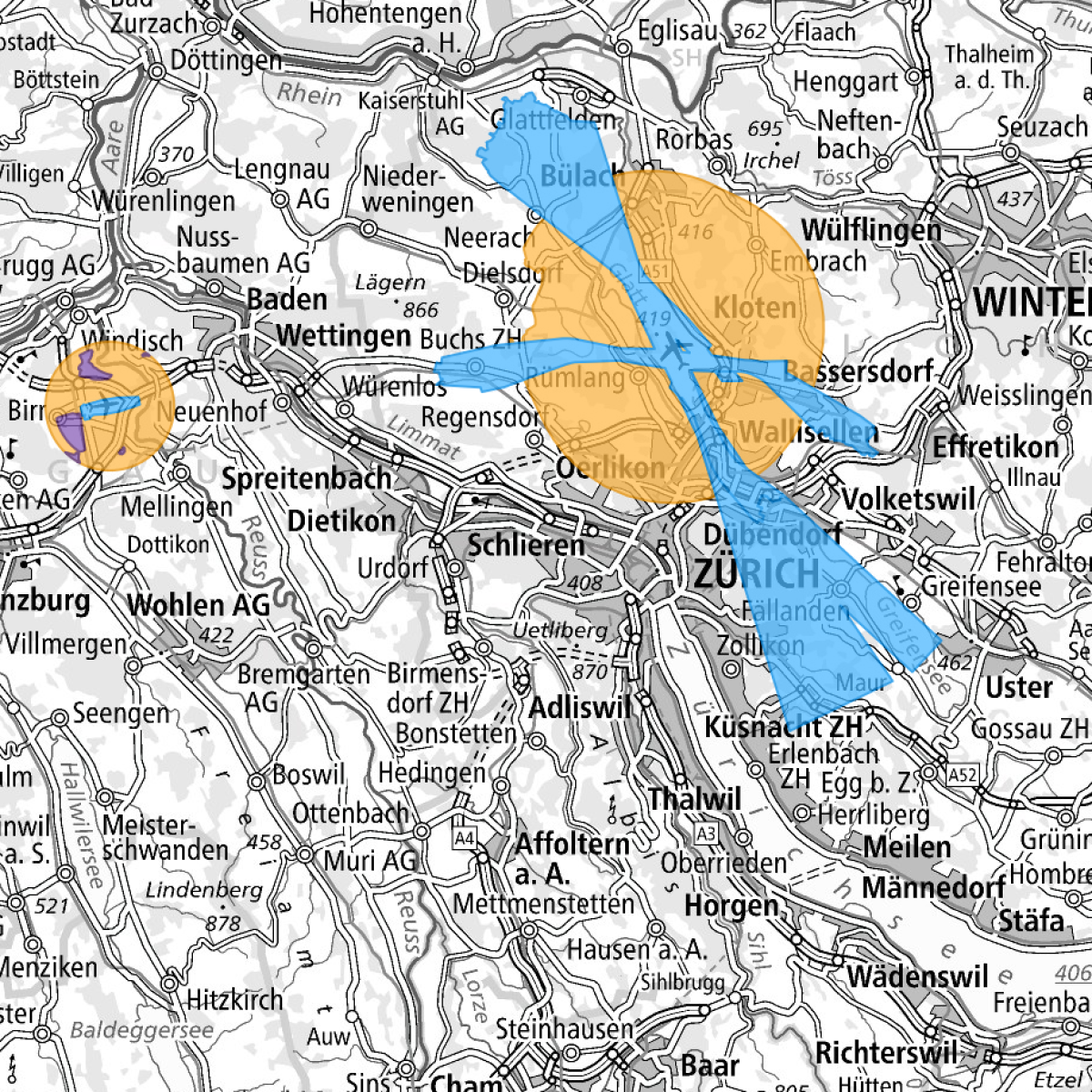
Für jeden Flughafen ist eine Sicherheitszone zu errichten, welche den Luftraum vor Hindernissen schützt. Das BAZL entscheidet im Einzelfall, ob für Flugsicherungsanlagen und Flugwege eine Sicherheitszone erforderlich ist. Für die Festsetzung der Sicherheitszonen sind die Hindernisbegrenzungsflächen-Kataster massgebend. Die Sicherheitszone wird in einem Zonenplan dargestellt, aus dem die Eigentumsbeschränkungen nach Fläche und Höhe ersichtlich sind. Die genehmigten Sicherheitszonenpläne werden mit ihrer Veröffentlichung in den kantonalen Publikationsorganen verbindlich und stellen eine öffentlich-rechtliche Eigentumsbeschränkung dar.
Une zone de sécurité doit être établie pour chaque aéroport. Pour les installations de navigation aérienne et les trajectoires de vol, l’OFAC décide dans chaque cas si une zone de sécurité est nécessaire. Le cadastre des surfaces de limitation d’obstacles est déterminant pour établir les zones de sécurité. Elles sont représentées dans un plan de zone indiquant les restrictions de la propriété en surface et en hauteur. Le plan des zones de sécurité approuvé entre en force par sa publication dans les organes officiels cantonaux et constitue une restriction de droit public apportée à la propriété foncière.
Per ogni aeroporto deve essere fissata una zona di sicurezza volta a proteggere lo spazio aereo da ostacoli. L’UFAC decide caso per caso se è necessario fissare una zona di sicurezza per gli impianti della navigazione aerea e le traiettorie di volo. Per la delimitazione delle zone di sicurezza è determinante il catasto delle superfici di limitazione degli ostacoli. La zona di sicurezza è illustrata in un piano di zona che indica le restrizioni della proprietà in superficie e in altezza. I piani delle zone di sicurezza approvati diventano vincolanti con la pubblicazione negli organi cantonali ufficiali e rappresentano una restrizione di diritto pubblico della proprietà.
For each airport, a security zone is to be established, which protects the airspace from obstacles. The FOCA will decide in each case whether a safety zone is necessary for air navigation equipment and flight paths. Authoritative for the establishment of safety zones is the cadastre of obstacle limitation surfaces. The safety zones are represented in a zone map, where the location and height of property restrictions are shown. The approved security zone plans are binding upon publication in the cantonal publications and constitute a public property restriction.
Per mintga eroport sto vegnir endrizzada ina zona da segirezza che protegia il spazi d'aria cunter obstachels. Il UFAC decida en il cas singul, sch'i dovra ina zona da segirezza per ils implants da controlla dal traffic aviatic e per las vias da sgol. Per fixar las zonas da segirezza èn decisivs ils catasters da las surfatschas da cunfinaziun dals obstachels. La zona da segirezza vegn preschentada en in plan da zonas che mussa las restricziuns da la proprietad tenor surfatscha e tenor autezza. Suenter ch'ils plans da zonas da segirezza èn vegnids approvads, daventan els liants cur ch'els vegnan publitgads en ils organs da publicaziun chantunals. Els constitueschan ina restricziun da la proprietad dal dretg public.
Simple
-
AlternativtitelAutres appellations ou acronymesTitolo alternativoAlternate titleAlternate title
-
Sicherheitszonenplan
Plan de la zone de sécurité
Piano delle zone di sicurezza
Safety zone plan
Plan da zonas da segirezza
-
Date (Création)Data (Creazione)Date (Creation)Date (Creation)Datumsangaben (Erstellung)
- 2013-11-18
-
Date (Publication)Data (Pubblicazione)Date (Publication)Date (Publication)Datumsangaben (Publikation)
- 2023-08-15
-
IdentificateurIdentificatoreCitation identifierCitation identifierIdentifikator
- ch.bazl.sicherheitszonenplan
Identificateur
Identificatore
Citation identifier
Citation identifier
Identifikator
-
Gemeinsamer TitelTitre collectifTitolo collettivo
-
Sicherheitszonenplan
Plan de la zone de sécurité
Piano delle zone di sicurezza
-
ZweckButFinalità
-
Geobasisdaten des Bundesrechts
Géodonnées de base relevant du droit fédéral
Geodati di base del diritto federale
-
EtatStatusStatusStatusBearbeitungsstatus
-
Mise à jour continueIn corsoOn goingOn goingKontinuierliche Aktualisierung
- Point of contact
-
Organisation name Individual name Electronic mail address Role Bundesamt für Zivilluftfahrt
Office fédéral de aviation civile
Ufficio federale dell’aviazione civile
Federal Office of Civil Aviation
Bundesamt für Zivilluftfahrt
adrian.nuetzi@bazl.adm adrian.nuetzi@bazl.admin.ch
Point de contactPunto di contattoPoint of contactPoint of contactAnsprechpartnerBundesamt für Zivilluftfahrt
Office fédéral de aviation civile
Ufficio federale dell'aviazione civile
Federal Office of Civil Aviation
Bundesamt für Zivilluftfahrt
info@bazl.adm info@bazl.admin.ch
PropriétaireProprietarioOwnerOwnerEigentümer / Datenherr
-
Fréquence de mise à jourFrequenza di aggiornamentoMaintenance and update frequencyMaintenance and update frequencyÜberarbeitungsintervall
-
Lorsque nécessaireSecondo necessitàAs neededAs neededBei Bedarf
-
geocat.ch
-
-
opendata.swiss
opendata.swiss
opendata.swiss
opendata.swiss
opendata.swiss
-
Aufbewahrungs- und Archivierungsplanung AAP - Bund
Planification de la conservation et de l'archivage AAP - Conféderation
Pianificazione della conservazione e dell’archiviazione AAP - Confederazione
Conservation and archiving planning AAP - Confederation
-
Zonenplan
plan de zones
piano delle zone
zoning plan
-
Geobasisdaten
géodonnées de base
geodati di base
official geodata
-
Luftfahrt
navigation aérienne
navigazione aerea
air navigation
-
Luftfahrthindernis
obstacle à la navigation aérienne
ostacolo alla navigazione aerea
air navigation obstacle
-
Flugplatz
aérodrome
aerodromo
airfield
-
-
GEMET
-
-
Flughafen
aéroport
aeroporto
airport
-
Zivilluftverkehr
navigation aérienne civile
traffico aereo civile
civil air traffic
-
Sicherheit
sécurité
sicurezza
safety
-
Luftverkehr
trafic aérien
traffico aereo
air traffic
-
-
geocat.ch
-
-
BGDI Bundesgeodaten-Infrastruktur
IFDG l’Infrastructure Fédérale de données géographiques
IFDG Infrastruttura federale dei dati geografici
FSDI Federal Spatial Data Infrastructure
-
-
Contraintes d'utilisationVincoli di fruibilitàUse constraintsUse constraintsNutzungseinschränkungen
-
Autres restrictionsAltri vincoliOther restrictionsOther restrictionsBenutzerdefinierte Einschränkungen
-
Andere EinschränkungenAutres contraintesAltri vincoliOther constraints
-
Opendata BY: Freie Nutzung. Quellenangabe ist Pflicht.Opendata BY: Utilisation libre. Obligation d’indiquer la source.Opendata BY: Libero utilizzo. Indicazione della fonte obbligatoria.Opendata BY: Open use. Must provide the source.
-
Andere EinschränkungenAutres contraintesAltri vincoliOther constraintsOther constraints
-
Type de représentation spatialeTipo di rappresentazione spazialeSpatial representation typeSpatial representation typeRäumliche Darstellungsart
-
VecteurDati vettorialiVectorVectorVektor
-
Dénominateur de l'échelleDenominatoreDenominatorDenominatorMassstabszahl
- 1000
-
Dénominateur de l'échelleDenominatoreDenominatorDenominatorMassstabszahl
- 100000
-
Langue de la ressourceLingua dei datiLanguageLanguageSprache
- Deutsch
-
Langue de la ressourceLingua dei datiLanguageLanguageSprache
- Français
-
Langue de la ressourceLingua dei datiLanguageLanguageSprache
- Italiano
-
Encodage des caractèresSet dei caratteri dei datiCharacter setCharacter setZeichensatz
-
Utf8UTF8UTF8UTF8Utf8
-
Catégorie ISOTemaTopic categoryTopic categoryThematik
-
-
Cadastre, aménagementPianificazione del territorio e catastoPlanning cadastrePlanning cadastrePlanungsunterlagen, Kataster
-
Étendue
Estensione
Extent
Extent
Ausdehnung
-
BeschreibungDescriptionDescrizioneDescriptionDescription
-
Schweiz
Suisse
Svizzera
Switzerland
Svizra
))

-
Nom du système de référenceIdentificatore del sistema di riferimentoReference system identifierReference system identifierIdentifikator des Referenzsystems
-
EPSG: 2056EPSG: 2056EPSG: 2056EPSG: 2056EPSG: 2056
-
Type de géométries des objetsOggetto di tipo geometricoGeometric object typeGeometric object typeGeometrietyp
-
PolygoneSuperficieSurfaceSurfaceFläche
- Distribution format
-
Name Version INTERLIS
2
andere Formate auf Anfrage
-
Geopackage (ogc)
-
- OnLine resource
-
Protocol Linkage Name MAP:Preview
https://map.geo.admin.ch/?layers=ch.bazl.sicherheitszonenplan Vorschau map.geo.admin.ch
Aperçu map.geo.admin.ch
Previsione map.geo.admin.ch
Preview map.geo.admin.ch
- OnLine resource
-
Protocol Linkage Name WWW:LINK
https://www.bazl.admin.ch/bazl/de/home/themen/geoinformation_statistik/geoinformation/geobasisdaten/sicherheitszonenplan--geoiv-id-108-.html
- OnLine resource
Metadata
-
Identifiant de la ficheIdentificatore del file di metadatiFile identifierFile identifierMetadatensatzidentifikator
- f0ac2ddb-8b07-421b-ada6-8c192b593bca XML
-
LangueLingua dei metadatiMetadata languageMetadata languageSprache
- Deutsch
-
Jeu de caractèresSet dei caratteri dei metadatiCharacter setCharacter setZeichensatz
-
Utf8UTF8UTF8UTF8Utf8
-
Type de ressourceLivello gerarchicoHierarchy levelHierarchy levelHierarchieebene
-
Jeu de donnéesDatasetDatasetDatasetDatenbestand
-
Date des métadonnéesData dei metadatiDate stampDate stampDatum
- 2023-10-26T06:49:45.74Z
- Metadata standard name
-
GM03 2+
- Metadata author
-
Organisation name Individual name Electronic mail address Role Bundesamt für Zivilluftfahrt
Office fédéral de aviation civile
Ufficio federale dell'aviazione civile
Federal Office of Civil Aviation
Bundesamt für Zivilluftfahrt
gis@bazl.adm gis@bazl.admin.ch
Point de contactPunto di contattoPoint of contactPoint of contactAnsprechpartner
- Other language
-
Language Character encoding FrançaisFranceseFrenchFrenchFranzösischUtf8UTF8UTF8UTF8Utf8ItalienItalianoItalianItalianItalienischUtf8UTF8UTF8UTF8Utf8AnglaisIngleseEnglishEnglishEnglischUtf8UTF8UTF8UTF8Utf8RomancheRomancioRomanshRomanshRätoromanischUtf8UTF8UTF8UTF8Utf8AllemandTedescoGermanGermanDeutschUtf8UTF8UTF8UTF8Utf8