INSPIRE Geoportal
Hydrogeologische Karte der Schweiz: Grundwasservorkommen 1:500000
Carte hydrogéologique de la Suisse : Réservoirs aquifères 1:500000
Carta idrogeologica della Svizzera: riserve acquifere 1:500000
Hydrogeological Map of Switzerland: Groundwater Resources 1:500000
Charta idrogeologica da la Svizra: resursas d'aua sutterrana 1:500'000
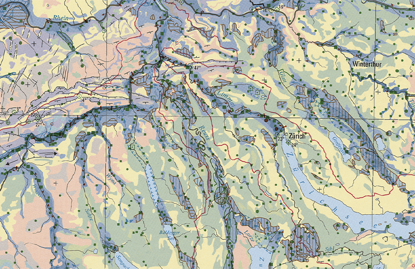
Das Bundesamt für Umwelt BAFU ist die zuständige Fachstelle der Landesgeologie für Hydrogeologie. Die Hydrogeologische Karte 1:500'000 ist in die Serie Geokarten (GK500) integriert und gliedert sich in zwei Blätter. Das erste (GK500-Hydro) stellt die verschiedenen Grundwasservorkommen der Schweiz und deren Ergiebigkeit, das zweite (GK500-Hydro_Vul) die Empfindlichkeit der Grundwasservorkommen bezüglich möglicher Gefährdungen durch Schadstoffe dar. Das Blatt Grundwasservorkommen zeigt zudem die Art der Grundwasserzirkulation (Karst-, Kluft- und Lockergesteine), die wichtigsten Quell- und Grundwasserfassungen sowie hydrodynamische Angaben zu den Infiltrations- und Exfiltrationsgebieten. Die beiden Blätter wurden ursprünglich als Tafeln 8.6 und 8.7 des Hydrologischen Atlas der Schweiz HADES (BAFU, 2004 und 2007) herausgegeben.
L’Office fédéral de l’environnement OFEV est l’office compétent du Service géologique national pour l'hydrogéologie. La Carte hydrogéologique 1:500'000 est dans la série GéoCartes (GK500) et composée de deux feuilles. La première (GK500-Hydro) est consacrée aux réservoirs aquifères et fournit des informations sur leur productivité. La seconde (GK500-Hydro_Vul) traite de la vulnérabilité de ces réservoirs et de leur sensibilité à des menaces possibles par des polluants. En outre la première feuille montre la nature des réservoirs aquifères (roches karstiques, meubles ou cohérentes), les principaux captages d'eau souterraine et d'eau de source et fournit des données hydrodynamiques sur les régions d'infiltration et d'exfiltration des eaux. Le contenu des deux feuilles est également publié comme Planche 8.6 et 8.7 de l'Atlas hydrologique de la Suisse HADES (OFEV, 2004 et 2007).
L'Ufficio federale dell'ambiente (UFAM) è il servizio competente per l’idrogeologia del Servizio geologico nazionale. La carta idrogeologica 1:500'000 è integrata nella serie Geocarte500 (GK500) ed è strutturata in due fogli. Il primo foglio (GK500-Hydro) è dedicato alle diverse falde acquifere della Svizzera e al loro rendimento, il secondo (GK500-Hydro_Vul) alla vulnerabilità delle falde acquifere con riferimento a potenziali pericoli da parte di agenti inquinanti. Il primo foglio mostra inoltre il tipo di circolazione delle falde acquifere (rocce carsiche, coerenti e incoerenti), i principali tipi di falde acquifere nonché informazioni idrodinamiche sulle zone di infiltrazione e di esfiltrazione. I due fogli sono stati pubblicati in origine sottoforma di tavole 8.6 e 8.7 dell'Atlante idrologico della Svizzera HADES (UFAM, 2004 e 2007).
The Federal Office for the Environment (FOEN) is the body within the Swiss Geological Survey responsible for hydrogeology. The 1:500,000 Hydrogeological Map forms part of the GeoMaps series (GK500) and is divided into two sheets. The first (GK500-Hydro) represents the various groundwater resources in Switzerland and their productiveness. The second (GK500-Hydro_Vul) shows the vulnerability of the groundwater resources to the risk of pollution. The groundwater resources sheet also indicates the type of groundwater aquifer (karstic, jointed or unconsolidated rock), the most important springs and groundwater catchments as well as hydrodynamic information about the infiltration and exfiltration areas. The two sheets were originally published as Tables 8.6 and 8.7 of the Hydrological Atlas of Switzerland HADES (FOEN, 2004 and 2007).
L'Uffizi federal d'ambient UFAM è il post spezialisà dal Servetsch geologic naziunal ch'è cumpetent per l'idrogeologia. La Charta idrogeologica 1:500'000 è integrada en la seria da las GeoChartas (GK500) e sa cumpona da dus fegls. L'emprim (GK500-Hydro) preschenta las differentas resursas d'aua sutterrana da la Svizra e lur productivitad, il segund (GK500-Hydro_Vul) la vulnerabilitad da las resursas d'aua sutterrana areguard eventualas periclitaziuns tras substanzas nuschaivlas. L'emprim fegl mussa ultra da quai il gener da las resursas d'aua sutterrana (crap carstic, crappa cun sfessas e crappa lucca), las tschiffadas las pli impurtantas da funtauna e d'aua sutterrana sco er indicaziuns idrodinamicas areguard ils territoris d'infiltraziun e d'exfiltraziun. Oriundamain èn ils dus fegls vegnids edids sco tavlas 8.6 ed 8.7 da l'Atlas idrologic da la Svizra HADES (UFAM, 2004 e 2007).
Simple
-
AlternativtitelAutres appellations ou acronymesTitolo alternativoAlternate titleAlternate title
-
Grundwasservorkommen 500
Réservoirs aquifères 500
Falde acquifere 500
Groundwater Resources 500
Resursas d'aua sutterrana 500
-
Date (Publication)Data (Pubblicazione)Date (Publication)Date (Publication)Datumsangaben (Publikation)
- 2007-09-14
-
IdentificateurIdentificatoreCitation identifierCitation identifierIdentifikator
- ch.swisstopo.geologie-hydrogeologische_karte-grundwasservorkommen
Identificateur
Identificatore
Citation identifier
Citation identifier
Identifikator
-
Forme de la présentationFormato di presentazionePresentation formPresentation formPräsentationsform
-
Carte papierMappa cartaceaHardcopy mapHardcopy mapAnaloge Karte
-
Forme de la présentationFormato di presentazionePresentation formPresentation formPräsentationsform
-
Carte numériqueMappa digitaleDigital mapDigital mapDigitale Karte
-
BezeichnungNomNomeName
-
GeoKarten 500
GéoCartes 500
GeoCarte 500
GeoMaps 500
-
Gemeinsamer TitelTitre collectifTitolo collettivoCollective title
-
Geologisches Kartenwerk
Cartes géologiques
Carte geologiche
Geological maps
-
EtatStatusStatusStatusBearbeitungsstatus
-
FinaliséCompletatoCompletedCompletedAbgeschlossen
- Point of contact
-
Organisation name Individual name Electronic mail address Role Bundesamt für Landestopografie swisstopo
Office fédéral de topographie swisstopo
Ufficio federale di topografia swisstopo
Federal Office of Topography swisstopo
Uffizi federal da topografia swisstopo
DistributeurDistributoreDistributorDistributorVertriebBundesamt für Landestopografie swisstopo
Office fédéral de topographie swisstopo
Ufficio federale di topografia swisstopo
Federal Office of Topography swisstopo
Uffizi federal da topografia swisstopo
Point de contactPunto di contattoPoint of contactPoint of contactAnsprechpartnerBundesamt für Landestopografie swisstopo
Office fédéral de topographie swisstopo
Ufficio federale di topografia swisstopo
Federal Office of Topography swisstopo
Uffizi federal da topografia swisstopo
PropriétaireProprietarioOwnerOwnerEigentümer / Datenherr
-
Fréquence de mise à jourFrequenza di aggiornamentoMaintenance and update frequencyMaintenance and update frequencyÜberarbeitungsintervall
-
Lorsque nécessaireSecondo necessitàAs neededAs neededBei Bedarf
-
geocat.ch
-
-
Aufbewahrungs- und Archivierungsplanung AAP - Bund
Planification de la conservation et de l'archivage AAP - Conféderation
Pianificazione della conservazione e dell’archiviazione AAP - Confederazione
Conservation and archiving planning AAP - Confederation
-
Geobasisdaten
géodonnées de base
geodati di base
official geodata
-
opendata.swiss
opendata.swiss
opendata.swiss
opendata.swiss
opendata.swiss
-
e-geo.ch
e-geo.ch
e-geo.ch
e-geo.ch
-
-
GEMET
-
-
Grundwasser
eaux souterraines
acqua sotterranea
groundwater
-
Geowissenschaften
sciences de la terre
scienze della terra
earth science
-
Grundwasserträger
aquifère
acquifero
aquifer
-
Hydrogeologie
hydrogéologie
idrogeologia
hydrogeology
-
-
GEMET - INSPIRE themes, version 1.0
-
-
Geologie
Géologie
Geologia
Geology
-
-
geocat.ch
-
-
BGDI Bundesgeodaten-Infrastruktur
IFDG l’Infrastructure Fédérale de données géographiques
IFDG Infrastruttura federale dei dati geografici
FSDI Federal Spatial Data Infrastructure
-
-
Type de représentation spatialeTipo di rappresentazione spazialeSpatial representation typeSpatial representation typeRäumliche Darstellungsart
-
RasterDati rasterGridGridRaster, Gitter
-
Type de représentation spatialeTipo di rappresentazione spazialeSpatial representation typeSpatial representation typeRäumliche Darstellungsart
-
VecteurDati vettorialiVectorVectorVektor
-
Type de représentation spatialeTipo di rappresentazione spazialeSpatial representation typeSpatial representation typeRäumliche Darstellungsart
-
paperMappaperMappaperMappaperMappaperMap
-
Dénominateur de l'échelleDenominatoreDenominatorDenominatorMassstabszahl
- 500000
-
Langue de la ressourceLingua dei datiLanguageLanguageSprache
- Deutsch
-
Langue de la ressourceLingua dei datiLanguageLanguageSprache
- Français
-
Encodage des caractèresSet dei caratteri dei datiCharacter setCharacter setZeichensatz
-
Utf8UTF8UTF8UTF8Utf8
-
Catégorie ISOTemaTopic categoryTopic categoryThematik
-
-
Sciences de la terre, géosciencesInformazioni geoscientificheGeoscientific informationGeoscientific informationGeowissenschaften
-
Étendue
Estensione
Extent
Extent
Ausdehnung
-
BeschreibungDescriptionDescrizioneDescriptionDescription
-
Landeskarte 1:500'000
Carte nationale 1:500'000
Carta nazionale 1:500'000
National Map 1:500'000
Landeskarte 1:500'000
))

-
Identifiant géographiqueidentificatore GeograficoGeographic identifierGeographic identifierGeografischer Identifikator
-
LK500CN500CN500NM500LK500
-
ZusatzinformationInformations supplémentaires
-
Diese Karte ist als Druckversion (gefalzt oder plano), Pixelkarte oder Vektordatensatz erhältlich.
Cette carte est disponibles en version imprimée (plié ou plano), carte-pixel et jeux de données vectorielles.
-
Nom du système de référenceIdentificatore del sistema di riferimentoReference system identifierReference system identifierIdentifikator des Referenzsystems
-
Referenzsystem entsprechend der zugrundeliegenden topographischen Karte (CH1903)Système de référence conformément à la carte topographique sous-jacente (CH1903)
- Distribution format
-
Name Version plano (gedruckt - imprimé - stampato - print)
-
GeoTIFF
-
ESRI Shapefile
-
- OnLine resource
-
Protocol Linkage Name MAP:Preview
https://map.geo.admin.ch/?layers=ch.swisstopo.geologie-hydrogeologische_karte-grundwasservorkommen Vorschau map.geo.admin.ch
Aperçu map.geo.admin.ch
Previsione map.geo.admin.ch
Preview map.geo.admin.ch
OGC:WMS
https://wms.geo.admin.ch/?SERVICE=WMS&VERSION=1.3.0&REQUEST=GetCapabilities&lang=de ch.swisstopo.geologie-hydrogeologische_karte-grundwasservorkommen
ch.swisstopo.geologie-hydrogeologische_karte-grundwasservorkommen
ch.swisstopo.geologie-hydrogeologische_karte-grundwasservorkommen
ch.swisstopo.geologie-hydrogeologische_karte-grundwasservorkommen
ch.swisstopo.geologie-hydrogeologische_karte-grundwasservorkommen
OGC:WMTS
https://wmts.geo.admin.ch/EPSG/3857/1.0.0/WMTSCapabilities.xml?lang=de ch.swisstopo.geologie-hydrogeologische_karte-grundwasservorkommen
ch.swisstopo.geologie-hydrogeologische_karte-grundwasservorkommen
ch.swisstopo.geologie-hydrogeologische_karte-grundwasservorkommen
ch.swisstopo.geologie-hydrogeologische_karte-grundwasservorkommen
ch.swisstopo.geologie-hydrogeologische_karte-grundwasservorkommen
- OnLine resource
-
Protocol Linkage Name WWW:LINK
https://shop.swisstopo.admin.ch/de/karten/geologische-karten/geokarten-500000 WWW:DOWNLOAD-URL
https://data.geo.admin.ch/ch.swisstopo.geologie-hydrogeologische_karte-grundwasservorkommen CHTOPO:specialised-geoportal
https://map.geo.admin.ch/?lang=de&topic=gewiss WWW:LINK
https://www.bafu.admin.ch/bafu/de/home/themen/wasser.html WWW:LINK
https://www.geologieportal.ch/de/themen/wasser/grundwasser.html ESRI:REST
https://api3.geo.admin.ch/rest/services/api/MapServer/ch.swisstopo.geologie-hydrogeologische_karte-grundwasservorkommen RESTful API von geo.admin.ch
RESTful API de geo.admin.ch
RESTful API da geo.admin.ch
RESTful API from geo.admin.ch
RESTful API dad geo.admin.ch
OPENDATA:SWISS
https://opendata.swiss/de/perma/f198f6f6-8efa-4235-a55f-99767ea0206c@bundesamt-fur-landestopografie-swisstopo Permalink opendata.swiss
Permalink opendata.swiss
Permalink opendata.swiss
Permalink opendata.swiss
Metadata
-
Identifiant de la ficheIdentificatore del file di metadatiFile identifierFile identifierMetadatensatzidentifikator
- f198f6f6-8efa-4235-a55f-99767ea0206c XML
-
LangueLingua dei metadatiMetadata languageMetadata languageSprache
- Deutsch
-
Jeu de caractèresSet dei caratteri dei metadatiCharacter setCharacter setZeichensatz
-
Utf8UTF8UTF8UTF8Utf8
-
Type de ressourceLivello gerarchicoHierarchy levelHierarchy levelHierarchieebene
-
Jeu de donnéesDatasetDatasetDatasetDatenbestand
-
Date des métadonnéesData dei metadatiDate stampDate stampDatum
- 2022-10-21T07:55:02
- Metadata standard name
-
GM03 2+
- Metadata author
-
Organisation name Individual name Electronic mail address Role Bundesamt für Landestopografie swisstopo
Office fédéral de topographie swisstopo
Ufficio federale di topografia swisstopo
Federal Office of Topography swisstopo
Uffizi federal da topografia swisstopo
Point de contactPunto di contattoPoint of contactPoint of contactAnsprechpartner
- Other language
-
Language Character encoding FrançaisFranceseFrenchFrenchFranzösischUtf8UTF8UTF8UTF8Utf8ItalienItalianoItalianItalianItalienischUtf8UTF8UTF8UTF8Utf8AnglaisIngleseEnglishEnglishEnglischUtf8UTF8UTF8UTF8Utf8RomancheRomancioRomanshRomanshRätoromanischUtf8UTF8UTF8UTF8Utf8AllemandTedescoGermanGermanDeutschUtf8UTF8UTF8UTF8Utf8