INSPIRE Geoportal
Geologische Generalkarte der Schweiz 1:200000
Carte géologique générale de la Suisse au 1:200000
Carta geologica generale della Svizzera 1:200000
General Geological Map of Switzerland 1:200,000
Charta geologica generala da la Svizra 1:200000
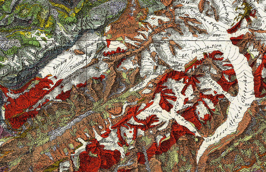
Auf der Dufourkarte basierendes gesamtschweizerisches geologisches Kartenwerk. In acht Blättern, zwischen 1942 und 1964 erschienen, ist die geologische Generalkarte der Schweiz (GGK200) ein historisches Werk höchster Qualität. Die gedruckten Versionen der Blätter der Geologischen Generalkarte sind teilweise vergriffen, jedoch ist jedes Blatt als Pixelkarte erhältlich.
Ensemble de cartes géologiques de la Suisse basées sur la carte Dufour. En huit feuilles parues entre 1942 et 1964, la carte géologique générale de la Suisse (GGK200) constitue un ouvrage historique de qualité très élevée. Les versions imprimées de la Carte générale géologique sont en partie épuisées, cependant chaque feuille est disponible en version carte-pixel.
Opera cartografica geologica della Svizzera basata sulla carta Dufour. Con i suoi otto fogli pubblicati tra il 1942 e il 1964, la carta geologica generale della Svizzera (GGK200) costituisce un'opera storica di altissima qualità. Le versioni cartacee dei fogli della carta geologica generale sono in parte esauriti; ciascuno dei fogli è tuttavia disponibile sotto forma di carta pixel.
Geological mapping of the whole country based on the Dufour Map of Switzerland. Comprised of eight sheets, published between 1942 and 1964, the General Geological Map of Switzerland (GGK200) is a historical document of the highest quality. The printed versions of the sheets of the General Geological Map are partially out of print, but each sheet is available as a pixel map.
Ovra da chartas geologicas naziunala che sa basa sin la charta Dufour. En otg fegls ch'èn cumparids dal 1942 fin il 1964 è la charta geologica generala da la Svizra (GGK200) in'ovra istorica d'excellenta qualitad. Las versiuns stampadas dals fegls da la charta geologica generala èn per part exaustas, ma mintga fegl pon ins retrair sco charta da pixels.
Simple
-
AlternativtitelAutres appellations ou acronymesTitolo alternativoAlternate titleAlternate title
-
Geol. Generalkarte 200
Carte géol. générale 200
Carta geol. generale 200
General Geol. Map 200
Charta geol. generala 200
-
Date (Création)Data (Creazione)Date (Creation)Date (Creation)Datumsangaben (Erstellung)
- 1964-12-31
-
Date (lastRevision)Data (lastRevision)Date (lastRevision)Date (lastRevision)Datumsangaben (lastRevision)
- 1965-01-01T00:00:00
-
IdentificateurIdentificatoreCitation identifierCitation identifierIdentifikator
- ch.swisstopo.geologie-generalkarte-ggk200
Identificateur
Identificatore
Citation identifier
Citation identifier
Identifikator
-
Forme de la présentationFormato di presentazionePresentation formPresentation formPräsentationsform
-
Carte papierMappa cartaceaHardcopy mapHardcopy mapAnaloge Karte
-
Forme de la présentationFormato di presentazionePresentation formPresentation formPräsentationsform
-
Carte numériqueMappa digitaleDigital mapDigital mapDigitale Karte
-
Gemeinsamer TitelTitre collectifTitolo collettivo
-
Geologisches Kartenwerk
Cartes géologiques
Carte geologiche
-
EtatStatusStatusStatusBearbeitungsstatus
-
FinaliséCompletatoCompletedCompletedAbgeschlossen
- Point of contact
-
Organisation name Individual name Electronic mail address Role Bundesamt für Landestopografie swisstopo
Office fédéral de topographie swisstopo
Ufficio federale di topografia swisstopo
Federal Office of Topography swisstopo
Uffizi federal da topografia swisstopo
DistributeurDistributoreDistributorDistributorVertriebBundesamt für Landestopografie swisstopo
Office fédéral de topographie swisstopo
Ufficio federale di topografia swisstopo
Federal Office of Topography swisstopo
Uffizi federal da topografia swisstopo
Point de contactPunto di contattoPoint of contactPoint of contactAnsprechpartnerBundesamt für Landestopografie swisstopo
Office fédéral de topographie swisstopo
Ufficio federale di topografia swisstopo
Federal Office of Topography swisstopo
Uffizi federal da topografia swisstopo
PropriétaireProprietarioOwnerOwnerEigentümer / Datenherr
-
Fréquence de mise à jourFrequenza di aggiornamentoMaintenance and update frequencyMaintenance and update frequencyÜberarbeitungsintervall
-
Non planifiéeNon pianificatoNot plannedNot plannedNicht geplant
-
geocat.ch
-
-
Historische Karte
carte historique
carta storica
historic map
-
opendata.swiss
opendata.swiss
opendata.swiss
opendata.swiss
opendata.swiss
-
Geologische Karte
carte géologique
carta geologica
geologic map
-
Geobasisdaten
géodonnées de base
geodati di base
official geodata
-
Aufbewahrungs- und Archivierungsplanung AAP - Bund
Planification de la conservation et de l'archivage AAP - Conféderation
Pianificazione della conservazione e dell’archiviazione AAP - Confederazione
Conservation and archiving planning AAP - Confederation
-
-
GEMET - INSPIRE themes, version 1.0
-
-
Geologie
Géologie
Geologia
Geology
-
-
GEMET
-
-
Geowissenschaften
sciences de la terre
scienze della terra
earth science
-
Sedimentation (geologisch)
sédimentation
sedimentazione (geologia)
sedimentation (geology)
-
Gestein
pierre
pietra (edilizia)
stone
-
-
geocat.ch
-
-
BGDI Bundesgeodaten-Infrastruktur
IFDG l’Infrastructure Fédérale de données géographiques
IFDG Infrastruttura federale dei dati geografici
FSDI Federal Spatial Data Infrastructure
-
-
Andere EinschränkungenAutres contraintesOther constraints
-
Freie Nutzung. Quellenangabe ist Pflicht.
Utilisation libre. Obligation d’indiquer la source.
NonCommercialAllowed-CommercialAllowed-ReferenceRequired
-
Type de représentation spatialeTipo di rappresentazione spazialeSpatial representation typeSpatial representation typeRäumliche Darstellungsart
-
RasterDati rasterGridGridRaster, Gitter
-
Type de représentation spatialeTipo di rappresentazione spazialeSpatial representation typeSpatial representation typeRäumliche Darstellungsart
-
paperMappaperMappaperMappaperMappaperMap
-
Dénominateur de l'échelleDenominatoreDenominatorDenominatorMassstabszahl
- 200000
-
Langue de la ressourceLingua dei datiLanguageLanguageSprache
- Deutsch
-
Langue de la ressourceLingua dei datiLanguageLanguageSprache
- Français
-
Encodage des caractèresSet dei caratteri dei datiCharacter setCharacter setZeichensatz
-
Utf8UTF8UTF8UTF8Utf8
-
Catégorie ISOTemaTopic categoryTopic categoryThematik
-
-
Sciences de la terre, géosciencesInformazioni geoscientificheGeoscientific informationGeoscientific informationGeowissenschaften
-
Étendue
Estensione
Extent
Extent
Ausdehnung
-
BeschreibungDescriptionDescrizioneDescription
-
Geologische Generalkarte 1:200@squot;000
Carte géologique générale 1:200@squot;000
Carta geologica generale 1:200@squot;000
General Geological Map 1:200@squot;000
))

-
Identifiant géographiqueidentificatore GeograficoGeographic identifierGeographic identifierGeografischer Identifikator
-
GGK200GGK200GGK200GGK200null
-
ZusatzinformationInformations supplémentaires
-
Einige Karten sind vergriffen, jedoch sind alle im Rasterformat erhältlich.
Les versions imprimées sont en partie épuisées, cependant chaque feuille est disponible en version carte-pixel.
-
Nom du système de référenceIdentificatore del sistema di riferimentoReference system identifierReference system identifierIdentifikator des Referenzsystems
-
Referenzsystem entsprechend der zugrundeliegenden topographischen Karte (CH1903)
- Distribution format
-
Name Version GeoTIFF
-
- OnLine resource
-
Protocol Linkage Name MAP:Preview
https://map.geo.admin.ch/?layers=ch.swisstopo.geologie-generalkarte-ggk200 Vorschau map.geo.admin.ch
Aperçu map.geo.admin.ch
Previsione map.geo.admin.ch
Preview map.geo.admin.ch
OGC:WMS
https://wms.geo.admin.ch/?SERVICE=WMS&VERSION=1.3.0&REQUEST=GetCapabilities&lang=de ch.swisstopo.geologie-generalkarte-ggk200
ch.swisstopo.geologie-generalkarte-ggk200
ch.swisstopo.geologie-generalkarte-ggk200
ch.swisstopo.geologie-generalkarte-ggk200
ch.swisstopo.geologie-generalkarte-ggk200
OGC:WMTS
https://wmts.geo.admin.ch/EPSG/3857/1.0.0/WMTSCapabilities.xml?lang=de ch.swisstopo.geologie-generalkarte-ggk200
ch.swisstopo.geologie-generalkarte-ggk200
ch.swisstopo.geologie-generalkarte-ggk200
ch.swisstopo.geologie-generalkarte-ggk200
ch.swisstopo.geologie-generalkarte-ggk200
- OnLine resource
-
Protocol Linkage Name WWW:LINK
https://www.swisstopo.admin.ch/de/geodata/geology/maps/ggk.html Produkte- und Bestellinformationen
WWW:DOWNLOAD-URL
https://data.geo.admin.ch/ch.swisstopo.geologie-generalkarte-ggk200/data.zip
- OnLine resource
-
Protocol Linkage Name CHTOPO:specialised-geoportal
http://map.geologieportal.ch Geologischer Datenviewer
OPENDATA:SWISS
https://opendata.swiss/de/perma/f6416e51-bf55-445a-946e-3eee2134d131@bundesamt-fur-landestopografie-swisstopo Permalink opendata.swiss
Permalink opendata.swiss
Permalink opendata.swiss
Permalink opendata.swiss
-
NiveauLivelloHierarchy levelHierarchy levelBezugsebene
-
Jeu de donnéesDatasetDatasetDatasetDatenbestand
-
ErläuterungGénéralités sur la provenance
-
Auf der Dufourkarte basierendes gesamtschweizerisches geologische Kartenwerk. Die geologische Generalkarte bildet ein historisches Werk höchster Qualität.
Ensemble de cartes géologiques de la Suisse basées sur la carte Dufour. La carte géologique générale constitue un ouvrage historique de qualité très élevée.
Metadata
-
Identifiant de la ficheIdentificatore del file di metadatiFile identifierFile identifierMetadatensatzidentifikator
- f6416e51-bf55-445a-946e-3eee2134d131 XML
-
LangueLingua dei metadatiMetadata languageMetadata languageSprache
- Deutsch
-
Jeu de caractèresSet dei caratteri dei metadatiCharacter setCharacter setZeichensatz
-
Utf8UTF8UTF8UTF8Utf8
-
Type de ressourceLivello gerarchicoHierarchy levelHierarchy levelHierarchieebene
-
Jeu de donnéesDatasetDatasetDatasetDatenbestand
-
Date des métadonnéesData dei metadatiDate stampDate stampDatum
- 2022-04-06T05:59:15
- Metadata standard name
-
GM03 2+
- Metadata author
-
Organisation name Individual name Electronic mail address Role Bundesamt für Landestopografie swisstopo
Office fédéral de topographie swisstopo
Ufficio federale di topografia swisstopo
Federal Office of Topography swisstopo
Uffizi federal da topografia swisstopo
Point de contactPunto di contattoPoint of contactPoint of contactAnsprechpartner
- Other language
-
Language Character encoding FrançaisFranceseFrenchFrenchFranzösischUtf8UTF8UTF8UTF8Utf8ItalienItalianoItalianItalianItalienischUtf8UTF8UTF8UTF8Utf8AnglaisIngleseEnglishEnglishEnglischUtf8UTF8UTF8UTF8Utf8RomancheRomancioRomanshRomanshRätoromanischUtf8UTF8UTF8UTF8Utf8AllemandTedescoGermanGermanDeutschUtf8UTF8UTF8UTF8Utf8