INSPIRE Geoportal
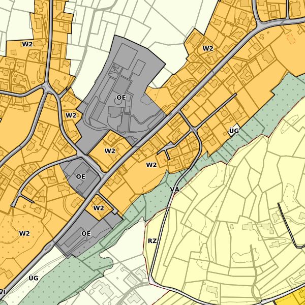
Zonenplan der Gemeinde Gamprin
Der Zonenplan Gamprin wird gemäss Baugesetz, Art. 12, hauptsächlich aus den vier digitalen Themen Grundnutzungsflächen, Schutzobjekte, Planungsinstrumente sowie Abbau/Deponie erstellt. Er bildet das gesamte Gemeindegebiet ab. Für Kontrollzwecke kann der rechtsgültige Zonenplan mit weiteren überlagernden Themen sowie mit Bauordnung bei der Gemeinde bezogen bzw. auf deren Startseite heruntergeladen werden.
Simple
-
Alternativtitel
-
Zonenplan Gamprin
-
Date (Publication)Data (Pubblicazione)Date (Publication)Datumsangaben (Publikation)
- 2014-04-09
-
IdentificateurIdentificatoreCitation identifierIdentifikator
- abi_zonenplan_gamp
-
Zweck
-
Digitale Planungsgrundlage
-
EtatStatusStatusBearbeitungsstatus
-
FinaliséCompletatoCompletedAbgeschlossen
- Point of contact
-
Organisation name Individual name Electronic mail address Role Gemeinde Gamprin
Point de contactPunto di contattoPoint of contactAnsprechpartner
-
Fréquence de mise à jourFrequenza di aggiornamentoMaintenance and update frequencyÜberarbeitungsintervall
-
Lorsque nécessaireSecondo necessitàAs neededBei Bedarf
- Resource format
-
Name Version INTERLIS 1 (ITF)
-
GEMET
-
-
Vektor
vecteur
vettore
vector
-
-
GEMET - INSPIRE themes, version 1.0
-
-
Bodennutzung
Usage des sols
Utilizzo del territorio
Land use
-
Schutzgebiete
Sites protégés
Siti protetti
Protected sites
-
-
geocat.ch
-
-
INSPIRE
INSPIRE
INSPIRE
INSPIRE
-
Grundnutzung
affectation primaire
utilizzazione di base
primary use
-
Gestaltungsplan
plan d'aménagement
piano d'edificabilità
development plan
-
Bauzone
zone à bâtir
zona edificabile
construction zone
-
Zone
zone
zona
zone
-
-
Spatial scope
-
-
Lokal
Local
Locali
Local
-
-
GEMET
-
-
Bauabfälle
déchets de construction
rifiuti da costruzione
construction waste
-
-
Anwendungseinschränkungen
-
gebührenpflichtig
-
Contraintes d'accèsVincoli di accessoAccess constraintsZugriffseinschränkungen
-
LicenceLicenzaLicenseLizenz
-
Contraintes d'utilisationVincoli di fruibilitàUse constraintsNutzungseinschränkungen
-
LicenceLicenzaLicenseLizenz
-
Type de représentation spatialeTipo di rappresentazione spazialeSpatial representation typeRäumliche Darstellungsart
-
VecteurDati vettorialiVectorVektor
-
Dénominateur de l'échelleDenominatoreDenominatorMassstabszahl
- 500
-
Langue de la ressourceLingua dei datiLanguageSprache
- Deutsch
-
Encodage des caractèresSet dei caratteri dei datiCharacter setZeichensatz
-
Utf8UTF8UTF8Utf8
-
Catégorie ISOTemaTopic categoryThematik
-
-
Cadastre, aménagementPianificazione del territorio e catastoPlanning cadastrePlanungsunterlagen, Kataster
-
Étendue
Estensione
Extent
Ausdehnung
-
BeschreibungDescriptionDescrizioneDescription
-
Gamprin FL
Gamprin FL
Gamprin FL
Gamprin FL
))

-
Identifiant géographiqueidentificatore GeograficoGeographic identifierGeografischer Identifikator
-
GamprinGamprinGamprinGamprin
-
Nom du système de référenceIdentificatore del sistema di riferimentoReference system identifierIdentifikator des Referenzsystems
-
http://www.opengis.net/def/crs/EPSG/0/2056
-
Nom du système de référenceIdentificatore del sistema di riferimentoReference system identifierIdentifikator des Referenzsystems
-
http://www.opengis.net/def/crs/EPSG/0/4936
-
Niveau topologieLivello di topologiaTopology levelTopologielevel
-
Topologie de réseau complèteGrafo planare completoFull planar graphFlächen
-
Type de géométries des objetsOggetto di tipo geometricoGeometric object typeGeometrietyp
-
PolygoneSuperficieSurfaceFläche
-
Nombre d'objets géométriquesConteggio oggetto geometricoGeometric object countAnzahl
- 1426
- Distribution format
-
Name Version INTERLIS 1 (ITF)
AutoCAD DXF (DXF)
ESRI Shapefile (SHP)
- Distributor contact
-
Organisation name Individual name Electronic mail address Role Abt. Vermessung und Geoinformation (ATG)
Abt. Vermessung und Geoinformation (ATG)
Abt. Vermessung und Geoinformation (ATG)
Abt. Vermessung und Geoinformation (ATG)
Point de contactPunto di contattoPoint of contactAnsprechpartner
- Distributor contact
-
Organisation name Individual name Electronic mail address Role Gemeinde Gamprin
Point de contactPunto di contattoPoint of contactAnsprechpartner
- OnLine resource
-
Protocol Linkage Name WWW:LINK
https://www.gamprin.li Startseite der Gemeinde Gamprin
WWW:LINK
https://www.llv.li/inhalt/1627/amtsstellen/datenausgabe Startseite ABI, Datenausgabestelle
-
NiveauLivelloHierarchy levelBezugsebene
-
Jeu de donnéesDatasetDatasetDatenbestand
Résultat de conformité
Conformità
Conformance result
Konformitätsergebnis
-
Date (Publication)Data (Pubblicazione)Date (Publication)Datumsangaben (Publikation)
- 2010-12-08
- Explanation
-
Gemäss INSPIRE Bestandteil der Themen "Schutzgebiete", "Bodennutzung" sowie "Versorgungswirtchaft und staatliche Dienste"
-
Degré de conformitéPassPassBestanden
- No
-
Erläuterung
-
Konstruktion auf der Grundlage der Amtlichen Vermessung
-
Inclus dans le jeu de donnéesIncluded with datasetIncluded with datasetIm Datenbestand enthalten
- No
-
Date (Révision)Data (Revisione)Date (Revision)Datumsangaben (Überarbeitung)
- 2015-01-29
Metadata
-
Identifiant de la ficheIdentificatore del file di metadatiFile identifierMetadatensatzidentifikator
- f7712474-0ecb-4e4b-915d-450030cfc4c4 XML
-
LangueLingua dei metadatiMetadata languageSprache
- Deutsch
-
Jeu de caractèresSet dei caratteri dei metadatiCharacter setZeichensatz
-
Utf8UTF8UTF8Utf8
-
Type de ressourceLivello gerarchicoHierarchy levelHierarchieebene
-
Jeu de donnéesDatasetDatasetDatenbestand
-
Date des métadonnéesData dei metadatiDate stampDatum
- 2023-03-07T14:58:05.304Z
- Metadata standard name
-
GM03 2+
- Metadata author
-
Organisation name Individual name Electronic mail address Role Abt. Vermessung und Geoinformation (ATG)
Abt. Vermessung und Geoinformation (ATG)
Abt. Vermessung und Geoinformation (ATG)
Abt. Vermessung und Geoinformation (ATG)
Point de contactPunto di contattoPoint of contactAnsprechpartner
- Other language
-
Language Character encoding FrançaisFranceseFrenchFranzösischUtf8UTF8UTF8Utf8ItalienItalianoItalianItalienischUtf8UTF8UTF8Utf8AnglaisIngleseEnglishEnglischUtf8UTF8UTF8Utf8AllemandTedescoGermanDeutschUtf8UTF8UTF8Utf8