 INSPIRE Geoportal
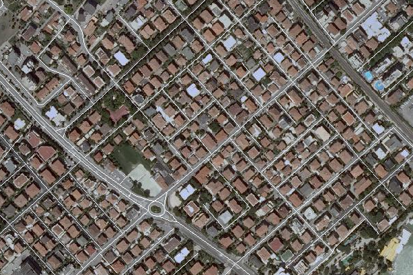
DBTR - Elemento stradale - (EST_GLI)
Rappresenta i flussi di circolazione nell'Area stradale ed in genere corrisponde alla mezzeria della carreggiata laddove questa è ben distinta, cioè alla mezzeria dell'Area di circolazione veicolare di tipo "tronco di carreggiata" contenuta nell'area stradale. Anche aree di circolazione pedonale vengono sintetizzate in Elementi stradali qualora siano caratterizzate da toponimi propri o garantiscano l'accesso a numeri civici. Infine danno luogo ad elementi stradali anche quelle idrovie che garantiscono il raccordo tra sottoreti stradali
Simple
- Date (Creation)
- 2021-01-01
- Date (Publication)
- 2021-01-01
- Date (Revision)
- 2021-01-01
- Citation identifier
- r_emiro:DBTR:EST_GLI
- Cited responsible party
-
Organisation name Individual name Electronic mail address Role Regione Emilia-Romagna
Regione Emilia-Romagna
n.d.
Owner Regione Emilia-Romagna
Servizio Statistica e Sistemi informativi geografici
Serviziostatistica@regione.emi Serviziostatistica@regione.emilia-romagna.it
Author
- Presentation form
- Digital map
- Issue identification
-
r_emiro:DBTR
- Other citation details
-
Comprende gli oggetti della classe Elemento stradale
- Point of contact
-
Organisation name Individual name Electronic mail address Role Regione Emilia-Romagna
Archivio Cartografico
archiviocart@regione.emi archiviocart@regione.emilia-romagna.it
Point of contact
-
GEMET - Concepts, version 3.1
-
-
veicolo
-
sistema informativo geografico
-
cartografia
-
-
Regione
-
-
EU
-
Regionale
-
open data
-
circolazione stradale
-
elemento stradale
-
area stradale
-
veicolare
-
ctr
-
cartografia tecnica regionale
-
database topografico
-
strade
-
viabilità mobilità trasporti
-
dbtr
-
topografia
-
-
GEMET - INSPIRE themes, version 1.0
-
-
Reti di trasporto
-
- Use limitation
-
CC BY 3.0 (Creative Commons - Attribuzione) https://creativecommons.org/licenses/by/3.0/legalcode.it
- Access constraints
- Other restrictions
- Other constraints
- Accesso pubblico limitato in accordo all Articolo 13(1)(e) della Direttiva INSPIRE
- Use constraints
- Other restrictions
- Other constraints
- CC BY 3.0 (Creative Commons - Attribuzione)
- Classification
- Unclassified
- Spatial representation type
- Vector
- Denominator
- 5000
- Language
- Italiano
- Character set
- UTF8
- Topic category
-
- Imagery base maps earth cover
- Transportation
- Description
-
Regione Emilia Romagna ETRS89 / UTM Zone 32N
))
- Geographic identifier
- X5090
- Begin date
- 1999-12-31
- End date
- 2021-12-31
- Reference system identifier
- http://www.epsg-registry.org/export.htm?gml=urn:ogc:def:crs:EPSG::3003 / ROMA40/OVEST
- Distribution format
-
Name Version SHP
Ver1000
Vettoriale
Ver1000
WMS
1.3.0
Distributor
- Distributor contact
-
Organisation name Individual name Electronic mail address Role Regione Emilia-Romagna
Archivio Cartografico
archiviocart@regione.emi archiviocart@regione.emilia-romagna.it
Distributor
- Fees
-
Non in vendita
- OnLine resource
-
Protocol Linkage Name Link https://geoportale.regione.emilia-romagna.it/catalogo/dati-cartografici/cartografia-di-base/database-topografico-regionale/gestione-viabilita-e-indirizzi/amministrazione-viabilita Geoportale
WWW:LINK http://mappegis.regione.emilia-romagna.it/archiviogis/dbtr/Documenti/specifiche_di_contenuto_dbtr.pdf Specifica della classe Elemento stradale
OGC Web Map Service http://servizigis.regione.emilia-romagna.it/wms/dbtr?service=WMS&version=1.3.0&request=GetCapabilities EST_Elemento_stradale
WWW:DOWNLOAD https://geoportale.regione.emilia-romagna.it/download/download-data?type=dbtopo Download dal Database Topografico Regionale
Link https://geoportale.regione.emilia-romagna.it/approfondimenti/database-topografico-regionale DBTR Geoportale
- Hierarchy level
- Dataset
Quantitative result
- Value
- 4
Domain consistency
Conformance result
- Date (Publication)
- 2010-12-08
- Explanation
-
REGOLAMENTO (UE) N. 1089/2010 DELLA COMMISSIONE del 23 novembre 2010 recante attuazione della direttiva 2007/2/CE del Parlamento europeo e del Consiglio per quanto riguarda l'interoperabilità dei set di dati territoriali e dei servizi di dati territoriali
- Pass
- No
Conformance result
- Date (Publication)
- 2011-12-18
- Explanation
-
Capitolato tecnico per la realizzazione dell'aggiornamento 2008 del DB dell'Uso del Suolo e per il completamento e aggiornamento del DB Topografico
- Pass
- Yes
- Statement
-
La componente geometrica degli oggetti viene prodotta conformemente ai dati topografici del DBT e viene integrata con le proprietà desunte dagli strati CGU versione 2010 e Agea 2008, Agea 2011 e Agea2014
Metadata
- File identifier
- r_emiro:2017-11-24T131306 XML
- Metadata language
- Italiano
- Character set
- UTF8
- Hierarchy level
- Dataset
- Date stamp
- 2021-05-25
- Metadata standard name
-
Linee Guida RNDT
- Metadata standard version
-
2.0
- Metadata author
-
Organisation name Individual name Electronic mail address Role Servizio Statistica e Sistemi informativi geografici - Regione Emilia-Romagna
Stefano Olivucci
solivucci@regione.emi solivucci@regione.emilia-romagna.it
Point of contact
Overviews
Spatial extent
Provided by
