 INSPIRE Geoportal
XDBTR - Alveo - (AAI_GPG) Edizione 2020
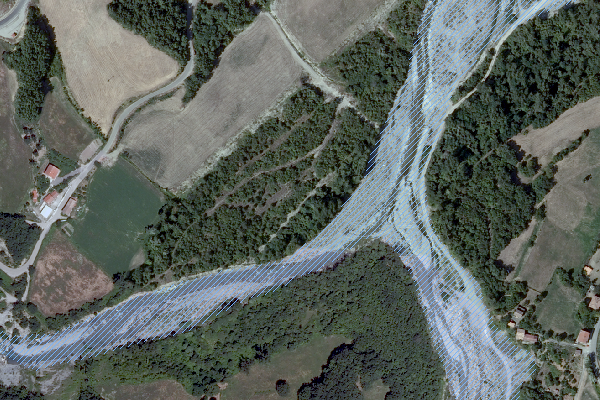
Definisce l'alveo di un corso d'acqua.Strato vettoriale della classe "Alvei" del DBTR, aggiornato esclusivamente per i corsi d'acqua principali, mediante ortofoto 2014 e sulla base del modello Lidar 2009-13 con metodologia condivisa nell'ambito del processo di adeguamento del Piano Territoriale Paesistico Regionale al DLGS 42/2004.I prodotti dal punto di vista della georeferenziazione e dell'inquadramento cartografico sono congruenti con il Database Topografico entro il limite di accuratezza tipo di una cartografia alla scala 1:10.000, consentendo così una confrontabilità geografica diretta fatto salvo il diverso grado di accuratezza temporale.Per maggiori informazioni, consultare il documento "Nuova versione delle classi Argine e Alveo del Database Topografico Regionale - Linee guida della metodologia di aggiornamento" all'indirizzo: https://geoportale.regione.emilia-romagna.it/approfondimenti/contenuti-allegati/realizzazione-argini-e-alvei-2018.pdf
Simple
- Date (Creation)
- 2020-01-01
- Date (Publication)
- 2020-01-01
- Date (Revision)
- 2020-01-01
- Citation identifier
- r_emiro:2020-03-26T094237
- Cited responsible party
-
Organisation name Individual name Electronic mail address Role Regione Emilia-Romagna
Regione Emilia-Romagna
n.d.
Owner Regione Emilia-Romagna
Settore innovazione digitale, dati, tecnologia e polo archivistico
ICT@Regione.Emi ICT@Regione.Emilia-Romagna.it
Author
- Presentation form
- Digital map
- Issue identification
-
r_emiro:2022-10-24T134757
- Other citation details
-
Comprende gli oggetti della classe 'Alveo'
- Point of contact
-
Organisation name Individual name Electronic mail address Role Regione Emilia-Romagna
Archivio Cartografico
archiviocart@regione.emi archiviocart@regione.emilia-romagna.it
Point of contact
-
GEMET - Concepts, version 3.1
-
-
sistema informativo geografico
-
orografia
-
corso d'acqua
-
alveo fluviale
-
cartografia
-
-
Regione
-
-
EU
-
Regionale
-
ctr
-
cartografia tecnica regionale
-
database topografico
-
topografia
-
dbtr
-
forma del terreno
-
-
GEMET - INSPIRE themes, version 1.0
-
-
Idrografia
-
- Use limitation
-
CC BY 3.0 (Creative Commons - Attribuzione) https://creativecommons.org/licenses/by/3.0/legalcode.it
- Access constraints
- Other restrictions
- Other constraints
- Nessuna limitazione all'accesso pubblico
- Use constraints
- Other restrictions
- Other constraints
- CC BY 3.0 (Creative Commons - Attribuzione)
- Classification
- Unclassified
- Spatial representation type
- Vector
- Denominator
- 5000
- Language
- Italiano
- Character set
- UTF8
- Topic category
-
- Imagery base maps earth cover
- Inland waters
- Description
-
Intero territorio della Regione Emilia-Romagna
))
- Geographic identifier
- X3001
- Begin date
- 2013-01-01
- End date
- 2017-12-31
- Reference system identifier
- http://www.epsg-registry.org/export.htm?gml=urn:ogc:def:crs:EPSG::4326 / WGS84
- Reference system identifier
- http://www.epsg-registry.org/export.htm?gml=urn:ogc:def:crs:EPSG::3003 / ROMA40/OVEST
- Reference system identifier
- http://www.epsg-registry.org/export.htm?gml=urn:ogc:def:crs:EPSG::23032 / ED50/UTM 32N
- Reference system identifier
- http://www.epsg-registry.org/export.htm?gml=urn:ogc:def:crs:EPSG::23033 / ED50/UTM 33N
- Reference system identifier
- http://www.epsg-registry.org/export.htm?gml=urn:ogc:def:crs:EPSG::32632 / WGS84/UTM 32N
- Reference system identifier
- http://www.epsg-registry.org/export.htm?gml=urn:ogc:def:crs:EPSG::32633 / WGS84/UTM 33N
- Reference system identifier
- http://www.epsg-registry.org/export.htm?gml=urn:ogc:def:crs:EPSG::4806 / ROMA40/ROMA
- Reference system identifier
- http://www.epsg-registry.org/export.htm?gml=urn:ogc:def:crs:EPSG::25832 / ETRS89/UTM-ZONE32N
- Reference system identifier
- http://www.epsg-registry.org/export.htm?gml=urn:ogc:def:crs:EPSG::25833 / ETRS89/UTM-ZONE33N
- Reference system identifier
- http://www.epsg-registry.org/export.htm?gml=urn:ogc:def:crs:EPSG::5659 / Monte Mario / TM Emilia-Romagna
- Reference system identifier
- http://www.epsg-registry.org/export.htm?gml=urn:ogc:def:crs:EPSG::7791 / RDN2008/UTM zone 32N
- Distribution format
-
Name Version SHP
n.d.
Vettoriale
n.d.
WMS
1.3.0
Distributor
- Distributor contact
-
Organisation name Individual name Electronic mail address Role Regione Emilia-Romagna
Archivio Cartografico
archiviocart@regione.emi archiviocart@regione.emilia-romagna.it
Distributor
- Fees
-
Non in vendita
- OnLine resource
-
Protocol Linkage Name WWW:LINK https://geoportale.regione.emilia-romagna.it/approfondimenti/contenuti-allegati/realizzazione-argini-e-alvei-2018.pdf Linee guida della metodologia di aggiornamento
OGC Web Map Service https://servizigis.regione.emilia-romagna.it/wms/xdbtr?service=wms%26request=getcapabilities%26version=1.3.0 Alveo_AAI_ed2020
- Hierarchy level
- Dataset
Quantitative result
- Value
- 4
Conformance result
- Date (Publication)
- 2010-12-08
- Explanation
-
REGOLAMENTO (UE) N. 1089/2010 DELLA COMMISSIONE del 23 novembre 2010 recante attuazione della direttiva 2007/2/CE del Parlamento europeo e del Consiglio per quanto riguarda l'interoperabilità dei set di dati territoriali e dei servizi di dati territoriali
- Pass
- No
- Statement
-
Le fonti sono costituite da:- Dati Lidar 2013.- Ortofoto immagine Agea 2014.- Classe argini (ARG) e alveo (AAI) del DBTR scaricate dal “Data Base Nightly”- Alvei dei corsi d'acqua di montagna forniti dal Servizio Geologico, Sismico e dei Suoli della Regione Emilia-Romagna.
Metadata
- File identifier
- r_emiro:2020-03-26T094236 XML
- Metadata language
- Italiano
- Character set
- UTF8
- Parent identifier
-
XDBTR - Alveo - (AAI_GPG) Edizione 2020
r_emiro:2020-03-26T094236
- Hierarchy level
- Dataset
- Date stamp
- 2023-03-06
- Metadata standard name
-
Linee Guida RNDT
- Metadata standard version
-
2.0
- Metadata author
-
Organisation name Individual name Electronic mail address Role Settore innovazione digitale, dati, tecnologia e polo archivistico - Regione Emilia-Romagna
Stefano Olivucci
stefano.olivucci@regione.emi stefano.olivucci@regione.emilia-romagna.it
Point of contact
Overviews
Spatial extent
Provided by
