 INSPIRE Geoportal
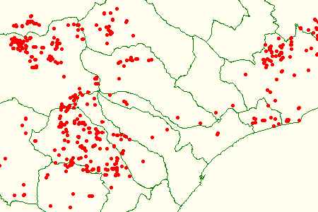
Grotte sc. 1:25000
La Regione Liguria gestisce il Catasto Speleologico, ai sensi della L.R. 39/09.
Il censimento delle grotte viene effettuato dalla Delegazione Speleologica Ligure con la collaborazione dei Gruppi Speleologici Liguri.Oltre all'ubicazione, è possibile consultare la bibliografia e, per le grotte posizionate a scala 1:10000, la mappa del rilievo.La scala 1:25000 è da intendersi come massima. - Copertura: Intero Territorio Regionale - Origine: Rilievo e localizzazione su carte tecniche
Simple
- Date (Revision)
- 2008-01-01
- Citation identifier
- https://geoportal.regione.liguria.it / r_liguri:D.1311
- Cited responsible party
-
Organisation name Individual name Electronic mail address Role Regione Liguria
assetto.territorio@regione.lig assetto.territorio@regione.liguria.it
Owner Regione Liguria - SETTORE ASSETTO DEL TERRITORIO - Dipartimento Ambiente e Protezione civile
assetto.territorio@regione.lig assetto.territorio@regione.liguria.it
Author
- Presentation form
- Digital map
- Issue identification
-
r_liguri:D.1311
- Point of contact
-
Organisation name Individual name Electronic mail address Role Regione Liguria - Sportello cartografico
infoter@regione.lig infoter@regione.liguria.it
Point of contact
-
GEMET - INSPIRE themes, version 1.0
- Keywords
-
-
CARTE TEMATICHE
-
INFORMAZIONI GEOSCIENTIFICHE
-
open data
-
EU
-
- Access constraints
- Other restrictions
- Other constraints
- Nessuna limitazione al pubblico accesso
- Use constraints
- Other restrictions
- Other constraints
- Creative Commons Attribuzione 4.0 Internazionale (CC BY 4.0)
- Classification
- Unclassified
- Spatial representation type
- Vector
- Denominator
- 25000
- Language
- Italiano
- Character set
- UTF8
- Topic category
-
- Geoscientific information
))
- Unique resource identifier
- Monte-Mario-Italy1
- Distribution format
-
Name Version GML versione 3
n.d.
KML
n.d.
Shapefile
n.d.
GML versione 2
n.d.
GeoPackage
n.d.
Mapinfo
n.d.
- Distributor contact
-
Organisation name Individual name Electronic mail address Role Regione Liguria - Sportello cartografico
infoter@regione.lig infoter@regione.liguria.it
Distributor
- OnLine resource
-
Protocol Linkage Name Web Map Service (WMS) https://geoservizi.regione.liguria.it/geoserver/M1311/wms?version=1.3.0&request=getcapabilities
- OnLine resource
-
Protocol Linkage Name WWW:DOWNLOAD-1.0-http--download https://srvcarto.regione.liguria.it/geoservices/apps/viewer/pages/apps/download/index.html?id=1311
- OnLine resource
-
Protocol Linkage Name Web Feature Service (WFS) https://geoservizi.regione.liguria.it/geoserver/M1311/wfs?version=2.0.0&request=getcapabilities
- Hierarchy level
- Dataset
Quantitative result
- Value
- 5
Conformance result
- Date (Publication)
- 2010-12-08
- Explanation
-
Fare riferimento alle specifiche indicate
- Pass
- No
- Statement
-
Rilievo e localizzazione su carte tecniche
Metadata
- File identifier
- r_liguri:D.1311 XML
- Metadata language
- Italiano
- Character set
- UTF8
- Hierarchy level
- Dataset
- Date stamp
- 2022-05-19
- Metadata standard name
-
Linee guida RNDT
- Metadata standard version
-
2.0
- Metadata author
-
Organisation name Individual name Electronic mail address Role Regione Liguria - Sportello Cartografico
infoter@regione.lig infoter@regione.liguria.it
Point of contact
Overviews
Spatial extent
Provided by
