 INSPIRE Geoportal
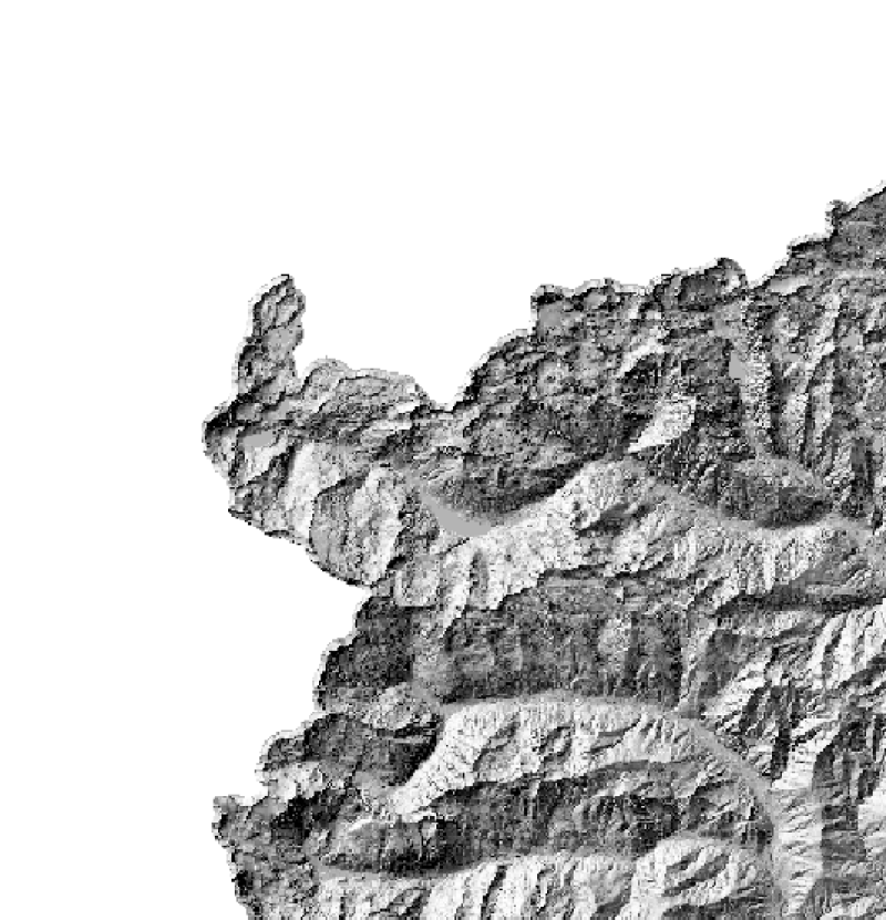
RIPRESA AEREA ICE 2009-2011 - Rilievo ombreggiato
Il Rilievo ombreggiato (hillshade) copre tutto il territorio regionale ed è stato calcolato a partire dal DTM Lidar contestuale alla RIPRESA AEREA ICE 2009-2011. La risoluzione della griglia (passo) è di 5 m.
Simple
- Date (Creation)
- 2011-07-28
- Citation identifier
- r_piemon:e10eb79d-b61b-44b3-804d-9adc082abbd3
- Cited responsible party
-
Organisation name Individual name Electronic mail address Role Regione Piemonte - A1613B - Sistema informativo territoriale e ambientale
cartografico@regione.pie cartografico@regione.piemonte.it
Custodian Regione Piemonte
info-geoportale@regione.piemonte.it geoportale@regione.pie info-geoportale@regione.piemonte.it
Owner
- Presentation form
- Digital image
- Issue identification
-
r_piemon:e10eb79d-b61b-44b3-804d-9adc082abbd3
- Point of contact
-
Organisation name Individual name Electronic mail address Role Regione Piemonte - A1613B - Sistema informativo territoriale e ambientale
cartografico@regione.pie cartografico@regione.piemonte.it
Point of contact
- Maintenance and update frequency
- Not planned
- Keywords
-
-
RNDT
-
- Keywords
-
-
EU
-
- Keywords
-
-
opendata
-
- Keywords
-
-
DTM
-
-
GEMET- Concepts version 2.4
-
-
forme del rilievo terrestre
-
-
Spatial scope
-
-
Regionale
-
- Access constraints
- Other restrictions
- Other constraints
- no limitations to public access
- Use constraints
- Other restrictions
- Other constraints
- Spatial representation type
- Grid
- Denominator
- 5000
- Language
- Italiano
- Character set
- UTF8
- Topic category
-
- Imagery base maps earth cover
))
- Begin date
- 2011-07-28
- End date
- 2012-03-15
- Unique resource identifier
- WGS84/UTM 32N
- Distribution format
-
Name Version GeoTIFF
1.0
- Distributor contact
-
Organisation name Individual name Electronic mail address Role Regione Piemonte - A1613B - Sistema informativo territoriale e ambientale
cartografico@regione.pie cartografico@regione.piemonte.it
Distributor
- OnLine resource
- Hierarchy level
- Dataset
Conformance result
- Date (Publication)
- 2010-12-08
- Explanation
-
Fare riferimento alle specifiche indicate
Quantitative result
- Value
- 4
- Statement
-
- volo aereofotogrammetico con rilievo LiDAR (Leica ALS )- quota di volo relativa 4500 m- ricoprimento long. tra il 55% e il 70%- processamento dei dati GPSINS- filtraggio e classificazione dei dati LiDAR - editing manuale dei dati LiDAR classificati- ottenimento della nube di punti XYZ- trasformazione al sistema di riferimento ETRS89UTM-zone32N- interpolazione su griglia regolare (5m)- calcolo del rilievo ombreggiato (hillshade, shaded relief) con strumenti di processing
Metadata
- File identifier
- r_piemon:e10eb79d-b61b-44b3-804d-9adc082abbd3 XML
- Metadata language
- Italiano
- Character set
- UTF8
- Hierarchy level
- Dataset
- Date stamp
- 2021-12-13
- Metadata standard name
-
Linee Guida RNDT
- Metadata standard version
-
2.0
- Metadata author
-
Organisation name Individual name Electronic mail address Role Regione Piemonte - A1613B - Sistema informativo territoriale e ambientale
cartografico@regione.pie cartografico@regione.piemonte.it
Point of contact
Overviews

Spatial extent
Provided by
