 INSPIRE Geoportal
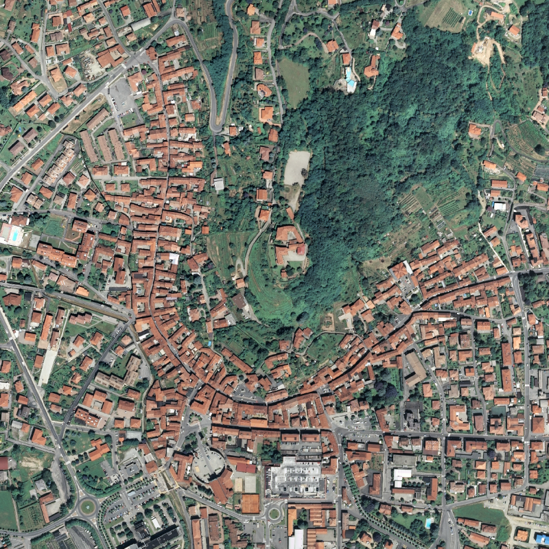
Ripresa aerea ICE 2009-2011 Ortofoto RGB - Geoservizi WMS e WMTS
I geoservizi WMS e WMTS Ortofoto volo ICE 2009 - 2011 permettono la visualizzazione delle ortofoto a colori del volo ICE georiferite nel sistema di riferimento UTM 32N WGS84 sull’intero territorio regionale.Nell'area di Biella (Occhieppo Superiore/Occhieppo Inferiore) è presente una strisciata nella quale non sono presenti dati.
Simple
Identification info
- Date (Publication)
- 2013-03-15
- Citation identifier
- r_piemon:ec27a3da-2bd8-4f7d-8905-3ac28f488943
- Cited responsible party
-
Organisation name Individual name Electronic mail address Role Regione Piemonte - A1613B - Sistema informativo territoriale e ambientale
cartografico@regione.pie cartografico@regione.piemonte.it
Custodian Regione Piemonte
info-geoportale@regione.piemonte.it geoportale@regione.pie info-geoportale@regione.piemonte.it
Owner
- Point of contact
-
Organisation name Individual name Electronic mail address Role Regione Piemonte - A1613B - Sistema informativo territoriale e ambientale
cartografico@regione.pie cartografico@regione.piemonte.it
Point of contact
-
ISO - 19119 geographic services taxonomy
- Keywords
-
-
RNDT
-
- Keywords
-
-
EU
-
- Access constraints
- Other restrictions
- Other constraints
- no limitations to public access
- Use constraints
- Other restrictions
- Other constraints
- Service Type
- view
))
- Coupling Type
- Tight
- Contains Operations
-
Operation Name Distributed Computing Platforms Connect Point GetMap
Web services http://geomap.reteunitaria.piemonte.it/ws/taims/rp-01/taimsortoregp/wms_ortoregp2010
- Operates On
- Distribution format
-
Name Version OGC:WMS
1.3.0
OGC:WMTS
1.0
- OnLine resource
-
Protocol Linkage Name Web Map Service (WMS) https://geomap.reteunitaria.piemonte.it/mapproxy/service?service=WMS&version=1.3.0&request=getCapabilities rp_ortofoto_2010
- OnLine resource
-
Protocol Linkage Name Web Map Tile Service (WMTS) https://geomap.reteunitaria.piemonte.it/WEBCAT/CAPABILITIES/wmts_rp_ortofoto_2010.xml WMTS
- Hierarchy level
- Service
- Other
-
servizio
Conformance result
- Date (Publication)
- 2009-10-19
- Explanation
-
non conforme
- Pass
- No
Metadata
- File identifier
- r_piemon:ec27a3da-2bd8-4f7d-8905-3ac28f488943 XML
- Metadata language
- Italiano
- Character set
- UTF8
- Hierarchy level
- Service
- Hierarchy level name
-
servizio
- Date stamp
- 2023-02-15
- Metadata standard name
-
Linee Guida RNDT
- Metadata standard version
-
2.0
- Metadata author
-
Organisation name Individual name Electronic mail address Role Regione Piemonte - A1613B - Sistema informativo territoriale e ambientale
cartografico@regione.pie cartografico@regione.piemonte.it
Point of contact
Overviews

Spatial extent
Provided by
